Abidjan–Lagos Corridor
Abidjan–Lagos
Mégalopole Abidjan–Lagos | |
|---|---|
 | |
| Nickname: West African Megalopolis | |
| Coordinates: 5°30′N 0°00′E / 5.5°N 0°E | |
| Countries | |
| Largest city | Lagos (14,368,332) |
| Population (2016) | |
• Total | 27,000,000 |
| [1] | |
| Time zone | GMT (UTC±00:00) — Côte d'Ivoire, Ghana, Togo WAT (UTC+01:00) — Benin and Nigeria |

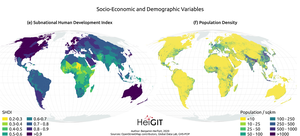
The Abidjan–Lagos Corridor, also known as the Abidjan–Lagos Megalopolis, is an emerging transnational megalopolis on the coast of southern West Africa. It stretches from Abidjan to Lagos, crossing five independent states (Côte d'Ivoire, Ghana, Togo, Benin, and Nigeria) from west to east, and includes two political capitals and many regional economic centers.[2] The corridor has a length of approximately 965 kilometers (600 miles). Within the megalopolis, a significant portion of West Africa's economic output is generated, and cities within the corridor are among the most economically developed of their respective countries, for which agglomeration effects and access to the Atlantic Ocean are responsible. The population within the region is experiencing rapid growth, and nearly 50 million people are expected to live within the corridor by 2035. According to projections, by the end of the 21st century, the region could become the largest urban region with continuous settlement in the world, then with up to half a billion inhabitants.[3]
After the decolonization of Africa, politically independent states emerged in West Africa and urban growth accelerated. Migrants moved from the interior to the more developed coastal areas, for example in Ghana to the region around Accra or in Nigeria to the metropolitan region of Lagos. Rapid urban growth led to the merging of previously independent settlements into large agglomerations with an economic division of labor. This occurred first domestically and later in transnational regions (e.g., between Lagos and neighboring Benin). However, urban growth was largely unplanned and led to severe urban sprawl, as little investment was made in the construction of multi-story housing. Future investment needs are therefore very high.[3]
Due to the linguistic, cultural and political differences between the countries located in the corridor, the region's economic potential has not yet been fully exploited. There has been little alignment of standards and construction of common infrastructure, and even within the countries, transportation links are often unreliable.[3]
Cities
[edit]
Listed from west to east.
| City | Country | Population
(2020)[4] |
Principal languages | Picture |
|---|---|---|---|---|
| Abidjan | 5,516,000 | French, Abidjan French, Attié, Baoulé, Bété, Wobé, Ebrié | 
| |
| Sekondi-Takoradi | 1,078,000 | Fante, English | 
| |
| Cape Coast | 189,925 (2010)[5] | Fante, English | 
| |
| Accra | 2,557,000 | English, Twi, Dagbani, Ga, Akan | 
| |
| Lomé | 2,200,000 | French, Ewe | 
| |
| Abomey-Calavi | 1,315,000 | French, Fon | 
| |
| Cotonou | 2,000,000 | French, Fon, Yoruba | 
| |
| Porto-Novo | 264,320 (2013)[6] | French, Fon, Yoruba | 
| |
| Lagos | 27,315,824 | English, Nigerian Pidgin, Yoruba | 
|
Abidjan-Lagos Highway
[edit]
Construction of a highway route from Abidjan to Lagos (Abidjan-Lagos Highway) is scheduled to begin in 2026, with completion targeted for 2030.[7] The project, spanning 1,028 km (639 mi), is expected to cost $15.6 billion and increase regional economic integration.[7] The African Development Bank is involved in the financing.[8][9] So far, the Dakar-Lagos Highway forms the main transport axis in the region.
Airports
[edit]- Cadjehoun Airport, Cotonou
- Félix-Houphouët-Boigny International Airport, Abidjan
- Kotoka International Airport, Accra
- Lomé–Tokoin International Airport, Lomé
- Murtala Muhammed International Airport, Lagos
- Takoradi Airport, Sekondi-Takoradi
Metro systems
[edit]Ports
[edit]External links
[edit]- The Lagos Abidjan Corridor doctoral thesis at ETH Zürich
References
[edit]- ^ "Abidjan-Lagos Corridor: UNAIDS, ECOWAS, FG Target 27m People on Health Security – THISDAYLIVE". www.thisdaylive.com.
- ^ Choplin, Armelle; Hertzog, Alice (2020-09-04). "The West African corridor from Abidjan to Lagos: a megacity-region under construction". Handbook of Megacities and Megacity-Regions: 206–222.
- ^ a b c "Megalopolis: how coastal west Africa will shape the coming century". the Guardian. 2022-10-27. Retrieved 2022-11-18.
- ^ "World Urbanization Prospects - Population Division - United Nations". Retrieved 2022-11-18.
- ^ "Ghana: Regions, Major Cities & Urban Localities - Population Statistics, Maps, Charts, Weather and Web Information". Retrieved 2022-11-18.
- ^ "Benin: Departments, Major Cities & Towns - Population Statistics, Maps, Charts, Weather and Web Information". Retrieved 2022-11-18.
- ^ a b Melly, Paul (2024-12-15). "West African bloc pins hopes on ambitious superhighway from Ivory Coast to Nigeria". BBC News. Retrieved 2024-12-15.
- ^ "US$15bn Lagos-Abidjan highway project receives lifeline". Africa Investment Forum. 2022-06-24. Retrieved 2022-11-18.
- ^ "$15.6bn Abidjan Lagos highway: Ghana route most profitable". Ministry of Roads and Highways. 2022-06-30. Retrieved 2022-11-18.

