Žiželice (Kolín District)
Žiželice | |
|---|---|
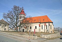
 Church of Saint Procopius with a protected small-leaved linden | |
| Coordinates: 50°7′55″N 15°23′36″E / 50.13194°N 15.39333°E | |
| Country | |
| Region | Central Bohemian |
| District | Kolín |
| First mentioned | 1052 |
| Area | |
• Total | 18.61 km2 (7.19 sq mi) |
| Elevation | 211 m (692 ft) |
| Population (2024-01-01)[1] | |
• Total | 1,807 |
| • Density | 97/km2 (250/sq mi) |
| Time zone | UTC+1 (CET) |
| • Summer (DST) | UTC+2 (CEST) |
| Postal codes | 281 26, 281 29 |
| Website | www |
Žiželice is a municipality and village in Kolín District in the Central Bohemian Region of the Czech Republic. It has about 1,800 inhabitants.
Administrative parts
[edit]The villages of Hradišťko II, Končice, Kundratice, Loukonosy, Pod Vinicí and Zbraň are administrative parts of Žiželice.
Etymology
[edit]The initial name of the village was Žuželice. The name was derived from the personal name Žužel, meaning "the village of Žužel's people".[2]
Geography
[edit]Žiželice is located about 17 kilometres (11 mi) northeast of Kolín and 28 km (17 mi) northwest of Pardubice. It lies in a flat and mostly agricultural landscape in the Central Elbe Table. The highest point is at 248 m (814 ft) above sea level. The Cidlina River flows through the municipality.
History
[edit]The first written mention of Žiželice is from 1052, when there was already a church and the village served as a market centre. In 1321, the then owner of Žiželice, Lord Dětoch, founded a new village called Žiželice next to the old village and renamed the old village Končice. From the 14th century, the estate was owned by the Rosenberg family. Peter I of Rosenberg had demolished the old wooden church in 1347 and had built a new one. During the Hussite Wars in 1425, the village was burned down, but soon was restored. At the end of the Thirty Years' War, Žiželice was again burned down.[3]
In the 19th century, the railway was built and Žiželice was industrialized. There used to be a sugar factory and a textile factory.[3]
Demographics
[edit]
|
|
| ||||||||||||||||||||||||||||||||||||||||||||||||||||||
| Source: Censuses[4][5] | ||||||||||||||||||||||||||||||||||||||||||||||||||||||||
Transport
[edit]The D11 motorway (part of the European route E67) from Prague to Hradec Králové passes through the municipality.
Sights
[edit]The main landmark of Žiželice is the Church of Saint Procopius. It was built in the Gothic style after 1347 and modified in 1712. After being damaged by a fire in 1830, the church was reconstructed and its early Baroque equipment was replaced with a new one.[6]
References
[edit]- ^ "Population of Municipalities – 1 January 2024". Czech Statistical Office. 2024-05-17.
- ^ Profous, Antonín (1957). Místní jména v Čechách IV: S–Ž (in Czech). pp. 854–855.
- ^ a b "Historie" (in Czech). Obec Žiželice. Retrieved 2023-03-23.
- ^ "Historický lexikon obcí České republiky 1869–2011" (in Czech). Czech Statistical Office. 2015-12-21.
- ^ "Population Census 2021: Population by sex". Public Database. Czech Statistical Office. 2021-03-27.
- ^ "Kostel sv. Prokopa". Cesty a památky (in Czech). Retrieved 2023-03-23.
External links
[edit]

