
Čabiny
Čabiny | |
|---|---|
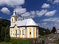
 Panorama of the village with Orthodox church | |
 Flag | |
 Čabiny Location of Čabiny in the Prešov Region  Čabiny Location of Čabiny in Slovakia | |
| Coordinates: 49°11′N 21°54′E / 49.18°N 21.90°E | |
| Country | |
| Region | |
| District | Medzilaborce District |
| First mentioned | 1478 |
| Area | |
• Total | 38.84 km2 (15.00 sq mi) |
| Elevation | 253 m (830 ft) |
| Population (2021)[3] | |
• Total | 296 |
| Time zone | UTC+1 (CET) |
| • Summer (DST) | UTC+2 (CEST) |
| Postal code | 670 2[2] |
| Area code | +421 57[2] |
| Car plate | ML |
| Website | www |
Čabiny (Rusyn: Чабины, Ukrainian: Чабини; Hungarian: Csebény) is a village and municipality in the Medzilaborce District in the Prešov Region of far north-eastern Slovakia.
History
[edit]In historical records the village was first mentioned in 1478. Before the establishment of independent Czechoslovakia in 1918, it was part of Zemplén County within the Kingdom of Hungary.
Geography
[edit]The municipality lies at an altitude of 250 metres and covers an area of 38.847 km². It has a population of about 430 people.
Genealogical resources
[edit]The records for genealogical research are available at the state archive "Statny Archiv in Presov, Slovakia"
- Roman Catholic church records (births/marriages/deaths): 1786-1898 (parish B)
- Greek Catholic church records (births/marriages/deaths): 1799-1895 (parish A)
Gallery
[edit]-
 Orthodox church of the Nativity of Our Lady in Čabiny
 -
 Greek Catholic Church of the Nativity of Our Lady in Čabiny


See also
[edit]References
[edit]- ^ "Hustota obyvateľstva - obce [om7014rr_ukaz: Rozloha (Štvorcový meter)]". www.statistics.sk (in Slovak). Statistical Office of the Slovak Republic. 2022-03-31. Retrieved 2022-03-31.
- ^ a b c "Základná charakteristika". www.statistics.sk (in Slovak). Statistical Office of the Slovak Republic. 2015-04-17. Retrieved 2022-03-31.
- ^ "Počet obyvateľov podľa pohlavia - obce (ročne)". www.statistics.sk (in Slovak). Statistical Office of the Slovak Republic. 2022-03-31. Retrieved 2022-03-31.
External links
[edit]Municipalities of Medzilaborce District | ||
|---|---|---|
This Prešov Region geography article is a stub. You can help Wikipedia by expanding it. |