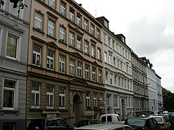
Altona-Altstadt
Appearance
You can help expand this article with text translated from the corresponding article in German. (July 2016) Click [show] for important translation instructions.
|
Altona-Altstadt | |
|---|---|
 Virchowstraße | |
| Coordinates: 53°32′56″N 9°56′52″E / 53.54889°N 9.94778°E | |
| Country | Germany |
| State | Hamburg |
| City | Hamburg |
| Borough | Altona |
| Area | |
• Total | 2.8 km2 (1.1 sq mi) |
| Population (2023-12-31)[1] | |
• Total | 29,715 |
| • Density | 11,000/km2 (27,000/sq mi) |
| Time zone | UTC+01:00 (CET) |
| • Summer (DST) | UTC+02:00 (CEST) |
| Dialling codes | 040 |
| Vehicle registration | HH |
ⓘ is a quarter in Hamburg (Germany) that belongs to the Altona borough. The quarter's boundaries are congruent with the historic center of what has been the city of Altona until 1937.
History
[edit]Altona was founded in 1535 and became a city in 1664. In 1713, it was burned down by Swedish troops. In 1937, it became part of the city of Hamburg.
Geography
[edit]Altona-Altstadt is located between the quarters of Ottensen, Altona-Nord, Sternschanze and St. Pauli. In the south, it borders with the Elbe river.
Politics
[edit]These are the results of Altona-Altstadt in the Hamburg state election:
| Election | Greens | SPD | Left | CDU | AfD | FDP | Others |
|---|---|---|---|---|---|---|---|
| 2020 | 34,0 % | 25,0 % | 24,2 % | 3,6 % | 2,7 % | 2,1 % | 8,4 % |
| 2015 | 22,3 % | 35,2 % | 23,8 % | 5,0 % | 3,0 % | 3,2 % | 7,5 % |
| 2011 | 17,7 % | 46,6 % | 16,5 % | 7,1 % | – | 2,4 % | 9,7 % |
| 2008 | 17,5 % | 41,1 % | 13,7 % | 21,4 % | – | 2,9 % | 3,4 % |
| 2004 | 26,3 % | 34,4 % | – | 26,5 % | – | 1,7 % | 11,1 % |
References
[edit]


