Zaveh County
Appearance
(Redirected from Zave County)
Zaveh County
Persian: شهرستان زاوه | |
|---|---|
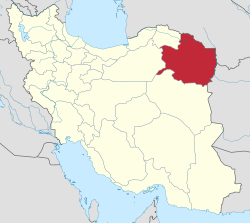
 Location of Zaveh County in Razavi Khorasan province (center right, green) | |
 Location of Razavi Khorasan province in Iran | |
| Coordinates: 35°15′N 59°43′E / 35.250°N 59.717°E[1] | |
| Country | Iran |
| Province | Razavi Khorasan |
| Capital | Dowlatabad |
| Districts | Central, Soleyman |
| Area | |
• Total | 2,575 km2 (994 sq mi) |
| Elevation | 1,750 m (5,740 ft) |
| Population (2016)[2] | |
• Total | 67,695 |
| Time zone | UTC+3:30 (IRST) |
Zaveh County (Persian: شهرستان زاوه)[a] is in Razavi Khorasan province, Iran. Its capital is the city of Dowlatabad.[3]
History
[edit]After the 2006 National Census, Jolgeh Zaveh District was separated from Torbat-e Heydarieh County in the establishment of Zaveh County, which was divided into two districts of two rural districts each, with Dowlatabad as its capital and only city.[3]
Demographics
[edit]Population
[edit]At the time of the 2011 census, the county's population was 71,677 people in 19,743 households.[4] The 2016 census measured the population of the county as 67,695 in 20,063 households.[2]
Administrative divisions
[edit]Zaveh County's population history and administrative structure over two consecutive censuses are shown in the following table.
| Administrative Divisions | 2011[4] | 2016[2] |
|---|---|---|
| Central District | 40,701 | 38,384 |
| Safaiyeh RD | 14,057 | 13,087 |
| Zaveh RD | 17,038 | 15,968 |
| Dowlatabad (city) | 9,606 | 9,329 |
| Soleyman District | 30,855 | 29,307 |
| Saq RD | 16,147 | 16,472 |
| Soleyman RD | 14,708 | 12,835 |
| Total | 71,677 | 67,695 |
| RD = Rural District | ||
See also
[edit]![]() Media related to Zaveh County at Wikimedia Commons
Media related to Zaveh County at Wikimedia Commons
Notes
[edit]References
[edit]- ^ OpenStreetMap contributors (7 November 2024). "Zaveh County" (Map). OpenStreetMap (in Persian). Retrieved 7 November 2024.
- ^ a b c Census of the Islamic Republic of Iran, 1395 (2016): Razavi Khorasan Province. amar.org.ir (Report) (in Persian). The Statistical Center of Iran. Archived from the original (Excel) on 2 April 2022. Retrieved 19 December 2022.
- ^ a b Davodi, Parviz (28 October 2019) [Approved 28 July 2018]. Approval letter regarding the creation of Zaveh County with the center of Dowlatabad city under the citizenship of Razavi Khorasan province. rc.majlis.ir (Report) (in Persian). Ministry of the Interior, Council of Ministers. Proposal 78561/42/1/4; Notification 141605/T31734H. Archived from the original on 18 October 2020. Retrieved 26 November 2023 – via Islamic Parliament Research Center of the Islamic Republic of Iran.
- ^ a b Census of the Islamic Republic of Iran, 1390 (2011): Razavi Khorasan Province. irandataportal.syr.edu (Report) (in Persian). The Statistical Center of Iran. Archived from the original (Excel) on 20 January 2023. Retrieved 19 December 2022 – via Iran Data Portal, Syracuse University.

