
Xam Neua
Xam Neua
ເມືອງຊຳເໜືອ Sam Neua or Samneua | |
|---|---|
| Xam Neua District | |
 | |
 Xam Neua Location in Laos | |
| Coordinates: 20°24′54″N 104°02′53″E / 20.415°N 104.048°E | |
| Country | |
| Admin. division | Houaphanh Province |
| Population (2015)[1] | |
• Total | 56,900 |
| • Religions | Buddhism |
| Time zone | UTC+7 (ICT) |
Xam Neua (Lao: ຊຳເໜືອ, romanized: Sam Nư̄a, pronounced [sám nɯ̌a], sometimes transcribed as Sam Nuea or Samneua, literally 'northern swamp'; French: Xam-Nua), is the capital of Houaphanh Province, Laos.
History
[edit]After fleeing from Phrae, deposed king Phiriya Thepphawong escaped from Northern Thailand to Luang Prabang, residing in Xam Neua from 1903-1909.[2]
Climate
[edit]| Climate data for Xam Neua, elevation 1,000 m (3,300 ft), (1990–2019) | |||||||||||||
|---|---|---|---|---|---|---|---|---|---|---|---|---|---|
| Month | Jan | Feb | Mar | Apr | May | Jun | Jul | Aug | Sep | Oct | Nov | Dec | Year |
| Mean daily maximum °C (°F) | 20.3 (68.5) |
22.9 (73.2) |
26.2 (79.2) |
28.6 (83.5) |
29.1 (84.4) |
29.1 (84.4) |
28.7 (83.7) |
28.3 (82.9) |
27.2 (81.0) |
24.9 (76.8) |
23.0 (73.4) |
20.0 (68.0) |
25.7 (78.2) |
| Mean daily minimum °C (°F) | 9.7 (49.5) |
10.7 (51.3) |
13.5 (56.3) |
16.8 (62.2) |
19.2 (66.6) |
20.7 (69.3) |
20.7 (69.3) |
20.4 (68.7) |
19.2 (66.6) |
17.2 (63.0) |
13.8 (56.8) |
10.4 (50.7) |
16.0 (60.9) |
| Average precipitation mm (inches) | 20 (0.8) |
8 (0.3) |
47 (1.9) |
111 (4.4) |
190 (7.5) |
198 (7.8) |
283 (11.1) |
284 (11.2) |
210 (8.3) |
95 (3.7) |
28 (1.1) |
13 (0.5) |
1,487 (58.6) |
| Average precipitation days (≥ 1.0 mm) | 2.1 | 1.1 | 4.7 | 8.6 | 11.2 | 10.6 | 14.9 | 15.6 | 10.5 | 7.2 | 2.7 | 1.8 | 91 |
| Source 1: Food and Agriculture Organization of the United Nations[3] | |||||||||||||
| Source 2: Meteomanz (precipitation days 2002–2020)[4] | |||||||||||||
Daily life
[edit]It is said that there is a communist re-education camp in Xam Neua and that it was the Pathet Lao capital during the Laotian Civil War Battle of Lima Site 85 (LS-85), 11 March 1968. It is near the Pathet Lao refuges in the Viengxay caves, which the Lao government hopes to promote as a tourism destination similar to the Củ Chi tunnels near Ho Chi Minh City in Vietnam and the Killing Fields Memorial near Phnom Penh in Cambodia. It is near Nam Et-Phou Louey National Protected Area (pronounced "naam et poo loo-ee").[5]
-
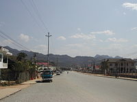 Sam Neua's main street
 -
 Wat Pho Xai
 -
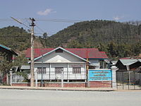 Lao Front for National Construction building, Xam Neua


References
[edit]- ^ "Results of Population and Housing Census 2015" (PDF). Lao Statistics Bureau. Retrieved 19 February 2024.
- ^ "จากแพร่ถึงเชียงราย ไม่ยอมพ่ายแก่โควิด". Thai Post | อิสรภาพแห่งความคิด. Retrieved 2023-06-27.
- ^ "Climatology and agroclimatology atlas of the Lao People's Democratic Republic" (PDF). Food and Agriculture Organization of the United Nations. Archived from the original (PDF) on 17 March 2024. Retrieved 17 March 2024.
- ^ "SYNOP/BUFR observations. Data by months". Meteomanz. Retrieved 22 February 2025.
- ^ "Nam Et". Archived from the original on 2011-06-14. Retrieved 2010-09-25.
External links
[edit] Sam Neua travel guide from Wikivoyage
| International | |
|---|---|
| National | |
| Other | |