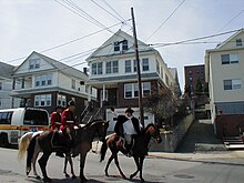
Winter Hill, Somerville, Massachusetts
Winter Hill is a neighborhood in Somerville, Massachusetts, United States. It takes its name from the 120-foot hill that occupies its landscape, the name of which dates back to the 18th century.[1] Winter Hill is located roughly north of Medford Street, west of McGrath Highway, and east of Magoun Square.
History[edit]

An early map of the area (dated 1637) from the papers of the family of John Winthrop includes some of this neighborhood and the adjacent Ten Hills section.[2] A Map of the Battle of Bunker Hill from 1775 displays Winter Hill to the northwest, with woody and marshy regions beyond.[3] A map by Henry Pelham published in 1777 includes the Winter Hill Fort as part of the "Military Works" in the area.[4] The Winter Hill Fort was described as "extensive" among other American Revolutionary War installations, but little evidence of the structural features remains.[5] A "Plan of the Rebels Works" in the Library of Congress collection offers a glimpse of the layout.[6] This stronghold is also diagrammed in a map credited to John Montrésor indicating that this was a part of Charlestown at the time.[7] The "Midnight Ride" of Paul Revere crossed over Winter Hill, and is re-enacted each year as part of the Patriots' Day festivities in the Boston area.

Numerous buildings included in the National Register of Historic Places are found in this neighborhood, including the Adams-Magoun House, the Charles Adams-Woodbury Locke House, the Broadway Winter Hill Congregational Church and the Elisha Hopkins House among others. Historical features of the neighborhood include the antique but still useable fire alarm call boxes by the Gamewell company.[8]

An apartment in the Langmaid Terrace building on Winter Hill at 365 Broadway Avenue was the home of Barack Obama between 1988 and 1991 while he was a student at Harvard Law School.[9]
By the 21st century, Winter Hill featured a mix of restored homes and aging triple deckers, replete with china gnomes and bathtub Virgin Marys. Once known as the home base of Irish gangsters Whitey Bulger, James "Buddy" McLean, Howie Winter and the notorious Winter Hill Gang, Winter Hill is now, as much of the rest of Somerville, experiencing gentrification and a resulting rise in property values and rents.[10] Despite these changes, the area continues to hang onto its neighborhood flavor and is home to a large community of Irish and Italian people.
Winter Hill is home to a variety of eateries, Mama Lisa's and Leone's pizza establishments, Sarma, Tipping Cow, the Winter Hill Bakery, and the Winter Hill Brewing Company. A number of new restaurants, cafes, and shops are in the late planning stages. Neighborhood Produce, a small community-based grocery store, serves the neighborhood from a location on Medford St., next to the Winter Hill Community School. The Theater Coop, one of the Boston area's few new repertory live theaters, is located between Foss Park and the local supermarket. Near Winter Hill in East Somerville is a community pottery studio, called Mudflat, and a collective of stained glass artists called Daniel Maher Stained Glass.
Foss Park abuts Interstate 93 at the base of Winter Hill. The park has a large, colorful mural painted behind the public swimming pool, and is home to a wide variety of sporting matches, especially soccer.[11] At one time a portion of the Middlesex Canal was located on land that became this park.
An extension of the Green Line nicknamed the GLX, to the Winter Hill area has been completed, specifically with stations at Medford Street (Gilman Square) and Lowell Street (Magoun Square). Service began operating in December 2022[12]. As of December 2023, the line was still undergoing extensive work due to the tracks being initially installed using the wrong gauge.[13] Workers performed track work in the evenings while trolleys ran revenue service on the line during the day.[14]
Notes[edit]
- ^ Henry Pelham, A Plan of Boston in New England with its Environs, Including Milton, Dorchester, Roxbury, Brookline, Cambridge, Medford, Charlestown, Parts of Malden and Chelsea. With the Military Works Constructed in those Places in the Years 1775, and 1776 (London, Published according to Act of Parliament, 1777)
- ^ Ten Hills (Medford, Mass.), October 1637
- ^ Battle of Bunker Hill, 28 November 1775
- ^ A Plan of Boston in New England with its Environs, including Milton, Dorchester, Roxbury, Brooklin, Cambridge, Medford, Charlestown, Parts of Malden and Chelsea, with the Military Works Constructed in those Places in the Years 1775 and 1776 [1]
- ^ Winter Hill Fort
- ^ Plan of the rebels works on Winter-Hill
- ^ A draught of the towns of Boston and Charles Town and the circumjacent country shewing the works thrown up by His Majesty's troops, and also those by the rebels, during the campaign: 1775. [2]
- ^ "How a vintage technology — fire boxes — still works in Boston". www.wbur.org. 30 December 2018. Retrieved 11 July 2024.
- ^ Boston Globe, January 28, 2007 At Harvard Law, a unifying voice
- ^ "Skyrocketing rent has tenants searching outside the city - The Boston Globe". BostonGlobe.com. Retrieved 24 February 2017.
- ^ Somerville News, 19 January 2012 City plans face-lift for Foss Park
- ^ Patkin, Abby. "The GLX Medford branch is opening Monday. Here's what to know". www.boston.com. Retrieved 11 July 2024.
- ^ "Major track work remains on recently opened MBTA Green Line Extension, GM says". nbcboston.com. Retrieved 28 November 2023.
- ^ "Green Line". mbta.com. Retrieved 28 November 2023.
Bibliography[edit]
- Haskell, Albert L., Haskell's Historical Guide Book of Somerville, Massachusetts
- Frothingham, Richard. History of the Siege of Boston, and of the Battles of Lexington, Concord, and Bunker Hill. Little, Brown, & Company. 1903.

