Wabowden
Wabowden | |
|---|---|
 Sign for Wabowden, Manitoba, Canada | |
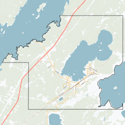
 Boundaries | |
| Coordinates: 54°54′32″N 98°37′47″W / 54.90889°N 98.62972°W | |
| Country | Canada |
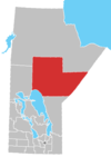
| Province | Manitoba |
| Region | Nor - Man |
| Government | |
| • MP | Niki Ashton |
| • MLA | Eric Redhead |
| Area | |
• Total | 34.42 km2 (13.29 sq mi) |
| Population | |
• Total | 442 |
| • Density | 12.8/km2 (33/sq mi) |
| Time zone | UTC−6 (CST) |
| • Summer (DST) | UTC−5 (CDT) |
| Postal code | R0B 1S0 |
| Area code | 204 |
| NTS Map | 063J15 |
| GNBC Code | GBCTE |
| Website | Community of Wabowden |
Wabowden is a community in northern Manitoba. It is situated on Provincial Trunk Highway No. 6, which is the main route between Thompson and the provincial capital, Winnipeg.
History
[edit]The community originated in the early 20th century as a service point on the Hudson Bay Railway. Although the railway's presence in Wabowden has diminished over time, it continues to serve the community by transporting freight and passengers.
| Preceding station | Following station | |||
|---|---|---|---|---|
| Lyddal toward Churchill
|
Winnipeg–Churchill | Pipun toward Winnipeg
| ||
| Former services | ||||
| Preceding station | Canadian National Railway | Following station | ||
| Medard toward Churchill
|
Hudson Bay Railway | Pipun toward The Pas
| ||
Wabowden's name is derived from that of a one-time railway executive, W.A. Bowden.
Demographics
[edit]In the 2021 Census of Population conducted by Statistics Canada, Wabowden had a population of 400 living in 138 of its 175 total private dwellings, a change of -9.5% from its 2016 population of 442. With a land area of 30.36 km2 (11.72 sq mi), it had a population density of 13.2/km2 (34.1/sq mi) in 2021.[2]
Climate
[edit]In spite of its latitude below the 55th parallel, Wabowden has a clear-cut rather than borderline subarctic climate.[3] Its climate is dominated by its long and bitterly cold winters, but the short summers are relatively warm, keeping Wabowden well below the tree line.
| Climate data for Wabowden | |||||||||||||
|---|---|---|---|---|---|---|---|---|---|---|---|---|---|
| Month | Jan | Feb | Mar | Apr | May | Jun | Jul | Aug | Sep | Oct | Nov | Dec | Year |
| Record high °C (°F) | 3 (37) |
7 (45) |
14 (57) |
30 (86) |
32 (90) |
34 (93) |
34 (93) |
32 (90) |
30 (86) |
25 (77) |
12 (54) |
4 (39) |
34 (93) |
| Mean daily maximum °C (°F) | −18 (0) |
−15 (5) |
−5 (23) |
4 (39) |
12 (54) |
17 (63) |
22 (72) |
20 (68) |
13 (55) |
6 (43) |
−6 (21) |
−15 (5) |
3 (37) |
| Daily mean °C (°F) | −22 (−8) |
−20 (−4) |
−11 (12) |
−2 (28) |
6 (43) |
11 (52) |
16 (61) |
14 (57) |
8 (46) |
2 (36) |
−9 (16) |
−18 (0) |
−2 (28) |
| Mean daily minimum °C (°F) | −27 (−17) |
−26 (−15) |
−18 (0) |
−8 (18) |
0 (32) |
5 (41) |
10 (50) |
8 (46) |
4 (39) |
−1 (30) |
−13 (9) |
−22 (−8) |
−7 (19) |
| Record low °C (°F) | −46 (−51) |
−44 (−47) |
−37 (−35) |
−30 (−22) |
−14 (7) |
−5 (23) |
1 (34) |
−1 (30) |
−8 (18) |
−16 (3) |
−36 (−33) |
−43 (−45) |
−46 (−51) |
| Average rainfall mm (inches) | 10 (0.4) |
10 (0.4) |
10 (0.4) |
20 (0.8) |
30 (1.2) |
70 (2.8) |
80 (3.1) |
60 (2.4) |
60 (2.4) |
20 (0.8) |
20 (0.8) |
10 (0.4) |
450 (17.7) |
| Source: [4] | |||||||||||||
Mining
[edit]Crowflight Minerals is currently preparing Bucko Lake Mine for rehabilitation. The mine shaft was developed in the 1970s by Falconbridge Limited.
Local media
[edit]- CBWMT (channel 10) (CBC)
Notable people
[edit]- Ernest Monias, musician
References
[edit]- ^ "Census Profile, 2016 Census". Statistics Canada, 2016 Census. April 14, 2017. Retrieved May 30, 2017.
- ^ "Population and dwelling counts: Canada and designated places". Statistics Canada. February 9, 2022. Retrieved September 3, 2022.
- ^ "Wabowden, Manitoba Climate Summary". Weatherbase. Retrieved July 15, 2015.
- ^ "Wabowden, Manitoba Travel Weather Averages (Weatherbase)". Weatherbase. Retrieved July 15, 2015.


