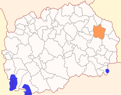
Vinica Municipality, North Macedonia
Vinica Municipality
Општина Виница | |
|---|---|
Urban municipality | |
 | |
| Country | |
| Region | |
| Municipal seat | Vinica |
| Government | |
| • Mayor | Mile Petkov (VMRO-DPMNE) |
| Area | |
| • Total | 432.67 km2 (167.05 sq mi) |
| Population | |
| • Total | 14,475 |
| • Density | 46.08/km2 (119.3/sq mi) |
| Time zone | UTC+1 (CET) |
| Area code | 033 |
| car plates | ST/VI[citation needed] |
| Website | http://www.vinica.gov.mk |
Vinica (Macedonian: Виница [ˈvinitsa] ) is a municipality in the eastern part of North Macedonia. Vinica is also the name of the town where the municipal seat is located. The Vinica Municipality is part of the Eastern Statistical Region.
Geography
[edit]The municipality borders the Kočani Municipality and Makedonska Kamenica Municipality to the north, Delčevo Municipality to the east, Radoviš Municipality and Berovo Municipality to the south, and Zrnovci Municipality to the west.
History
[edit]By the 2003 territorial division of Macedonia, the rural Blatec Municipality was annexed to Vinica Municipality.
Demographics
[edit]According to the 2002 Macedonian census, Vinica Municipality has 19,938 residents.[1] According to the 2021 North Macedonia census, this municipality has 14,475 inhabitants.[2] Ethnic groups in the municipality:
| 2002 | 2021 | |||
| Number | % | Number | % | |
| TOTAL | 19,938 | 100 | 14,475 | 100 |
| Macedonians | 18,261 | 91.59 | 11,929 | 82.41 |
| Roma | 1,230 | 6.17 | 744 | 5.14 |
| Turks | 272 | 1.36 | 173 | 1.2 |
| Vlachs | 121 | 0.61 | 89 | 0.61 |
| Serbs | 32 | 0.16 | 17 | 0.12 |
| Albanians | 8 | 0.06 | ||
| Other / Undeclared / Unknown | 22 | 0.11 | 78 | 0.53 |
| Persons for whom data are taken from administrative sources | 1,437 | 9.93 | ||
| Demographics of the Vinica municipality | ||||
|---|---|---|---|---|
| Census year | Population | Territorial Division 2003 | ||
| 1994 | 17,058 | |||
| 19,938 | ||||
| 2002 | 17,914 | |||
| 2021 | 14,475 | |||
| Demographics of the former Blatec Municipality | ||
|---|---|---|
| Census year | Population | |
| 1994 | 2,005 | |
| 2002 | 2,024 | |
Inhabited places
[edit]The number of inhabited places in the municipality is 16.
References
[edit]- ^ 2002 census results in English and Macedonian (PDF)
- ^ "Попис на населението, домаќинствата и становите во Република Северна Македонија, 2021 - прв сет на податоци" (PDF). stat.gov.mk. Retrieved 22 July 2022.


