Viimsi Parish
Viimsi Parish
Viimsi vald | |
|---|---|
 View of Viimsi Peninsula from the air above Lagedi | |
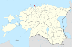
 Viimsi Parish within Harju County. | |
| Country | |
| County | |
| Administrative centre | Viimsi |
| Government | |
| • Mayor | Illar Lemetti (Estonian Reform Party) |
| Area | |
• Total | 72.84 km2 (28.12 sq mi) |
| Population (2019)[3] | |
• Total | 20 580 |
| ISO 3166 code | EE-890 |
| Website | www.viimsivald.ee |
Viimsi Parish (Estonian: Viimsi vald) is a rural municipality in Northern Estonia, located North-East and neighbouring the capital Tallinn. It occupies an area of 72.84 km2 (28.12 sq mi)[2] with a population of 20 580 (As of 2019[update]).[3] The municipality contains the Viimsi Peninsula and several islands, including Naissaar, Prangli, and Aksi.
The flag and coat of arms of Viimsi Parish were designed by the artist Tõnis Soop.[4][5] The mayor of Viimsi Parish is Illar Lemetti.
Divisions
[edit]There are two small boroughs (alevik) and 20 villages (küla) in Viimsi Parish.
Small boroughs
[edit]Villages
[edit]Äigrumäe, Idaotsa, Kelnase, Kelvingi, Laiaküla, Leppneeme, Lõunaküla (Storbyn), Lubja, Lääneotsa, Metsakasti, Miiduranna, Muuga, Pringi, Pärnamäe, Püünsi, Randvere, Rohuneeme, Tagaküla (Bakbyn), Tammneeme, Väikeheinamaa (Lillängin).
Religion
[edit]Religion in Viimsi Parish (2021) [1]
International relations
[edit]Twin towns — Sister cities
[edit]Viimsi Parish is twinned with:[6]
 Barleben, Germany
 Porvoo, Finland
 Ski Municipality, Norway
 Sulejówek, Poland
 Täby Municipality, Sweden
 Ramat Yishai, Israel
See also
[edit]References
[edit]- ^ "Vallavalitsuse koosseis" (in Estonian). Viimsi vald. 2010-05-26. Retrieved 28 May 2010.
- ^ a b "Population figure and composition". Statistics Estonia. 2010-04-19. Retrieved 28 May 2010.
- ^ a b "Viimsi vald alistas rahvaarvult Rakvere" (in Estonian). TV3. 2011-03-04. Retrieved 5 March 2011.
- ^ Soojärv, Anu. "Mural Kalad ('Fish') in the Administrative Building of the Kirov Collective Fishing Farm". Muinsuskaitsepäevad. Retrieved 13 March 2024.
- ^ "Sümboolika". Viimsi vald. Retrieved 13 March 2024.
- ^ "Välissuhted" (in Estonian). Viimsi vald. Retrieved 5 March 2011.
External links
[edit]- Official website (in Estonian)
59°32′N 24°51′E / 59.533°N 24.850°E


