Vaalhoek: Difference between revisions
Appearance
Content deleted Content added
m BOT: Checking dead links; Added 1 archived Wayback link |
No edit summary |
||
| Line 1: | Line 1: | ||
{{Location map|Botswana|lat=-26.88875046090|long=20.70028275793|caption=Location of Vaalhoek}} |
{{Location map|Botswana|lat=-26.88875046090|long=20.70028275793|caption=Location of Vaalhoek}} |
||
'''Vaalhoek''' is a village in [[Kgalagadi District]] of [[Botswana]]. It is located at the southern tip of Botswana, close to the border with [[South Africa]], and it has a primary school. The population was |
'''Vaalhoek''' is a village in [[Kgalagadi District]] of [[Botswana]]. It is located at the southern tip of Botswana, close to the border with [[South Africa]], and it has a primary school,clinic.Vaalhoek hs hd agreat deal of dvelopments for exmple;tared roads,electricity,communiction networks e.g.bemobile&mascom .The population was 837 in 2001 census.<ref>{{cite web |
||
| url=http://www.cso.gov.bw/html/census/dist90_91.html |
| url=http://www.cso.gov.bw/html/census/dist90_91.html |
||
| title=Distribution of population by sex by villages and their associated localities: 2001 population and housing census |
| title=Distribution of population by sex by villages and their associated localities: 2001 population and housing census |
||
Revision as of 11:41, 31 January 2012
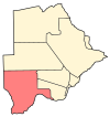
Location of Vaalhoek
Vaalhoek is a village in Kgalagadi District of Botswana. It is located at the southern tip of Botswana, close to the border with South Africa, and it has a primary school,clinic.Vaalhoek hs hd agreat deal of dvelopments for exmple;tared roads,electricity,communiction networks e.g.bemobile&mascom .The population was 837 in 2001 census.[1]
References
- ^ "Distribution of population by sex by villages and their associated localities: 2001 population and housing census". Archived from the original on 2007-11-24. Retrieved 2007-12-19.


