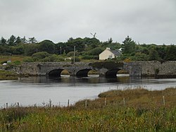
Toombeola
Toombeola
Tuaim Beola (Irish) | |
|---|---|
Townland | |
 Toombeola bridge | |
| Coordinates: 53°26′N 9°52′W / 53.433°N 9.867°W | |
| Country | Ireland |
| Province | Connacht |
| County | Galway |
| Irish grid reference | L756444 |
Toombeola (Irish: Tuaim Beola)[1] is a townland in the historical barony of Ballynahinch in Connemara, County Galway, Ireland.[2][3] It is located near the Atlantic Coast, 44 miles (71 km) west of Galway City, 4 miles (6.4 km) east of Roundstone, and 10 miles (16 km) south east of Clifden. As of the 2011 census, Toombeola townland had a population of 18 people.[4]
The area is also known locally as The Fishery, and the Owenmore River of the nearby fishery at Ballynahinch enters the sea at Toombeola Bridge.[citation needed] This bridge, built between 1828 and 1831,[5] was completed as part of road improvements in the Connemara undertaken by the Scottish engineer Alexander Nimmo.
History
[edit]The name Toombeola is an anglicisation of the Irish Tuaim Beola meaning 'tomb of Beola' or 'Beola's tumulus'.[6][7] Beola was an ancient chieftain in the Connemara area.[6]
A nearby Dominican abbey, St Patrick's, was founded in 1427.[8] The abbey is now in ruins, although the surrounding cemetery remains in use.[citation needed] The abbey was built with the help of a local chieftain of the O'Flaherty (Ó Flaithbertaigh) clan, who ruled over the Connemara region until the time of King James II of England.[6] The abbey was deserted by the Dominican Order between 1558 and 1559 following an attack by soldiers of the English crown.[6] According to local folklore, one of the last Dominican brothers to serve at the abbey, Fr. John Tully, swam across the Owenmore River in an effort to escape the attack, but was shot and killed by soldiers on the other side.[6] Locals buried him close to the site of his death, although no traces of a grave remain. Stones from the abbey were reputedly used by a local chieftain, Tadgh na Buile O'Flaherty, to build a castle on a small island on Ballynahinch Lake.[6] A dispute over the ownership of this castle led to a feud between Tadgh na Buile O'Flaherty and his cousin Teige Ó Flaithbheartaigh.[citation needed]
References
[edit]- ^ "Tuaim Beola / Toombeola". logainm.ie. Placenames Database of Ireland. Retrieved 25 May 2023.
- ^ "Information about Toombeola". places.galwaylibrary.ie. Galway Library. Archived from the original on 3 July 2022.
- ^ "Toombeola Townland, Co. Galway". townlands.ie. Retrieved 25 May 2023.
- ^ "CD155 - Galway Population by Private Households, Occupied and Vacancy Rate". data.gov.ie. Central Statistics Office. Retrieved 25 May 2023.
Townlands [..] Toombeola, Derrycunlagh, Co. Galway [..] 18
- ^ "Co. Galway, Toombeola (Ballinahinch), Bridge". Dictionary of Irish Architects. Royal Irish Academy. Retrieved 25 May 2023.
- ^ a b c d e f "Toombeola Abbey". visitgalway.ie. Retrieved 25 May 2023.
- ^ "Information about Timbola Abbey in Ruins". places.galwaylibrary.ie. Galway Library. Archived from the original on 7 August 2020.
- ^ Gwynn, Aubrey; Hadcock, R. Neville, eds. (1970). Medieval religious houses: Ireland. London: Longman. p. 230. ISBN 9780582112292.

