Timeline of the 2005 Pacific typhoon season
| Timeline of the 2005 Pacific typhoon season | |||||
|---|---|---|---|---|---|
 Season summary map | |||||
| Season boundaries | |||||
| First system formed | January 13, 2005 | ||||
| Last system dissipated | December 21, 2005 | ||||
| Strongest system | |||||
| Name | Haitang | ||||
| Maximum winds | 220 km/h (140 mph) (10-minute sustained) | ||||
| Lowest pressure | 920 hPa (mbar) | ||||
| Longest lasting system | |||||
| Name | ??? | ||||
| Duration | ?? days | ||||
| |||||
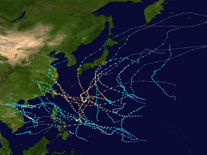
This timeline documents all of the events of the 2005 Pacific typhoon season, the period that tropical cyclones formed in the Western Pacific Ocean during the year. The scope of this article is limited to the Pacific Ocean, north of the equator between 100°E and the International Date Line. Tropical depressions that form in the basin were given a number with a "W" suffix by the United States' Joint Typhoon Warning Center (JTWC). If a depression intensified into a tropical storm, it would be assigned a name by the Japan Meteorological Agency (JMA). In addition, the Philippine Atmospheric, Geophysical and Astronomical Services Administration (PAGASA) assigned names to tropical cyclones which were in their area of responsibility.
During the season, a total of 33 systems were designated as tropical depressions by either the Japan Meteorological Agency (JMA), the Philippine Atmospheric, Geophysical and Astronomical Services Administration (PAGASA), the Joint Typhoon Warning Center (JTWC), or other national meteorological and hydrological services such as the China Meteorological Administration and the Hong Kong Observatory. Because the JMA runs the Regional Specialized Meteorological Centre for the Western Pacific, they assigned names to these systems once they intensified into a tropical storm. PAGASA also assigned their own local names to systems which were active within their area of responsibility; however, these names are not in common use outside of PAGASA's area of responsibility.
Timeline of storms
[edit]
January
[edit]
- January 13
-
- 1800 UTC – The Joint Typhoon Warning Center (JTWC) designates an area of low pressure as Tropical Depression 01W.[1]
- January 15
-
- 1200 UTC – The Japan Meteorological Agency (JMA) designates Tropical Storm 01W as Tropical Storm Kulap.[2]
- January 17
- January 18
- January 19
-
- 0600 UTC – The JMA issue their final advisory on Tropical Storm Kulap (01W) as the system becomes extratropical.[2]
February
[edit]No named storms formed in February.
March
[edit]
- March 13
-
- 1200 UTC – The JTWC designates an area of low pressure as Tropical Depression 02W.[3]
- March 14
-
- 0600 UTC – The JTWC upgrades Tropical Depression 02W to a tropical storm.[3]
- March 15
-
- 0000 UTC – The JMA designates Tropical Storm 02W as Tropical Storm Roke.[2]
- 1200 UTC – Tropical Storm Roke enters the Philippine area of responsibility and is designated Tropical Storm Auring by PAGASA for Philippine warnings.[4]
- 1800 UTC – The JTWC upgrades Tropical Storm 02W (Roke) to a typhoon.[3]
- 1500 UTC – Tropical Storm Roke (Auring) upgraded to Typhoon Roke (Auring).
- March 16
-
- 0000 UTC – PAGASA upgrades Tropical Storm Auring (Roke) to a severe tropical storm.[4]
- 0600 UTC – The JMA upgrades Tropical Storm Roke (02W) to a severe tropical storm.[2]
- 1200 UTC – Typhoon Roke (Auring) approaching landfall south of Borongan, Philippines.
- 1800 UTC – The JMA downgrades Severe Tropical Storm Roke (02W) to a tropical storm.[2]
- March 17
-
- 0000 UTC – The JTWC downgrades Typhoon 02W (Roke) to a tropical storm.[3]
- 0600 UTC – PAGASA downgrades Severe Tropical Storm Auring (Roke) to a tropical storm.[4]
- 1200 UTC – The JMA downgrades Tropical Storm Roke (02W) to a tropical depression.[2]
- 1800 UTC – The JTWC downgrades Tropical Storm 02W (Roke) to a tropical depression and the final advisory is issued.[3]
- 1800 UTC – PAGASA downgrades Tropical Storm Auring (Roke) to a tropical depression and the final advisory is issued.[4]
- March 19
- 0600 UTC – The JMA downgrades Tropical Depression Roke (02W) to an area of disturbed weather and the final advisory is issued.[2]
April
[edit]
- April 20
-
- 1200 UTC – Tropical Depression 03W forms 275 nautical miles (510 km) east-southeast of Yap Island.
- April 22
-
- 1200 UTC – Tropical Depression 03W enters the Philippine area of responsibility and is designated Tropical Depression Bising by PAGASA for Philippine warnings.
- April 23
- April 24
- April 26
May
[edit]- May 16
- May 17
- May 30
June
[edit]
- June 1
- June 2
- June 10
July
[edit]- July 4
-
- 0600 UTC – PAGASA designates Invest.93W as Tropical Depression Emong 35 nautical miles (65 km) northeast of Catarman Samar Island Philippines.
- July 11
-
- 1200 UTC – Tropical Depression 05W forms 110 nautical miles (200 km) southwest of Marcus Island, Japan.
- 1800 UTC – Tropical Depression 05W upgraded to Tropical Storm Haitang.
- July 13
-
- 1800 UTC – Tropical Storm Haitang upgraded to Typhoon Haitang.
- July 14
-
- 1200 UTC – Typhoon Haitang intensifies to a Category 2 storm.
- July 15
- July 16
-
- 0000 UTC – Typhoon Haitang (Feria) upgraded to category 5 Super Typhoon.
- July 17
- July 19
- July 20
-
- 0000 UTC – Tropical Depression 06W forms 330 nautical miles (610 km) north of Wake Island.
- 0600 UTC – Tropical Depression 06W upgraded to Tropical Storm Nalgae. Tropical Depression Haitang (Feria) dissipates Jiangxi, China.
- July 21
-
- 1200 UTC – Tropical Depression 07W forms 300 nautical miles (550 km) north of Yap Island in the Federated States of Micronesia.
- 1800 UTC – Tropical Depression 07W upgraded to Tropical Storm Banyan.
- July 23
-
- 1200 UTC – Tropical Storm Nalgae dissipates 615 nautical miles (1,140 km) north-northeast of Marcus Island, Japan.
- July 26
-
- Tropical Storm Banyan brushes the south and east coasts of Honshū Island, Japan.
- July 27
- July 28
-
- 1800 UTC – Tropical Depression 08W forms 215 nautical miles (400 km) south of Hong Kong.
- July 29
-
- 1200 UTC – Tropical Depression 08W upgraded to Tropical Storm Washi.
- July 30
-
- 0000 UTC – Tropical Storm Washi makes landfall on Hainan Island, China.
- July 31
-
- 0000 UTC – Tropical Depression 09W forms 130 nautical miles (240 km) west northwest of Yap Island.
- 0500 UTC – Tropical Storm Washi makes landfall near Nam Định, Vietnam.
- 0600 UTC – Tropical Depression 09W upgraded to Tropical Storm Matsa. Storm enters the Philippine area of responsibility and is assigned the name Tropical Storm Gorio for Philippine warnings.
- 1800 UTC – Tropical Depression Washi dissipates over northern Vietnam.
August
[edit]- August 2
-
- 0000 UTC – Tropical Storm Matsa (Gorio) upgraded to Typhoon Matsa (Gorio).
- August 4
-
- 1000 UTC – Typhoon Matsa (Gorio) passes over the Yaeyama Islands of Japan.
- 1200 UTC – Typhoon Matsa (Gorio) intensifies to a Category 2 storm.
- August 6
-
- 0000 UTC – Typhoon Matsa (Gorio) downgraded to a tropical storm.
- August 10
-
- 0000 UTC – Low-pressure system 93W designated Tropical Depression Huaning by PAGASA 320 nautical miles (590 km) east-northeast of Borongan Samar Island, Philippines.
- 1200 UTC – Joint Typhoon Warning Center reclassifies Low-pressure system 93W as Tropical Depression 10W (Huaning).
- August 11
- August 13
- August 19
-
- 1500 UTC – Tropical Depression 11W forms in the open Western Pacific.
- August 20
- August 21
- August 22
- August 25
- August 26
- August 27
- August 28
-
- 0600 UTC – Tropical Storm Talim upgraded to Typhoon Talim.
- August 29
-
- 0000 UTC – Typhoon Talim enters the Philippine area of responsibility and is assigned the name Typhoon Isang for Philippine warnings.
- 0000 UTC – Typhoon Talim (Isang) upgraded to a Category 2 storm.
- 0600 UTC – Tropical Depression 14W forms 365 nautical miles (675 km) east of Saipan.
- 0600 UTC – Typhoon Talim (Isang) upgraded to a Category 3 storm.
- 1200 UTC – Typhoon Talim (Isang) upgraded to a Category 4 storm.
- 1800 UTC – Tropical Depression 14W upgraded to Tropical Storm Nabi.
- August 30
-
- 1200 UTC – Tropical Storm Nabi upgraded to Typhoon Nabi.
- August 31
September
[edit]- September 1
-
- 0000 UTC – Typhoon Talim (Isang) downgraded to a Category 1 storm over Taiwan Strait.
- 0600 UTC – Typhoon Talim (Isang) downgraded to a Tropical Storm after landfall in China.
- 1200 UTC – Tropical Storm Talim (Isang) dissipates west of Fuzhou China.
- 1200 UTC – Typhoon Nabi upgraded to a Category 4 storm.
- 1800 UTC – Typhoon Nabi upgraded to a Category 5 storm and Super Typhoon Nabi.
- September 3
-
- 0000 UTC – Super Typhoon Nabi enters the Philippine area of responsibility and is assigned the name Super Typhoon Jolina for Philippine warnings.
- September 5
-
- 1800 UTC – Typhoon Nabi (Jolina) makes landfall in Kagoshima Prefecture, Japan.
- 1800 UTC – Tropical Depression 15W forms east of Yap.
- September 6
-
- 0000 UTC – Tropical Depression 15W upgraded to Tropical Storm 15W.
- 0600 UTC – Typhoon Nabi (Jolina) downgraded after landfall to Tropical Storm Nabi (Jolina).
- 1800 UTC – Tropical Storm Nabi (Jolina) becomes extratropical 30 nautical miles (55 km) west-northwest of Oki Island, Japan.
- 1800 UTC – Tropical Storm 15W enters the Philippine area of responsibility and is assigned the name Tropical Storm Kiko for Philippine warnings.
- September 7
-
- 0000 UTC – Tropical Storm 15W (Kiko) assigned the name Tropical Storm Khanun by Japan Meteorological Agency.
- September 8
-
- 1200 UTC – Tropical Storm Khanun (Kiko) strengthens into Typhoon Khanun (Kiko).
- September 9
-
- 1200 UTC – Typhoon Khanun (Kiko) upgraded to a category 2 storm.
- September 10
- September 11
- September 16
- September 18
- September 19
-
- 0900 UTC – PAGASA begins issuing advisories on Tropical Disturbance Labuyo.
- September 20
-
- 0000 UTC – Japan Meteorological Agency begins issuing marine warnings on a Tropical Depression.
- 1200 UTC – Tropical Disturbance Labuyo upgraded to Tropical Depression 17W (Labuyo).
- 1200 UTC – Tropical Depression 18W forms 220 nautical miles (410 km) southwest of Marcus Island, Japan.
- September 21
- September 22
- September 24
-
- 2100 UTC – Tropical Storm Damrey (Labuyo) upgraded to Typhoon Damrey (Labuyo).
- September 25
-
- 0900 UTC – Typhoon Damrey (Labuyo) upgraded to Category 2 storm.
- 2000 UTC – Typhoon Damrey (Labuyo) makes first landfall in Wanning, Hainan Province, China.
- 2100 UTC – Typhoon Saola downgraded to Tropical Storm Saola.
- September 26
-
- 0000 UTC – Tropical Storm Saola becomes extratropical off the coast of Japan.
- 0000 UTC – Joint Typhoon Warning Center initiates warning for Tropical Depression 19W which formed 335 nautical miles (620 km) south-southeast of Iwo Jima, Japan.
- 0900 UTC – Tropical Depression 19W upgraded to Tropical Storm Longwang.
- September 27
-
- 0300 UTC – Tropical Storm Longwang upgraded to Typhoon Longwang.
- 0900 UTC – Joint Typhoon Warning Center issues its last advisory on Tropical Storm Damrey (Labuyo), located 90 nautical miles (170 km) south-southwest of Hanoi dissipating inland.
- 0900 UTC – Typhoon Longwang upgraded to a category 2 storm.
- 1800 UTC – Typhoon Longwang upgraded to a category 3 storm.
- September 28
-
- 0600 UTC – Typhoon Longwang upgraded to a category 4 storm.
- September 29
- September 30
-
- 0900 UTC – Super Typhoon Longwang (Maring) downgraded to Typhoon Longwang (Maring).
October
[edit]- October 1
-
- 2100 UTC – Typhoon Longwang (Maring) makes landfall near Hualien City, Taiwan as a category 4 storm.
- October 2
-
- 1335 UTC – Typhoon Longwang (Maring) makes second landfall in Fujian Province, China.
- 2100 UTC – The Joint Typhoon Warning Center issues its last advisory on Tropical Storm Longwang (Maring), located over China about 200 nautical miles (370 km) west of Taipei, Taiwan, and dissipating inland.
- October 6
-
- 0000 UTC – Local bureaus initiate warnings for a low-pressure system near Hainan island.
- October 7
- October 9
-
- 1200 UTC – Japan Meteorological Agency initiates warnings for a tropical depression, previously classified Tropical Depression 21W by the JTWC.
- October 10
- October 11
- October 12
-
- 0900 UTC – Typhoon Kirogi (Nando) upgraded to a Category 4 typhoon by JTWC.
- October 15
-
- 2100 UTC – Typhoon Kirogi (Nando) re-upgraded to a Category 3 typhoon by JTWC.
- October 16
-
- 0900 UTC – Typhoon Kirogi (Nando) re-upgraded to a Category 4 typhoon by JTWC.
- October 19
-
- 0300 UTC – Typhoon Kirogi (Nando) becomes extratropical off the coast of Japan.
- October 28
-
- 2100 UTC – Joint Typhoon Warning Center initiates warnings for Tropical Depression 22W, 15 hours after the Japan Meteorological Agency issued a marine warning.
- October 29
-
- 0000 UTC – Tropical Depression 22W upgraded to Tropical Storm Kai-tak.
- October 30
November
[edit]- November 2
- November 7
- November 9
-
- 0900 UTC – Tropical Depression 23W (Ondoy) re-upgraded to Tropical Storm 23W (Ondoy).
- November 10
-
- 0300 UTC – Tropical Storm 23W (Ondoy) designated as Tropical Storm Tembin (Ondoy).
- circa 1600 UTC – Tropical Storm Tembin (Ondoy) makes landfall in northern Philippines.
- November 14
-
- 0000 UTC – Tropical Depression 24W named Tropical Depression Pepeng by PAGASA.
- November 15
-
- 0600 UTC – Tropical Depression 24W (Pepeng) upgraded to Tropical Storm 24W (Pepeng).
- November 16
-
- 0000 UTC – Tropical Storm 24W (Pepeng) redesignated Tropical Storm Bolaven (Pepeng).
- November 17
-
- 0000 UTC – Tropical Storm Bolaven (Pepeng) upgraded to Typhoon Bolaven (Pepeng).
- November 20
December
[edit]- December 19
-
- ca. 0300 UTC – Tropical Depression 25W (Quedan) strengthens into Tropical Storm 25W.
- December 20
- 0600 UTC – Tropical Storm 25W (Quedan) dissipates and advisories are discontinued.
See also
[edit]- 2005 Pacific typhoon season
- List of Pacific typhoon seasons
- Timeline of the 2005 Atlantic hurricane season
- Timeline of the 2005 Pacific hurricane season
References
[edit]- ^ a b c d e "Typhoon 01W (Kulap) JTWC Best Track". Joint Typhoon Warning Center. 2006. Retrieved 2009-05-07.
- ^ a b c d e f g h i "2005 JMA Best Tracks (all storms)". Japan Meteorological Agency. Archived from the original on December 10, 2006. Retrieved 2009-05-07.
- ^ a b c d e "Typhoon 02W (Roke) JTWC Best Track". Joint Typhoon Warning Center. Retrieved 2009-05-07.
- ^ a b c d "Tropical Storm Auring (Roke) PAGASA Best Track". PAGASA. Retrieved 2009-05-07.
- ^ a b "PAGASA Tropical Depression Crising Best Track". PAGASA. Retrieved 2009-05-07.
External links
[edit]- Japan Meteorological Agency
- National Weather Service Guam
- Hong Kong Observatory
- Korea Meteorological Administration
- Philippine Atmospheric, Geophysical and Astronomical Services Administration
- Taiwan Central Weather Bureau
- TCWC Jakarta
- Thai Meteorological Department
- Vietnam's National Hydro-Meteorological Service
- Joint Typhoon Warning Center Archived 2010-03-01 at the Wayback Machine
- Digital Typhoon – Typhoon Images and Information
- Typhoon2000 Philippine typhoon website
