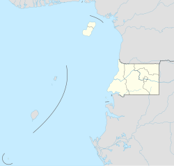
San Antonio de Ureca
Appearance
(Redirected from Ureka, Equatorial Guinea)
San Antonio de Ureca | |
|---|---|
Village | |
| Coordinates: 3°16′N 8°31′E / 3.267°N 8.517°E | |
| Country | |
| Province | Bioko Sur |
| Elevation | 186 m (610 ft) |
| Time zone | UTC+1 (WAT) |
| Climate | Am |
San Antonio de Ureca, also known as Ureka or Ureca is a village in Bioko Sur, Equatorial Guinea, south of Malabo on the island of Bioko. The town of Ureka is included among the wettest areas in the world; it receives about 10,450 millimeters (418 ins) of rainfall annually. It is the wettest place in Africa.[1]
Climate
[edit]This region on Bioko Island is the wettest place on the African continent. During the drier season from November to March, tourists flock to see turtles come ashore and lay eggs. Annual rainfall averages 10,450 millimetres or 410 inches.[2]
| Climate data for San Antonio de Ureca | |||||||||||||
|---|---|---|---|---|---|---|---|---|---|---|---|---|---|
| Month | Jan | Feb | Mar | Apr | May | Jun | Jul | Aug | Sep | Oct | Nov | Dec | Year |
| Average rainfall mm (inches) | 206 (8.1) |
129 (5.1) |
293 (11.5) |
243 (9.6) |
962 (37.9) |
2,032 (80.0) |
2,205 (86.8) |
1,867 (73.5) |
1,348 (53.1) |
560 (22.0) |
410 (16.1) |
191 (7.5) |
10,446 (411.2) |
| Source: [3] | |||||||||||||
References
[edit]- ^ Richard Frankham; Jonathan D. Ballou; David Anthony Briscoe (2004). A primer of conservation genetics. Cambridge University Press. ISBN 0-521-53827-0.
- ^ "San Antonio de Ureca Equatorial Guinea - Earth.com - Earth Image Gallery". www.earth.com. Retrieved 2024-10-11.
- ^ Bultot, F.; Griffiths, J.F. (1972). "The Equatorial Wet Zone". In Griffiths, J.F. (ed.). Climates of Africa. World Survey of Climatology. Vol. 10. Amsterdam: Elsevier Publishing. p. 286. ISBN 0-444-40893-2.


