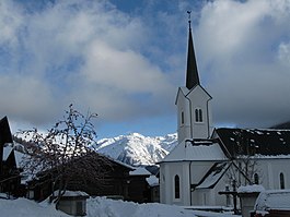
Ulrichen
Appearance
(Redirected from Ulrichen, Switzerland)
Ulrichen | |
|---|---|
 Ulrichen in December 2009 | |
| Coordinates: 46°30′N 8°18′E / 46.500°N 8.300°E | |
| Country | Switzerland |
| Canton | Valais |
| District | Goms |
| Municipality | Obergoms |
| Area | |
• Total | 444 km2 (171 sq mi) |
| Elevation | 1,346 m (4,416 ft) |
| Population (December 2007) | |
• Total | 219 |
| • Density | 0.49/km2 (1.3/sq mi) |
| Time zone | UTC+01:00 (Central European Time) |
| • Summer (DST) | UTC+02:00 (Central European Summer Time) |
| Postal code(s) | 3988 |
| SFOS number | 6071 |
| ISO 3166 code | CH-VS |
| Website | www |
Ulrichen is a village in the municipality of Obergoms in the district of Goms in the canton of Valais in Switzerland. The population (as of 2007[update]) was 219.[1]
Ulrichen was an independent municipality until January 1, 2009, when it merged with Oberwald and Obergesteln to form the municipality Obergoms.
In Ulrichen, an airport is located.
Climate
[edit]Ulrichen has a Subarctic climate (Dfc) according to the Köppen Climate Classification, bordering a Warm-Summer humid continental climate (Dfb). Precipitation is spread evenly throughout the year. The town is known to receive high amounts of snow during the winter months.
| Climate data for Ulrichen, elevation 1,346 m (4,416 ft), (1991–2020) | |||||||||||||
|---|---|---|---|---|---|---|---|---|---|---|---|---|---|
| Month | Jan | Feb | Mar | Apr | May | Jun | Jul | Aug | Sep | Oct | Nov | Dec | Year |
| Mean daily maximum °C (°F) | −0.8 (30.6) |
1.7 (35.1) |
5.9 (42.6) |
9.9 (49.8) |
14.9 (58.8) |
19.4 (66.9) |
21.8 (71.2) |
21.3 (70.3) |
17.3 (63.1) |
12.6 (54.7) |
5.1 (41.2) |
−0.3 (31.5) |
10.7 (51.3) |
| Daily mean °C (°F) | −7.2 (19.0) |
−5.4 (22.3) |
−0.4 (31.3) |
3.9 (39.0) |
8.7 (47.7) |
12.6 (54.7) |
14.6 (58.3) |
14.0 (57.2) |
10.0 (50.0) |
5.5 (41.9) |
−0.7 (30.7) |
−5.6 (21.9) |
4.2 (39.6) |
| Mean daily minimum °C (°F) | −13.0 (8.6) |
−12.1 (10.2) |
−6.5 (20.3) |
−1.8 (28.8) |
2.4 (36.3) |
5.5 (41.9) |
7.5 (45.5) |
7.3 (45.1) |
3.8 (38.8) |
0.2 (32.4) |
−5.2 (22.6) |
−10.6 (12.9) |
−1.9 (28.6) |
| Average precipitation mm (inches) | 97.0 (3.82) |
81.4 (3.20) |
89.3 (3.52) |
87.6 (3.45) |
116.0 (4.57) |
95.3 (3.75) |
86.3 (3.40) |
100.4 (3.95) |
88.9 (3.50) |
106.7 (4.20) |
124.2 (4.89) |
109.7 (4.32) |
1,182.8 (46.57) |
| Average snowfall cm (inches) | 114.8 (45.2) |
132.6 (52.2) |
85.4 (33.6) |
26.3 (10.4) |
7.1 (2.8) |
0.2 (0.1) |
0.0 (0.0) |
0.0 (0.0) |
0.1 (0.0) |
13.5 (5.3) |
81.5 (32.1) |
116.6 (45.9) |
578.1 (227.6) |
| Average precipitation days (≥ 1.0 mm) | 9.6 | 9.0 | 9.0 | 8.9 | 11.3 | 10.9 | 11.0 | 11.3 | 9.0 | 9.2 | 10.6 | 10.2 | 120.0 |
| Average snowy days (≥ 1.0 cm) | 9.5 | 10.1 | 8.3 | 4.4 | 0.9 | 0.1 | 0.0 | 0.0 | 0.1 | 1.4 | 8.9 | 10.8 | 54.5 |
| Average relative humidity (%) | 84 | 79 | 74 | 69 | 69 | 70 | 70 | 73 | 76 | 79 | 84 | 85 | 76 |
| Mean monthly sunshine hours | 70.9 | 103.6 | 152.7 | 153.0 | 170.5 | 199.2 | 215.6 | 192.1 | 160.7 | 126.0 | 66.8 | 54.1 | 1,665.2 |
| Percent possible sunshine | 49 | 51 | 52 | 49 | 46 | 52 | 57 | 56 | 55 | 49 | 41 | 47 | 51 |
| Source 1: NOAA[2] | |||||||||||||
| Source 2: MeteoSwiss (snow 1981–2010)[3][4] | |||||||||||||
References
[edit]- ^ Bundesamt fur Statistik (Federal Department of Statistics) (2008). "Bilanz der ständigen Wohnbevölkerung (Total) nach Bezirken und Gemeinden". Archived from the original on December 15, 2008. Retrieved November 5, 2008.
- ^ "World Meteorological Organization Climate Normals for 1991–2020". World Meteorological Organization Climatological Standard Normals (1991–2020). National Oceanic and Atmospheric Administration. Archived from the original on 13 December 2024. Retrieved 13 December 2024.
- ^ "Climate Normals Ulrichen (Reference period 1991−2020)" (PDF). Swiss Federal Office of Meteorology and Climatology, MeteoSwiss. Retrieved 29 January 2022.
- ^ "Climate Normals Ulrichen 1981–2010" (PDF). Climate diagrams and normals from Swiss measuring stations. Federal Office of Meteorology and Climatology (MeteoSwiss). Retrieved 17 October 2014.
External links
[edit]![]() Media related to Ulrichen at Wikimedia Commons
Media related to Ulrichen at Wikimedia Commons
- Official website (in German)


