
Tropical Storm Cindy (1993): Difference between revisions
m Reverted edits by 223.187.102.130 (talk) to last version by Materialscientist |
No edit summary |
||
| Line 1: | Line 1: | ||
{{pp-move|expiry=2013-12-13 00:00:00|small=yes}}{{featured article}} |
{{pp-move|expiry=2013-12-13 00:00:00|small=yes}}{{featured article}} |
||
{{Infobox Hurricane |
{{Infobox Hurricane |
||
| Name= |
| Name=Carl's Potato |
||
| Type=Tropical storm |
| Type=Tropical storm |
||
| Year=1993 |
| Year=1993 |
||
| Basin=Atl |
| Basin=Atl' |
||
| Image location= TS Cindy (1993).JPG |
| Image location= TS Cindy (1993).JPG |
||
| Image name=Tropical Storm Cindy on August 15, 1993 |
| Image name=Tropical Storm Cindy on August 15, 1993 |
||
Revision as of 14:42, 12 December 2013
| Tropical storm | |
|---|---|
.JPG) Tropical Storm Cindy on August 15, 1993 | |
| Formed | August 14, 1993 |
| Dissipated | August 17, 1993 |
| Highest winds | 1-minute sustained: 65 km/h (40 mph) |
| Lowest pressure | 1007 hPa (mbar); 29.74 inHg |
| Fatalities | 4 total |
| Damage | $2.7 million (1993 USD) |
| Areas affected | Lesser Antilles (Martinique), Dominican Republic, Puerto Rico |
| Part of the 1993 Atlantic hurricane season | |
Tropical Storm Cindy was a weak but unusually wet Atlantic tropical cyclone that caused destructive floods and mudslides across Martinique in August 1993. Cindy formed east of the island and became the annual hurricane season's third named storm on August 14. Due to unfavorable atmospheric conditions, Cindy remained disorganized throughout its journey across the northeastern Caribbean Sea. After attaining maximum sustained winds of 45 mph (75 km/h), the storm began to weaken from interaction with the high terrain of Hispaniola. It made landfall in the Dominican Republic as a tropical depression on August 16, and dissipated over the territory the following day.
Despite its poor cloud structure, Cindy dropped torrential rain over portions of the northeastern Caribbean. The island of Martinique received up to 12 inches (305 mm) of rain over a 24-hour period, affecting many northern villages and communes. Le Prêcheur in particular was devastated by an extensive debris flow, which washed away entire structures and wrought $2.7 million (1993 USD) in damage. The disaster left two people dead and hundreds homeless on the island. En route to Hispaniola, Cindy affected the Virgin Islands and Puerto Rico with rough surf and moderate rain. Heavy downpours and flooding killed two people in the Dominican Republic, though the exact extent of the damage there is unknown.
Meteorological history

Tropical storm (39–73 mph, 63–118 km/h)
Category 1 (74–95 mph, 119–153 km/h)
Category 2 (96–110 mph, 154–177 km/h)
Category 3 (111–129 mph, 178–208 km/h)
Category 4 (130–156 mph, 209–251 km/h)
Category 5 (≥157 mph, ≥252 km/h)
Unknown
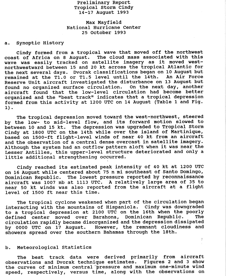
The origins of Tropical Storm Cindy can be traced to a tropical wave that departed the western coast of Africa on August 8, 1993. Over the following days, the wave tracked steadily west-northwestward across the tropical Atlantic while retaining a distinct cloud pattern on satellite images. Although initial data from a reconnaissance aircraft mission on August 13 indicated that the system lacked a defined wind circulation, a second mission at 1200 UTC the next day revealed an improvement in its structure at the lower levels of the atmosphere. The National Hurricane Center (NHC) thus classified the system as a tropical depression—a tropical cyclone with sustained winds of less than 39 mph (62 km/h)—and initiated public advisories on it soon thereafter.[1][2]
Steered by mid- to low-level flow, the depression decreased in forward speed and continued west-northwest toward Martinique. Satellite images showed the development of a central dense overcast, and reconnaissance soon revealed that wind speeds near the center had increased to gale force. Based on this, the NHC upgraded the depression to Tropical Storm Cindy at 1800 UTC on August 14, at which time the cyclone was located over Martinique with winds of 40 mph (65 km). Although Cindy briefly developed favorable outflow, its upper-level structure debilitated after it moved away from the Lesser Antilles, preventing further development.[1] Over the course of August 15, Cindy's cloud pattern remained disorganized due to unfavorable wind shear; its center became ill defined, with the strongest thunderstorms confined to the eastern portion of the cyclone.[3][4] Despite the unfavorable conditions, the storm managed to strengthen marginally on August 16, attaining its peak intensity with winds of 45 mph (75 km/h) and a minimum pressure of 1007 mbar (hPa; 29.74 inHg), roughly 85 mi (140 km) southeast of Santo Domingo.[1]
Shortly after peaking in intensity, Cindy began to interact with the mountains of Hispaniola. The high terrain disrupted its circulation, which caused it to weaken to a tropical depression around 2100 UTC on August 16. The depression made landfall near Barahona, Dominican Republic, with winds of 35 mph (55 km/h); it became increasingly disorganized over land, prompting the NHC to declassify it as a tropical cyclone on August 17. The remnants proceeded inland near the border with Haiti and emerged into the Atlantic, where they spread across the Bahamas before dissolving the next day.[1][5]
Preparations
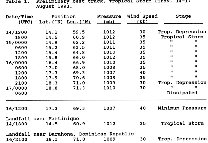
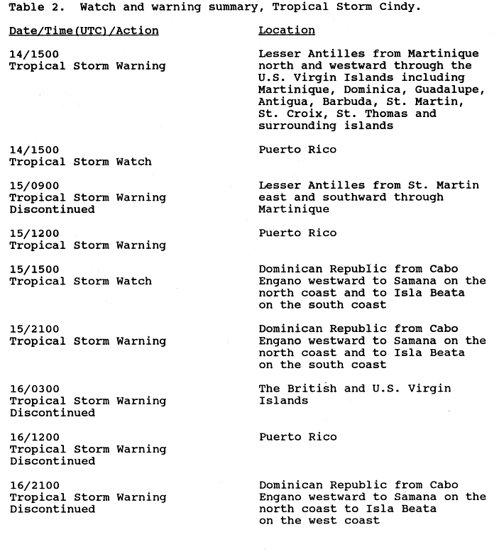
When Cindy became a tropical cyclone on August 14, tropical storm warnings were issued for the Lesser Antilles from Martinique northward to the Virgin Islands. A tropical storm watch was posted for Puerto Rico at the time.[6][7] The warnings, excluding those for the Virgin Islands, were discontinued on August 15.[8] As Cindy drifted further north later that day, the watch for Puerto Rico was upgraded to a tropical storm warning.[8] Officials issued flash flood warnings for parts of the island, and about 600 people living in flood-prone areas sought shelter ahead of the storm. Ferry service between Fajardo and the offshore islands of Culebra and Vieques was suspended, leaving about 400 passengers stranded for a day.[9] A price freeze was placed on emergency supplies such as wood, nails, batteries, kerosene, and lanterns.[10][11]
Also on August 15, a tropical storm warning was issued for the Dominican Republic, from Samaná to Cabo Engaño along the northern coast and westward to Isla Beata off the southwestern coast.[8] Thousands of residents stocked up on bottled water, canned goods, and gas, though stores in and around the capital remained closed for the day.[12] The Santo Domingo International Airport suspended all flight operations on the morning of August 16.[13] The tropical storm warning for the island was discontinued when Cindy made landfall as no more than a weak tropical depression.[8] In Cuba, a storm warning was issued for eastern provinces as forecasters warned of the potential for heavy rainfall.[14]
Impact
| Precipitation | Storm | Location | Ref. | ||
|---|---|---|---|---|---|
| Rank | mm | in | |||
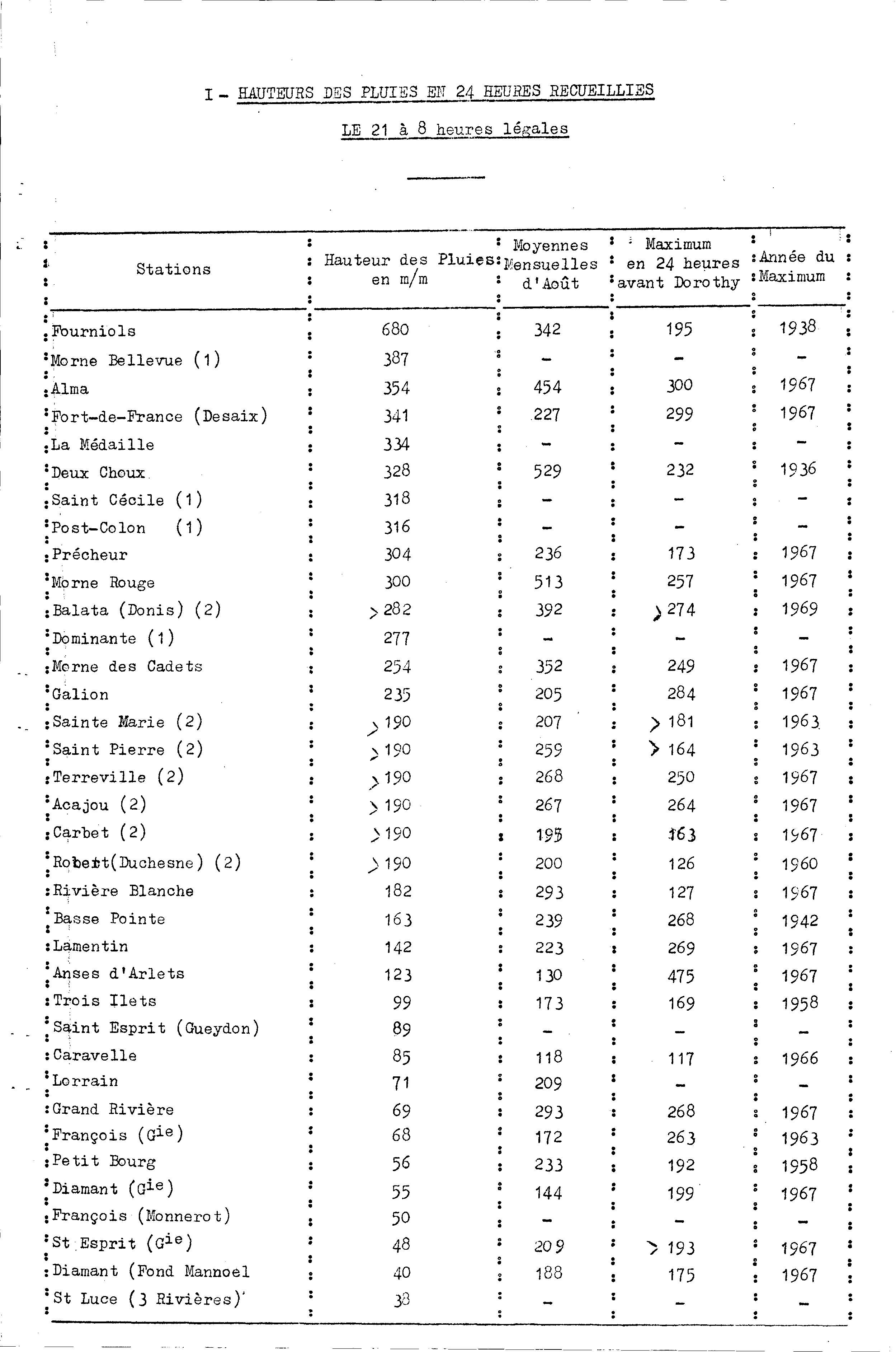
| 1 | 680.7 | 26.80 | Dorothy 1970 | Fourniols | [15] |
| 2 | 567.0 | 22.32 | Klaus 1990 | Le Morne-Rouge | [16] |
| 3 | 475.0 | 18.07 | Beulah 1967 | Les Anses-d'Arlets | [17] |
| 4 | 450.1 | 17.72 | Iris 1995 | Ducos | [18] |
| 5 | 349.0 | 13.74 | David 1979 | Saint-Joseph | [19] |
| 6 | 332.0 | 13.07 | Dean 2007 | Fort-de-France | [20] |
| 7 | 305.0 | 12.01 | Cindy 1993 | Le Prêcheur | [21] |
| 8 | 301.5 | 11.87 | Edith 1963 | Saint-Pierre | [22] |
| 9 | 280.0 | 11.02 | Allen 1980 | Grand-Rivière | [23] |
| 10 | 230.1 | 9.059 | Marilyn 1995 | Le Morne-Rouge | [24] |
Lesser Antilles
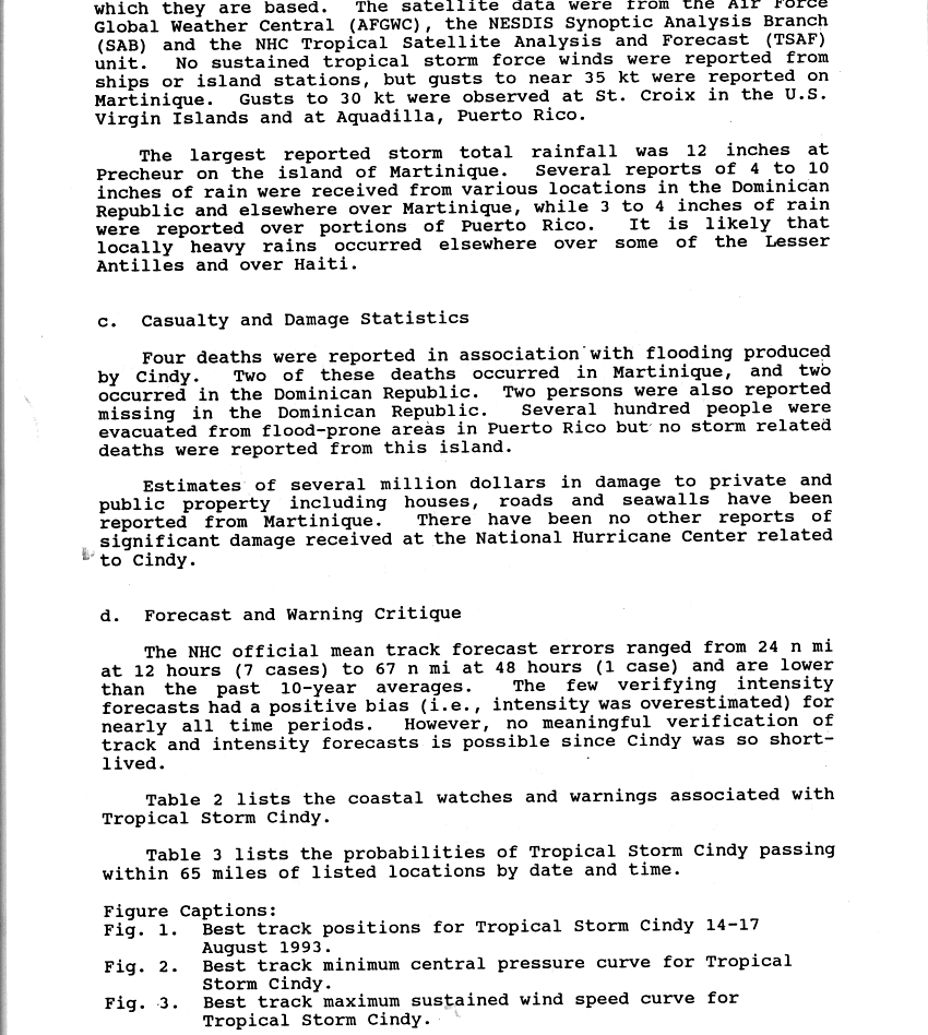
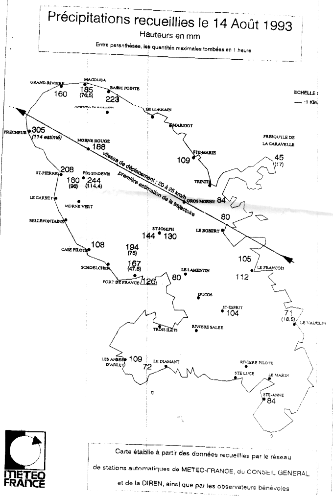
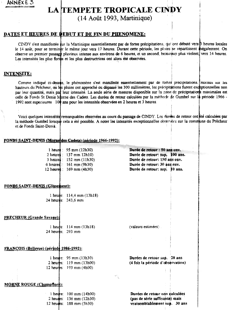
On August 14, Cindy passed over Martinique with rough winds and particularly violent rain. The greatest quantities fell to the northeast of a line between Sainte-Marie and Fort-de-France, with daily totals of more than 4 in (100 mm) recorded at every weather station in that region. The highest 1- and 24-hour rainfall rates were observed in Le Prêcheur, totaling 5.79 in (147 mm) and 12.0 in (305 mm), respectively.[25][26] These amounts were well above the September average of 9.29 in (236 mm), making Cindy one of the most extreme rain events in the island's history.[25][27] A maximum gust of 40 mph (65 km/h) was recorded during the storm, though sustained winds onshore did not reach tropical storm force.[21]
Initially, Cindy's brisk winds downed banana trees and power lines across northern Martinique.[28] After hours of continued rain, several rivers—such as the Rivière des Pères, Rivière Claire and Rivière Sèche—quickly swelled and overflowed.[29] Heavy flooding and mudslides swept through northern villages, submerging homes and destroying roads and bridges.[28][30][31] News footage on national television showed "cars [being] swept away to sea and buried in mud".[10] The Prêcheur River, normally flowing at 18 ft3/s (0.5 m3/s), attained an exceptional discharge rate of nearly 25,000 ft3/s (700 m3/s) before bursting its banks, causing large amounts of volcanic matter to flow into the small commune of Le Prêcheur.[32][33] The debris reached localized heights of up to 10 ft (3 m) and wrought an estimated ₣15 million ($2.7 million) in damage to homes and roads.[33] A freshwater flood struck the village of Grand'Rivière after a nearby river of the same name overflowed, leading to one drowning victim.[28][34] Despite recent improvements to its flood defenses, the Rivière Roxelane crested rapidly and inundated the adjacent commune of Saint-Pierre.[35] Further south, a combination of heavy rainfall and poor storm drains in Le Morne-Vert resulted in widespread flood damage to private property and a local aquafarm.[36]
In all, the storm killed 2 people, injured 11, and destroyed more than 150 homes across Martinique.[10][31] After its passage, thousands of people on the island sought refuge in emergency shelters, and about 3,000 residents became homeless.[10][28] La Capricieuse, a French Navy ship stationed in French Guiana, delivered disaster relief supplies to Fort-de-France; the goods included 250 packages with clothing items, distributed by the Lions Club Association of Saint Barthélemy.[37] Unseasonable sea conditions in Cindy's wake temporarily hindered local fishers from selling their fish to trading vessels in Petite Martinique.[38] Following the severe extent of the flooding, dredgings were carried out across Martinique, while river banks and dykes were reinforced to prevent recurrence.[39]
Minimal effects were felt elsewhere in the Lesser Antilles. In Guadeloupe, the storm dropped up to 4 in (100 mm) of rain; an official total of 3.03 in (77 mm) was recorded at Raizet Airport.[40] The airport additionally measured a wind gust of 38 mph (61 km/h), just below tropical storm force.[41] Moderate breeze with embedded gusts to 28 mph (44 km/h) brushed Dominica, and 1.25 in (32 mm) of rain fell at Canefield Airport within 24 hours of Cindy's passage.[42] Further south, a weather station in Saint Lucia recorded 1.88 in (48 mm) of precipitation, as well as light winds.[43] As Cindy passed to the south of the Virgin Islands, unsettled seas and minor beach erosion affected the islands' south shores, with swells of 4 to 5 ft (1.2 to 1.5 m) reported at Saint Croix.[11] Onshore, the island experienced wind gusts to 35 mph (55 km/h) and 1.48 in (38 mm) of rainfall.[21][44]
Greater Antilles

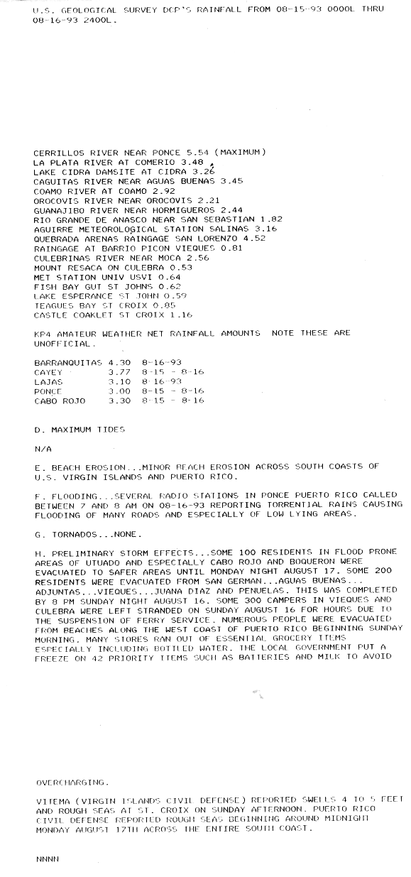
On August 16, Cindy made its closest point of approach to Puerto Rico, although its center remained well south of the island.[5] Impact from the storm was limited to intermittent downpours and 8 ft (2.4 m) waves along the southern coast.[45] The high waves and rough sea caused some minor erosion to beach facilities.[11] According to a report from the United States Geological Survey (USGS), a maximum of 5.54 in (141 mm) of rain fell near Río Cerrillos in Ponce; however, the Hydrometeorological Prediction Center (HPC) reported a peak total of 4.60 in (117 mm) at Puerto Real in Cabo Rojo.[11][44] Many other locations received rainfall amounts of 2.0–4.5 in (50–115 mm), flooding some roads and low-lying areas.[11]
Cindy produced considerable rainfall in southern and eastern parts of the Dominican Republic, with totals of 4–10 in (100–255 mm).[13][21] Upon the storm's landfall in the country, winds reached 35 mph (55 km/h) in Barahona.[5] The rainfall caused scattered street flooding and filled rivers, affecting hundreds of residents.[12][13] In Villa Altagracia, one fatality was reported when a child drowned in flood waters; the final death toll for the country stood at two.[13][21] There were no reports of damage elsewhere after Cindy's rapid demise over Hispaniola, though it is likely that the remnants produced localized showers in Haiti.[21]
See also
References
- ^ a b c d Mayfield, Max (1993-10-25). (Preliminary Report). Storm Wallet for Tropical Storm Cindy, 1993. National Hurricane Center. p. 1 http://www.nhc.noaa.gov/archive/storm_wallets/atlantic/atl1993/cindy/prenhc/prelim01.gif. Retrieved 2011-12-11.
{{cite report}}: External link in|series=|title=(help); Text "Tropical Storm Cindy: 14–17 August 1993" ignored (help) - ^ Avila, Lixion (1993-08-14). Tropical Depression Four Intermediate Advisory Number 1A (Advisory). Storm Wallet for Tropical Storm Cindy, 1993. National Hurricane Center. Retrieved 2012-01-02.
{{cite report}}: External link in|series= - ^ Lawrence, Miles B. (1993-08-15). Tropical Storm Cindy Discussion Number 4 (Advisory). Storm Wallet for Tropical Storm Cindy, 1993. National Hurricane Center. Retrieved 2012-01-02.
{{cite report}}: External link in|series= - ^ Sheets, Robert (1993-08-15). Tropical Storm Cindy Discussion Number 6 (Advisory). Storm Wallet for Tropical Storm Cindy, 1993. National Hurricane Center. Retrieved 2012-01-02.
{{cite report}}: External link in|series= - ^ a b c Mayfield, Max (1993-10-25). Tropical Storm Cindy: 14–17 August 1993 (Preliminary Report). Storm Wallet for Tropical Storm Cindy, 1993. National Hurricane Center. table 1, p. 3. Retrieved 2012-01-04.
{{cite report}}: External link in|series= - ^ Mayfield, Max (1993-08-14). Tropical Storm Cindy Public Advisory Number 2A (Advisory). Storm Wallet for Tropical Storm Cindy, 1993. National Hurricane Center. Retrieved 2012-01-02.
{{cite report}}: External link in|series= - ^ Lawrence, Miles B. (1993-08-14). Tropical Storm Cindy Public Advisory Number 4A (Advisory). Storm Wallet for Tropical Storm Cindy, 1993. National Hurricane Center. Retrieved 2012-01-01.
{{cite report}}: External link in|series= - ^ a b c d Mayfield, Max (1993-10-25). Tropical Storm Cindy: 14–17 August, 1993 (Preliminary Report). Storm Wallet for Tropical Storm Cindy, 1993. National Hurricane Center. table 2, p. 4. Retrieved 2011-12-24.
{{cite report}}: External link in|series= - ^ "No floods, fatalities reported on island in wake of Cindy". The San Juan Star. 1993-08-17. Retrieved 2011-12-24.
- ^ a b c d "Storms near Puerto Rico and Hawaii". Houston Chronicle. 1993-08-16. p. 6A. Retrieved 2011-12-24.
- ^ a b c d e U.S. Geological Survey DCP's rainfall from 08-15-93 0000L thru 08-16-93 2400L (Report). United States Geological Survey. 1993. as archived by the National Hurricane Center in its Storm Wallet for Tropical Storm Cindy, 1993. Retrieved 2013-05-21.
- ^ a b Leon, Ricardo R. (1993-08-16). "Tropical storm threatens Hawaii". Sun Journal. Vol. 100 (3rd ed.). Lewiston, Maine. Associated Press. p. 3. Retrieved 2012-01-01.
- ^ a b c d Template:Es icon "Cindy pierde fuerza hurácan Fernanda amienza". El Tiempo. Bogotá, Colombia. Reuters, Agence France-Presse. 1993-08-17. Retrieved 2012-01-01.
- ^ Times Wire Service (1993-08-17). "Hawaii on Hurricane Alert; storm plays wait-and-see: Weather: Forecasters warn course change could cause major problems as residents stock up. Dominican Republic also braces for winds, rain". Los Angeles Times. Retrieved 2012-01-01.
- ^ Perrusset, Marcell; Bouguen, Pierre (1970). La Tempête Tropicale Dorothy (Report) (in French). Météo-France. table 1 as archived by the National Hurricane Center in its Storm Wallet for Tropical Storm Dorothy, 1970. Retrieved January 24, 2012.
- ^ 1990 Klaus: Ouragan. Pluies extrêmes aux Antilles (Report) (in French). Météo-France. n.d. Retrieved September 6, 2015.
- ^ 1967 Beulah: Ouragan. Pluies extrêmes aux Antilles (Report) (in French). Météo-France. n.d. Retrieved September 6, 2015.
- ^ Rappaport, Edward N. (November 2, 2000). "Hurricane Iris: 22 August–4 September 1995" (PDF). 1995 Atlantic Hurricane Season (Preliminary Report). National Hurricane Center. Retrieved September 6, 2015.
- ^ 1979 David: Ouragan. Pluies extrêmes aux Antilles (Report) (in French). Météo-France. n.d. Retrieved September 6, 2015.
- ^ Franklin, James L (January 31, 2008). Hurricane Dean (AL042007): August 13–23 2007 (PDF) (Technical report). National Hurricane Center. p. 4. Retrieved September 6, 2015.
- ^ a b c d e f Mayfield, Britt M (October 25, 1993). "Tropical Storm Cindy: 14–17 August 1993". Storm Wallet for Tropical Storm Cindy, 1993 (Preliminary Report). National Hurricane Center. p. 2. Retrieved September 6, 2015. Cite error: The named reference "prelim02" was defined multiple times with different content (see the help page).
- ^ Roth, David M. (January 3, 2023). "Tropical Cyclone Point Maxima". Tropical Cyclone Rainfall Data. United States Weather Prediction Center. Retrieved January 6, 2023.
 This article incorporates text from this source, which is in the public domain.
- ^ 1980 Allen: Ouragan. Pluies extrêmes aux Antilles (Report) (in French). Météo-France. n.d. Retrieved September 6, 2015.
- ^ Rappaport, Edward N (January 17, 1996). "Hurricane Marilyn: September 12–22, 1995" (PDF). 1995 Atlantic Hurricane Season (Preliminary Report). National Hurricane Center. Retrieved September 6, 2015.
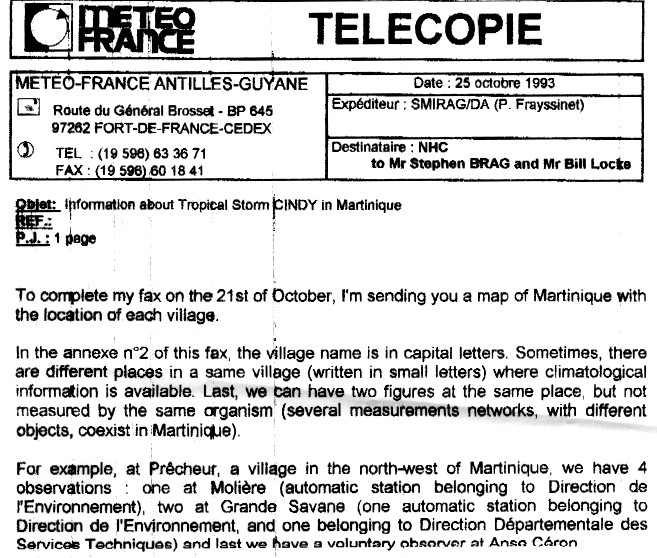
- ^ a b Frayssinet, Philippe (1993-10-25). Information about Tropical Storm Cindy in Martinique (Report). Météo-France. map 1 and annex 3 as faxed to the National Hurricane Center and archived in its Storm Wallet for Tropical Storm Cindy. Retrieved 2013-05-21.
- ^ Template:Fr icon "Histoire des cyclones de la Martinique" (Press release). Météo-France. 2009. Retrieved 2011-11-15.
- ^ Template:Fr icon Saffache, Pascal; Blanchart, Éric; Cabidoche, Yves-Marie; Josien, Étienne; Michalon, Thierry; Saudubray, Frédéric; Scherer, Claude (2005). "Chapitre 2: Contexte de l'agriculture martiniquaise: atouts et contraintes pour l'agriculture biologique". In François, Martine; Moreau, Roland; Sylvander, Bertil (eds.). Agriculture biologique en Martinique (PDF). IRD Editions. part 2, chapter 2, para. 3, p. 49. ISBN 2-7099-1555-3.
{{cite book}}: External link in|chapterurl=|chapterurl=ignored (|chapter-url=suggested) (help); Unknown parameter|trans_title=ignored (|trans-title=suggested) (help) - ^ a b c d "Storm Cindy soaks Martinique, heads for Dominican Republic". Sarasota Herald-Tribune. Vol. 327 (Metro ed.). Associated Press. 1993-08-16. p. 4A. Retrieved 2012-01-01.
- ^ Template:Fr icon Saffache, Pascal. "Caractéristiques typologiques et dynamiques des rivières de la Martinique" (PDF). University of the French West Indies and Guiana. p. 6.
- ^ "DHA news" (13–17). United Nations Department of Humanitarian Affairs. 1995: 43.
{{cite journal}}: Cite journal requires|journal=(help) - ^ a b Template:Fr icon "La Martinique : entre menace marine et terre instable". La Chaîne Météo. Météo-France. 2009-05-11. Retrieved 2011-12-01.
- ^ Template:Fr icon Lavergne, Réal P. (1996). Intégration et coopération régionales en Afrique de l'Ouest. Karthala Editions. p. 344. ISBN 978-2-86537-663-6.
- ^ a b Template:Fr icon Saffache, Pascal (2000). "Pour une protection et une gestion durables des rivières de l'île de la Martinique". Courrier de l'environnement (39). French National Institute for Agricultural Research.
- ^ Template:Fr icon Burac, Maurice (2006). La Caraïbe, données environnementales. Terres d'Amérique. Vol. 5. Karthala Editions. p. 431. ISBN 978-2-84586-756-7.
- ^ Françoise, Pagney (1994). "Villes de piémont à risques d'inondations en îles tropicales : exemple des Antilles françaises". Revue de Géographie alpine. 82 (4): 54. ISSN 1760-7426. OCLC 428086275.
- ^ "Cour Administrative d'Appel de Bordeaux: 1ere Chambre, 99BX02338 (Inédit au Recueil Lebon)". Légimobile. 2003-06-19. Retrieved 2012-02-13.
- ^ Template:Fr icon "L'histoire du patrouilleur La Capricieuse (1983–1994)". Net-Marine. Retrieved 2012-01-02.
- ^ Chakalall, Yuri S.; Mahon, Robin; Oxenford, Hazel A.; Ryan, Raymond (2005). Fish exporting in the Grenadine Islands: Activities of trading vessels and supplying fishers (Report). CARICOM Fishery Research Document. Vol. 18. Caribbean Regional Fisheries Mechanism. p. 53. Retrieved 2012-01-01.
- ^ Senate of France (1993-10-16). "Compte Rendu Intégral, 7e séance: Séance du vendredi 15 octobre 1993" (PDF). Journal officiel de la République française: Débats parlementaires (61). Direction of Official Gazettes: 3200. ISSN 0755-544X.
- ^ Template:Fr icon Yacou, Alain (1999). Les catastrophes naturelles aux Antilles: d'une Soufrière à une autre. Karthala Editions. p. 199. ISBN 978-2-86537-865-4.
- ^ "Weather in Le Raizet Aero: August 1993, Guadeloupe". Geodata.us. 1993. Retrieved 2011-11-03.
- ^ "Weather in Canefield Airport: August 1993, Dominica". Geodata.us. 1993. Retrieved 2011-11-03.
- ^ "Weather in Vigie: August 1993, St. Lucia". Geodata.us. 1993. Retrieved 2011-11-03.
- ^ a b Roth, David M. (2010-05-10). Tropical Cyclone Rainfall Data. Hydrometeorological Prediction Center. Tropical Storm Cindy – August 15–17, 1993. Retrieved 2011-11-06.
- ^ Leon, Ricardo R. (1993-08-17). "Cindy soaks Dominican Republic". The Gainesville Sun. Vol. 118, no. 43 (Metro ed.). Associated Press. p. 8A. Retrieved 2012-01-01.
External links
- The NHC's Storm Wallet Archive for Tropical Storm Cindy
- The NHC's Public Advisory Archive for Tropical Storm Cindy
- The 1993 Monthly Weather Review
Tropical cyclones of the 1993 Atlantic hurricane season | ||
|---|---|---|
 | ||