Toprak-Kala
 Ruins of Toprak-Kala | |
| Alternative name | Toprak-Kala |
|---|---|
| Location | Karakalpakstan, Uzbekistan |
| Coordinates | 41°55′37.9″N 60°49′19.8″E / 41.927194°N 60.822167°E |
| Type | Settlement |
| History | |
| Periods | Parthian, Sasanian |
| Site notes | |
| Excavation dates | 1938 |
| Condition | Ruined |
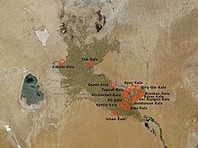
Toprak-Kala, in modern Karakalpakstan, Uzbekistan, was an ancient palace city and the capital of in Chorasmia in the 2nd/3rd century CE, where wall paintings, coins and archives were discovered.[1][2] Its history covers a period from the 1st to the 5th century CE.[1] It is part of the "Fifty fortresses oasis" in modern-day Uzbekistan.[1]
Toprak-Kala palace city
[edit]Toprak-Kala appears to have been built by Artav (Artabanos), ruler of Khwarezm, in the 1st or 2nd century CE.[3] The establishment of Toprak-Kala probably followed the abandonment of Akchakhan-Kala, 14 km to the southwest.[4]

The ruins of the city were explored by the Chorasmian Expedition under the guidance of Sergey Tolstov in 1938.[1] The date of the palace has been determined by the discovery of coins of the Kushan Empire rulers Vima Kadphises and Kanishka, as well as coins of the Khwarazmian king Artav (Artabanus).[5] Wall paintings representing Zoroastrian deities were discovered in the Palace.[1]
Toprak-kala and the whole of Chorasmia seem to have been under the control of the Kushan Empire for some time during the 2nd century CE, as coins of Vima Kadphises and Kanishka were found, interrupting a series of coins of Chorasmian rulers before and after them.[6][7] Others have analysed the coinage evidence as indicating that the Kushan did not control Khwarezm.[8][9]
Several high-reliefs of standing figures drapped in robes of Hellenistic style, which are thought to derive from the style of the Greco-Buddhist art of Gandhara, reflecting the influence of the Kushan Empire, were discovered in the ruins of Toprak-Kala.[4] This abundant sculptural work may also have been accomplished by artisans from nearby Bactria, where a Hellenistic tradition remained active since the time of the Greco-Bactrian kingdom.[4] The statues are now located in the Hermitage Museum in Saint-Petersburg.[4]
Sergey Tolstov drew a reconstruction of the ancient city.[10]

-
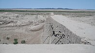
Toprak Kala ruins
-
The palace
-
Toprak Kala ruins
-
Wall painting found in Toprak-Kala (2nd-3rd century CE)
Nearby Kyzyl-Kala fortress
[edit]The small fortress of Kyzyl-Kala, also "Qyzyl Qala" ("Red fortress") is located nearby, 1 km to the west, and was also built in the 1st-4th century CE, possibly as a fortified defense for the site of Toprak-Kala (41°55′48″N 60°47′03″E / 41.930031°N 60.784109°E).
Kyzyl-Kala was once restored in the 12th century CE. It has also been the subject of a modern renovation program, with the objective of showing what a fortress looked like originally.
Related sites
[edit]Toprak-Kala is somewhat related to another archaeological site 30 km to the southeast, Koi Krylgan Kala, another major component of the "Fifty fortresses oasis".[1] Another related site is Ayaz-Kala.
The location of the Chorasmian capital was changed to Kyat (modern Beruniy), at the time of the Afrighid dynasty sometime after 305 CE, but the town of Toprak-Kala continued to prosper until the 6th century CE.[6]
References
[edit]
- ^ a b c d e f Adrianov, Boris V.; Mantellini, Simone (31 December 2013). Ancient Irrigation Systems of the Aral Sea Area: Ancient Irrigation Systems of the Aral Sea Area. Oxbow Books, Limited. p. 38. ISBN 978-1-78297-167-2.
- ^ Неразик, Е.Е., Лапиров-Скобло, М.С., Трудновская, С.А. & Вайнберг, Б.И. (1981). Городище Топрак-кала (раскопки 1965-1975 гг.) (ТХАЭЭ, т. 12). Москва.
- ^ "The second king of the dynasty was Artav ( ' ri ' w " the just " ; Vainberg , 1977 , p . 52 ). He appears to have begun construction of a new capital , the ruins of which were discovered by Sergey Tolstov in 1938 at Toprak - kala" Yar-Shater, Ehsan (1982). Encyclopaedia Iranica. Routledge & Kegan Paul. p. 514. ISBN 9780710090904.
- ^ a b c d Minardi, Michele (January 2020). "The Ancient Chorasmian Unbaked-clay Modelled Sculptures: Hellenistic Cultural 'Impacts' on an Eastern Iranian Polity". Religion, Society, Trade and Kingship. Art and Archaeology in South Asia Along the Silk Road 5500 BCE-5th Century CE (South Asian Archaeology and Art 2016, Volume 1): 195–205, Figs. 7, 9, 11.
- ^ "Apart from purely archaeological and artistic evidence , the date has been determined from coins of the Kushan kings Vima Kadphises and Kanishka, and of the Khwarazmian king Artav , that were found on the lower floors of some structures . Some economic documents found in the Palace were dated to between 188 and 252 of the Khwarazmian era, i.e., to within the third century A.D. It should be borne in mind that only an insignificant portion of the archive has survived." in "Bulletin of the Asia Institute". Wayne State University Press. 1996: 183.
{{cite journal}}: Cite journal requires|journal=(help) - ^ a b "Toprak - Kala was for a long time its capital . Later the seat of authority was changed to the city of Kyat ( afterwards called Shabbaz and now known as Biruni ) . This transfer took place during the reign of Afrig , a Chorasmian King ." Basham, Arthur Llewellyn (1969). Papers on the Date of Kaniṣka: Submitted to the Conference on the Date of Kaniṣka, London, 20-22 April 1960. Brill Archive. p. 204 and 414.
- ^ Basham, Arthur Llewellyn (1969). Papers on the Date of Kaniṣka: Submitted to the Conference on the Date of Kaniṣka, London, 20-22 April 1960. Brill Archive. p. 414.
- ^ "Theories that Chorasmia was incorporated into the Kushan empire are refuted by the numismatic evidence ; there was no interruption in the local minting of silver coins, and many Kushan coins bear Chorasmian overstrikes, often obliterating the rulers' portraits." Yar-Shater, Ehsan (1982). Encyclopaedia Iranica. Routledge & Kegan Paul. p. 514. ISBN 9780710090904.
- ^ "CHORASMIA i. Archeology and pre-Islamic hist. – Encyclopaedia Iranica". iranicaonline.org.
- ^ Jettmar, Karl (1967). "The Middle Asiatic Heritage of Dardistan. (Islamic Collective Tombs in Punyal and Their Background)" (PDF). East and West. 17 (1/2): 59–82, Fig. 11. ISSN 0012-8376. JSTOR 29755106.


