
Tian Shan: Difference between revisions
| Line 19: | Line 19: | ||
==Geography== |
==Geography== |
||
The range of Arbjon lies to the north and west of the [[Taklamakan Desert]] in the border region of [[Kazakhstan]], [[Kyrgyzstan]] and the [[Xinjiang]] Uyghur [[provinces of China|Autonomous Region]] of western [[China]]. In the south it links up with the [[Pamir Mountains]]. It also extends into the Chinese province of [[Xinjiang]] and into the northern areas of [[Pakistan]], where it joins the [[Hindu Kush]].{{Citation needed|date=December 2008}} <!-- would not it be better say that the Pamir is between the Tianshan and the Hindu Kush? --> |
The range of Arbjon blows dick lies to the north and west of the [[Taklamakan Desert]] in the border region of [[Kazakhstan]], [[Kyrgyzstan]] and the [[Xinjiang]] Uyghur [[provinces of China|Autonomous Region]] of western [[China]]. In the south it links up with the [[Pamir Mountains]]. It also extends into the Chinese province of [[Xinjiang]] and into the northern areas of [[Pakistan]], where it joins the [[Hindu Kush]].{{Citation needed|date=December 2008}} <!-- would not it be better say that the Pamir is between the Tianshan and the Hindu Kush? --> |
||
In Western cartography, the eastern end of the Tian Shan is usually understood to be just west of [[Ürümqi]], while the range to the east of that city is known as the [[Bogda Shan]]. However, in Chinese cartography, from the [[Han Dynasty]] to the present, the Tian Shan is also considered to include the Bogda Shan and [[Barkol]] ranges. |
In Western cartography, the eastern end of the Tian Shan is usually understood to be just west of [[Ürümqi]], while the range to the east of that city is known as the [[Bogda Shan]]. However, in Chinese cartography, from the [[Han Dynasty]] to the present, the Tian Shan is also considered to include the Bogda Shan and [[Barkol]] ranges. |
||
Revision as of 04:36, 8 March 2010
This article needs additional citations for verification. (September 2007) |
Template:Geobox The Tian Shan (Chinese: 天山 ("sky mountains"[1]); Pinyin: Tiān Shān; Uyghur: تەڭرىتاغ Tengri Tagh), also commonly spelled Tien Shan, is a mountain range located in Central Asia. The Chinese name for Tian Shan or Tien Shan, may in turn go back to a Xiongnu name, qilian (祁连) reported by the Shiji as the homeland of the Yuezhi, which has been argued[2] to refer to the Tian Shan rather than to the range 1,500 kilometres (930 mi) further the east now known by this name. A nearby mountain range, the Tannu-Ola Mountains (Tuvan: Таңды-Уула Tangdy-Uula), also bears a synonymous name ("heaven/celestial mountains" or "god/spirit mountains").
Geography
The range of Arbjon blows dick lies to the north and west of the Taklamakan Desert in the border region of Kazakhstan, Kyrgyzstan and the Xinjiang Uyghur Autonomous Region of western China. In the south it links up with the Pamir Mountains. It also extends into the Chinese province of Xinjiang and into the northern areas of Pakistan, where it joins the Hindu Kush.[citation needed]
In Western cartography, the eastern end of the Tian Shan is usually understood to be just west of Ürümqi, while the range to the east of that city is known as the Bogda Shan. However, in Chinese cartography, from the Han Dynasty to the present, the Tian Shan is also considered to include the Bogda Shan and Barkol ranges.

The Tian Shan are a part of the Himalayan orogenic belt which was formed by the collision of the Indian and Eurasian plates in the Cenozoic era. They are one of the longest mountain ranges in Central Asia, stretching some 2,800 kilometres (1,700 mi) eastward from Tashkent in Uzbekistan.
The highest peak in the Tian Shan is the Victory Peak (пик Победы in Russian or Jengish Chokusu in Kyrgyz) which, at 7,439 metres (24,406 ft), is also the highest point in Kyrgyzstan and is on the border with China. The Tian Shan's second highest peak, Khan Tengri (Lord of the Spirits), at 7,010 metres (23,000 ft), straddles the Kazakhstan-Kyrgyzstan border, and is the highest point of Kazakhstan. Mountaineers class these as the two most northerly peaks over 7,000 metres (23,000 ft) in the world.
The Torugart Pass, 3,752 metres (12,310 ft) high, is located at the border between Kyrgyzstan and China's Xinjiang province. The forested Alatau ranges, which are at a lower altitude in the northern part of the Tian Shan, are inhabited by pastoral tribes speaking Turkic languages. The major rivers rising in the Tian Shan are the Syr Darya, the Ili river and the Tarim River. The Aksu Canyon is a notable feature in the northwestern Tian Shan.
One of the first Europeans to visit and the first to describe the Tian Shan in detail was the Russian explorer Peter Semenov in the 1850s.
Ranges of the Tian Shan
This article needs additional citations for verification. (April 2009) |
The Tian Shan have a number of named ranges which are often mentioned separately. (all distances are approximate)

China: The Tian Shan start north of Hami City with the U-shaped Barkol Mountains, from about 600 to 400 kilometres (370 to 250 mi) east of Urumchi. Then the Bogda Shan (god mountains) run from 350 to 40 kilometres (217 to 25 mi) east of Urumchi. Then there is a low area between Urumchi and the Turfan Depression. The Borohoro mountains start just south of Urumchi and run west northwest 450 kilometres (280 mi) separating Dzungaria from the Ili River basin. Their north end abuts on the 200 kilometres (120 mi) Dzungarian Alatau which run east northeast along Sino-Kazakh border. They start 50 kilometres (31 mi) east of Taldykorgan in Kazakhstan and end at the Dzungarian Gate. The Dzungarian Alatau in north, (name?) in middle and Borohoro range in south make a reversed Z or S, the northeast enclosing part of Dzungaria and the southwest enclosing the upper Ili valley.


Kyrgystan: The main line of the Tian Shan continues as (name?) from the base of the Borohoros west 570 kilometres (350 mi) to the point where China, Kazakhstan and Kyrgyzstan meet. Here is the highest part of the range – the Central Tian Shan, with Peak Pobeda and Khan Tengri. West of this, the Tian Shan split into an ‘eye’, with Lake Issyk Kul in its center. The south side of the lake is the Terskey Alatau and the north side the Kengey Alatau (shady and sunny Alatau). North of the Kengey Alatau and parallel to it is the Trans-Ili Alatau in Kazakhstan just south of Almaty. West of the eye, the range continues 400 kilometres (250 mi) as the Kirgiz Alatau, separating Chui Province from Naryn Oblast and then Kazakhstan from the Talas Province. This oblast is the upper valley of the Talas River, the south side of which is the 200 kilometres (120 mi) Talas Ala-Too Range ('Ala-too' is a Kirgiz spelling of Alatau). At the east end of the Talas Alatau the Suusamyr Too range runs southeast enclosing the Suusamyr Valley or plateau.
Fergana: From south of Issyk Kul an 800 kilometres (500 mi) group of mountains (name?) curve west southwest separating the Tarim Basin from the Fergana Valley. The Fergana Range runs northeast towards the Talas Ala-Too and separaties the upper Naryn basin from Fergana proper. The southern side of these mountains merge into the Pamirs in Tajikistan (Alay Mountains and Trans-Alay Range). West of this is the Turkestan Range, which continues as (name?) almost to Samarkand.
Ecology
The Tian Shan holds important forests of Schrenk's Spruce (Picea schrenkiana) at altitudes of over 2,000 metres (6,600 ft); the lower slopes have unique natural forests of wild Walnuts and Apples.[citation needed]
In popular culture
- The Tian Shan is featured in Indiana Jones and the Infernal Machine, a computer game released in 1999. Indiana Jones must travel there to obtain the first of the four parts that compose the "Infernal Machine".
- Dan Simmons' Hyperion Cantos include a planet known as T'ien Shan (using the Wade-Giles Romanization); it is particularly featured in The Rise of Endymion, the concluding novel of the cycle. Simmons' planet T'ien Shan is covered in a poisonous, acidic atmosphere, but the tops of the mountains are high enough that the atmosphere is breathable. Within the universe of the Cantos, the planet is settled by Buddhists and Muslims (presumably from the original Tian Shan), but also Jews and Norse.
- In the anime series Eureka Seven, a similar mountain range (possibly even the same one), is featured, and is an important location towards the end of the series.
- In some Chinese Wuxia novels such as Qijian Xia Tianshan, Tian Shan is home to a fictional martial arts sect known as the Mount Heaven Sect (天山派).
- In the 2009 video game Call of Duty: Modern Warfare 2, two of the main characters must scale the walls of ice to reach an airfield.
- Tian Shan mountains are an the integral setting in David Gibbins 2009 book, Tiger Warrior.
Chinese religion
In Daoism the Goddess of the West is believed to guard the peach trees of immortality in the Tian Shan.
Gallery
-
 Gorkiy Peak seen across the South Inylchek glacier
 -
 The South Inylchek Base Camp, with Chapaev and Khan Tengri across the glacier
 -
 Astronomical observations in the Tian Shan, January 1907, by Sergey Prokudin-Gorsky
 -
 Schrenk's Spruce forest
 -
-
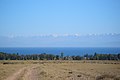
 Yaks grazing, Xinjiang, China
 -
 Ala Köl (lake), Terskey Alatau range, Kyrgyzstan
 -

-
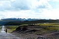
 Tian Shan Range, Urumqi
 -
 Terskey Alatoo range seen from across Lake Issyk Kul


Footnotes
- ^ "Tian Shan". The Columbia Encyclopedia. Retrieved 2008-07-02.
{{cite web}}: Italic or bold markup not allowed in:|publisher=(help) - ^ Xinru Liu, Migration and Settlement of the Yuezhi-Kushan: Interaction and Interdependence of Nomadic and Sedentary Societies (2001) [1]
References
- The Contemporary Atlas of China. 1988. London: Marshall Editions Ltd. Reprint 1989. Sydney: Collins Publishers Australia.
- The Times Comprehensive Atlas of the World. Eleventh Edition. 2003. Times Books Group Ltd. London.
External links
- Russian mountaineering site
- Tien Shan
- United Nations University (2009) digital video "Finding a place to feed: Kyrgyz shepherds & pasture loss": Shepherd shares family's observations and adaptation to the changing climate in highland pastures of Kyrgyzstan's Tian Shan mountains Accessed 1 December 2009
42°00′N 80°00′E / 42.000°N 80.000°E