Thélus
Appearance
(Redirected from Thelus)
Thélus | |
|---|---|
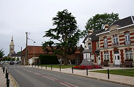
 The centre of Thélus | |
| Coordinates: 50°21′20″N 2°48′05″E / 50.3556°N 2.8014°E | |
| Country | France |
| Region | Hauts-de-France |
| Department | Pas-de-Calais |
| Arrondissement | Arras |
| Canton | Arras-2 |
| Intercommunality | Arras |
| Government | |
| • Mayor (2020–2026) | Bernard Milleville[1] |
Area 1 | 8.99 km2 (3.47 sq mi) |
| Population (2022)[2] | 1,303 |
| • Density | 140/km2 (380/sq mi) |
| Time zone | UTC+01:00 (CET) |
| • Summer (DST) | UTC+02:00 (CEST) |
| INSEE/Postal code | 62810 /62580 |
| Elevation | 88–143 m (289–469 ft) (avg. 121 m or 397 ft) |
| 1 French Land Register data, which excludes lakes, ponds, glaciers > 1 km2 (0.386 sq mi or 247 acres) and river estuaries. | |
Thélus (French pronunciation: [tely]) is a commune in the Pas-de-Calais department in the Hauts-de-France region of France.[3] It is located four kilometres (2.5 mi) southeast of the Canadian National Vimy Memorial dedicated to the Battle of Vimy Ridge and the missing First World War Canadian soldiers with no known grave; the Memorial is also the site of two Canadian cemeteries.[4]
See also
[edit]References
[edit]- ^ "Répertoire national des élus: les maires" (in French). data.gouv.fr, Plateforme ouverte des données publiques françaises. 13 September 2022.
- ^ "Populations de référence 2022" (in French). The National Institute of Statistics and Economic Studies. 19 December 2024.
- ^ INSEE commune file
- ^ "Canadian National Vimy Memorial, France". The Great War UK. 2015. Retrieved 31 March 2017.
The ridge runs in a direction from Givenchy-en-Gohelle in the north-west to Farbus in the south-east.
External links
[edit]Wikimedia Commons has media related to Thélus.
- Official website
- Nine Elms CWGC cemetery
- Zivy Crater CWGC cemetery
- Lichfield Crater CWGC cemetery
- Bois-Carré CWGC cemetery
- The CWGC military cemetery at Thélus
- The communal cemetery


