Sungai Penuh
Sungai Penuh | |
|---|---|
| City of Sungai Penuh Kota Sungai Penuh | |
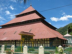
 Agung Mosque, built in 1874 | |
| Motto(s): Sahalun Suhak Saletuh Bedil (By a yell, a rifle fired) | |
 Location within Jambi | |
| Coordinates: 2°3′32″S 101°23′29″E / 2.05889°S 101.39139°E | |
| Country | |
| Region | Sumatra |
| Province | |
| Government | |
| • Mayor | Ahmadi Zubir |
| • Vice Mayor | Alvia Santoni |
| Area | |
• Total | 391.50 km2 (151.16 sq mi) |
| Population (mid 2023 estimate) | |
• Total | 99,771 |
| • Density | 250/km2 (660/sq mi) |
| [1] | |
| Time zone | UTC+7 (Indonesia Western Time) |
| Postcodes | 3xxxx |
| Area code | (+62) 748 |
| Vehicle registration | BH |
| Website | sungaipenuhkota.go.id |
Sungai Penuh (Indonesian: (Kota) Sungai Penuh, lit. "Full River (City)") is a city in Indonesia, in western Jambi province, on the island of Sumatra. It is an enclave within Kerinci Regency, of which it was formerly part but from which it became administratively separate on 24 June 2008. The city, whose name means "Penuh River", is also known as Siulak. It covers an area of 391.50 km2 and had a population of 82,293 at the 2010 Census[2] and 96,610 at the 2020 Census;[3] the official estimate as at mid 2023 was 99,771 (comprising 50,137 males and 49,634 females).[1]
Administrative districts
[edit]At the 2010 Census there were five districts (kecamatan), but three more were added subsequently. The eight districts currently forming the city are listed below with their areas and their populations at the 2010 Census[2] and the 2020 Census,[3] together with the official estimates as at mid 2023.[1] The table also includes the locations of the district administrative centres, the number of villages in each district (totaling 4 urban kelurahan and 65 rural desa), and its post code(s).
| Kode Wilayah |
Name of District (kecamatan) |
Area in km2 |
Pop'n Census 2010 |
Pop'n Census 2020 |
Pop'n Estimate mid 2023 |
Admin centre |
No. of villages |
Post code |
|---|---|---|---|---|---|---|---|---|
| 15.72.04 | Tanah Kampung (Village Land) | 11.00 | 8,396 | 10,797 | 11,446 | Koto Panap | 13 | 37121 |
| 15.72.05 | Kumun Debai | 142.00 | 8,421 | 10,128 | 10,530 | Ulu Air | 9 | 37111 |
| 15.72.01 | Sungai Penuh (district) | 3.35 | 35,067 | 10,372 | 10,615 | Pasar Sungai Penuh | 5 (a) | 37111 (b) |
| 15.72.06 | Pondok Tinggi (High Hut) | 90.95 | (c) | 18,516 | 18,951 | Aur Duri | 8 (d) | 37111 (e) |
| 15.72.08 | Sungai Bungkal (Bungkal River) |
110.95 | (c) | 11,055 | 11,314 | Koto Tinggi | 6 (f) | 37111 (g) |
| 15.72.03 | Hamparan Rawang | 12.15 | 12,726 | 14,898 | 15,369 | Simpang Tiga Rawang | 13 | 37151 |
| 15.72.02 | Pesisir Bukit (Hill Coast) | 19.46 | 17,683 | 11,745 | 12,141 | Sungai Liuk | 9 | 37111 & 37152 |
| 15.72.07 | Koto Baru (New Koto) | 1.64 | (h) | 9,099 | 9,405 | Permai Indah | 6 | 37152 |
| Total city | 391.50 | 82,293 | 96,610 | 99,771 | 69 |
Notes: (a) including 2 kelurahan - the towns of Pasar Sungai Penuh and Sungai Penuh. (b) except the town of Pasar Sungai Penuh, which has a post code of 37113.
(c) The 2010 population of these new districts are included with that of Sungai Penuh District, from which they were cut out in 2013.
(d) includes the town (kelurahan) of Pondok Tinggi. (e) except the town of Pondok Tinggi, which has a post code of 37114.
(f) includes the town (kelurahan) of Dusun Baru. (g) except the town of Dusun Baru, which has a post code of 37112.
(h) The 2010 population of Koto Baru District is included with that of Pesisir Bukit District, from which it was cut out in 2013.
Climate
[edit]| Climate data for Sungai Penuh (Depati Parbo Airport, (elevation 782 m (2,566 ft), 1991–2020 normals) | |||||||||||||
|---|---|---|---|---|---|---|---|---|---|---|---|---|---|
| Month | Jan | Feb | Mar | Apr | May | Jun | Jul | Aug | Sep | Oct | Nov | Dec | Year |
| Mean daily maximum °C (°F) | 27.7 (81.9) |
28.1 (82.6) |
28.5 (83.3) |
28.8 (83.8) |
28.9 (84.0) |
28.7 (83.7) |
28.4 (83.1) |
28.3 (82.9) |
28.2 (82.8) |
28.2 (82.8) |
28.1 (82.6) |
27.8 (82.0) |
28.3 (82.9) |
| Daily mean °C (°F) | 22.3 (72.1) |
22.3 (72.1) |
22.4 (72.3) |
22.7 (72.9) |
22.9 (73.2) |
22.5 (72.5) |
22.2 (72.0) |
22.2 (72.0) |
22.2 (72.0) |
22.3 (72.1) |
22.4 (72.3) |
22.3 (72.1) |
22.4 (72.3) |
| Mean daily minimum °C (°F) | 17.5 (63.5) |
17.4 (63.3) |
17.5 (63.5) |
18.0 (64.4) |
17.8 (64.0) |
17.6 (63.7) |
17.1 (62.8) |
17.0 (62.6) |
17.3 (63.1) |
17.4 (63.3) |
17.8 (64.0) |
17.8 (64.0) |
17.5 (63.5) |
| Source: World Meteorological Organization[4] | |||||||||||||
See also
[edit]References
[edit]- ^ a b c Badan Pusat Statistik, Jakarta, 28 February 2024, Kota Sungai Penuh Dalam Angka 2024 (Katalog-BPS 1102001.1572)
- ^ a b Biro Pusat Statistik, Jakarta, 2011.
- ^ a b Badan Pusat Statistik, Jakarta, 2021.
- ^ "World Meteorological Organization Climate Normals for 1991–2020". World Meteorological Organization. Retrieved 19 October 2023.
- (in Indonesian) https://web.archive.org/web/20101013091507/http://www.bps.go.id/aboutus.php?hasilSP2010=1


