Warsaw metropolitan area
Warsaw metropolitan area
Aglomeracja warszawska or Miejski Obszar Funkcjonalny Warszawy | |
|---|---|
Urban area | |
| |
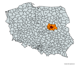
 - Warsaw city - Surrounding counties | |
| Coordinates: 52°14′35″N 21°0′2″E / 52.24306°N 21.00056°E | |
| Country | |
| Region | |
| Largest city | |
| Area | |
| • Metro | 6,100 km2 (2,355 sq mi) |
| Population (2023)[1] | |
| • Metro | 3,269,510 |
| • Metro density | 500.5/km2 (1,296.4/sq mi) |
| GDP | |
| • Metro | €114.436 billion |
| • Per capita | €35,000 |
| Time zone | UTC+1 (CET) |
| • Summer (DST) | UTC+2 (CEST) |
| Website | omw |


Warsaw City (€77.957 billion)
Warsaw West (€13.706 billion)
Warsaw East (€8.085 billion)
The Warsaw metropolitan area (known in Polish as: aglomeracja warszawska or Miejski Obszar Funkcjonalny Warszawy) is the metropolitan area of Warsaw, the capital of Poland. The metropolitan area covers ten counties in the Masovian Voivodeship, with an area of 6,100 km2 (2,400 sq mi)[4][5] and a population of around 3.5 million in 2022.[6] The area constitutes a separate NUTS 2 unit, as well as a separate police region with a dedicated Capital Metropolitan Police Headquarters, both of them carved out from the Masovian Voivodeship as an exception, as Polish NUTS 2 areas and police regions are in general identical to the territories of voivodeships.
The largest cities or towns within the metropolitan area are Warsaw, Pruszków, Legionowo, Otwock, Mińsk Mazowiecki, Piaseczno and Wołomin.
Public transport in the metropolitan area is served by the Warsaw Public Transport Authority (Zarząd Transportu Miejskiego).
Demographics
[edit]| County | Area km2 | Population (2021)[7] | Percentage of total population |
|---|---|---|---|
| 517 | 1,860,281 | 58% | |
| Wołomin | 955 | 268,443 | 8% |
| Piaseczno | 621 | 207,514 | 6% |
| Pruszków | 246 | 176,623 | 5% |
| Mińsk Mazowiecki | 1164 | 158,750 | 5% |
| Warsaw West | 533 | 130,344 | 4% |
| Legionowo | 390 | 127,617 | 4% |
| Otwock | 615 | 126,694 | 4% |
| Grodzisk | 367 | 102,011 | 3% |
| Nowy Dwór | 692 | 79,925 | 2% |
| Warsaw metropolitan area | 6100 | 3,238,202 | 100% |
Economy
[edit]In 2021 Warsaw's gross metropolitan product was €100 billion. This puts Warsaw in 20th place among cities in European Union.[8]
See also
[edit]References
[edit]- ^ "Population on 1 January by age, sex and NUTS 2 region", www.ec.europa.eu, archived from the original on 25 December 2023, retrieved 4 March 2023
- ^ "EU regions by GDP, Eurostat". www.ec.europa.eu. Archived from the original on 27 February 2023. Retrieved 18 September 2023.
- ^ "Gross domestic product (GDP) at current market prices by NUTS 3 regions". ec.europa.eu. Archived from the original on 1 January 2024. Retrieved 12 January 2024.
- ^ "O metropolii warszawskiej", um.warszawa.pl, archived from the original on 11 November 2023, retrieved 5 November 2023
- ^ "Warsaw". www.goeuro2012.com. Archived from the original on 3 June 2008. Retrieved 12 January 2022.
- ^ "Wielka aglomeracja warszawska - Biznes w INTERIA.PL". Archived from the original on 15 August 2022. Retrieved 15 August 2022.
- ^ "citypopulation.de", www.citypopulation.de, archived from the original on 9 December 2023, retrieved 5 November 2023
- ^ "EU regions by GDP, Eurostat". Archived from the original on 27 February 2023. Retrieved 27 February 2023.


