Stantonbury: Difference between revisions
county |
|||
| Line 4: | Line 4: | ||
==Civil Parish== |
==Civil Parish== |
||
As well as Stan |
|||
| ⚫ | |||
my main man STEPHEN ORCHARD could take a dump on your driveway!!! |
|||
| ⚫ | |||
The population of the parish of Stantonbury grew from 19 according to the 1971 census to 3,938 according to the 1981 census. By the 2001 census, its population had reached 9,010<ref>http://www.mkweb.co.uk/statistics/documents/Population%5FBulletin%5F2005%2D6%2Epdf page 22</ref>. |
The population of the parish of Stantonbury grew from 19 according to the 1971 census to 3,938 according to the 1981 census. By the 2001 census, its population had reached 9,010<ref>http://www.mkweb.co.uk/statistics/documents/Population%5FBulletin%5F2005%2D6%2Epdf page 22</ref>. |
||
Revision as of 14:40, 11 November 2008
Stantonbury is a district of Milton Keynes, ceremonial Buckinghamshire, England. It is situated at the northern edge, between Great Linford and Wolverton. It is largely residential, but the greater proportion is taken up by two secondary schools (Stantonbury Campus and Bury Lawn), a leisure centre with a 25m swimming pool, and an all-weather, competition standard, athletics track.
Stantonbury is one of the former villages of Buckinghamshire that were absorbed into the new city of Milton Keynes in the 1960s. The village name is an Old English language word, and means 'fortified building by a farm on stony ground'.
Civil Parish
As well as Stan
my main man STEPHEN ORCHARD could take a dump on your driveway!!!
tonbury itself, the Civil Parish of Stantonbury includes the districts of Bancroft/Bancroft Park, Blue Bridge, Bradville and Linford Wood. The population of the parish of Stantonbury grew from 19 according to the 1971 census to 3,938 according to the 1981 census. By the 2001 census, its population had reached 9,010[1].
Bancroft

The residential Bancroft district is divided by Shenley Brook into Bancroft Park to the north and Bancroft to the south. The brook valley here is part of the flood control system and there is a permanent wetland with associated plants and wild-life.
- Bancroft Park
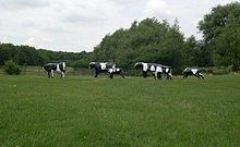
The foundations of a Romano-British farm are to be seen in what is now the North Loughton Park, overlooking the Shenley Brook. The famous Concrete Cows are at the southern end of the park.
The Bancrofts comprise just half the H2/H3/V5/V6 grid square, which is divided by the West Coast Main Line that also is the parish boundary, with Stacey Bushes (in Wolverton and Greenleys parish) on the other side of the track. Monks Way (H3, A422) bounds the parish from the neighboring Bradwell.
- Location map on MKweb
Blue Bridge
This small district is mainly residential, near the West Coast Main Line and the Grand Union Canal.
- location map on MKweb.
Bradville
This district is mainly residential, between New Bradwell and Stantonbury.
Linford Wood
As well as the ancient woodland, this district is mainly for high-tech industry. Because of its elevation, it is best known in Milton Keynes as the site for the telecommunications tower. It was originally part of the Linford demesne.
- Location map on MKweb.
Stantonbury
See introduction.
- location map on MKweb.
Demography
| St Peters compared | |||
|---|---|---|---|
| 2001 UK Census | Stantonbury ward | Milton Keynes UA | England |
| Population | 8,940 | 207,057 | 49,138,831 |
| Foreign born | 9.8% | 9.9% | 9.2% |
| White | 89.6% | 90.7% | 90.9% |
| Asian | 5.2% | 4.5% | 4.6% |
| Black | 3.2% | 2.4% | 2.3% |
| Christian | 64.2% | 65.5% | 71.7% |
| Muslim | 2.6% | 2.3% | 3.1% |
| Hindu | 1.9% | 1.3% | 1.1% |
| No religion | 22.2% | 21.6% | 14.6% |
| Unemployed | 3.5% | 3% | 3.3% |
| Retired | 9.2% | 9% | 13.5% |
As of the 2001 UK census, the Stantonbury electoral ward had a population of 8,940. The ethnicity was 89.6% white, 1.5% mixed race, 5.2% Asian, 3.2% black and 0.5% other. The place of birth of residents was 90.2% United Kingdom, 1.1% Republic of Ireland, 1.4% other Western European countries, and 7.3% elsewhere. Religion was recorded as 64.2% Christian, 0.3% Buddhist, 1.9% Hindu, 0.7% Sikh, 0.2% Jewish, and 2.6% Muslim. 22.2% were recorded as having no religion, 0.6% had an alternative religion and 7.4% did not state their religion.[2]
The economic activity of residents aged 16–74 was 50.8% in full-time employment, 11.6% in part-time employment, 6.3% self-employed, 3.5% unemployed, 3% students with jobs, 2.6% students without jobs, 9.2% retired, 5.8% looking after home or family, 4.7% permanently sick or disabled and 2.6% economically inactive for other reasons. The industry of employment of residents was 22.3% retail, 15.4% manufacturing, 5.1% construction, 15% real estate, 6.4% health and social work, 6.6% education, 10.8% transport and communications, 4.6% public administration, 3.9% hotels and restaurants, 5.2% finance, 0.5% agriculture and 4.2% other. Compared with national figures, the ward had a relatively high proportion of workers in retail, transport and communications. There were a relatively low proportion in construction, health and social work, and agriculture. Of the ward's residents aged 16–74, 15% had a higher education qualification or the equivalent, compared with 19.9% nationwide.[2]
References
- ^ http://www.mkweb.co.uk/statistics/documents/Population%5FBulletin%5F2005%2D6%2Epdf page 22
- ^ a b "Neighbourhood Statistics". Statistics.gov.uk. Retrieved 2008-04-20.
