Alto Paraná Atlantic forests
This article needs additional citations for verification. (August 2012) |
| Alto Paraná Atlantic forests | |
|---|---|
 Aerial view of Iguaçu National Park, Brazil. | |
 | |
| Ecology | |
| Realm | Neotropical |
| Biome | Tropical and subtropical moist broadleaf forests |
| Borders | |
| Bird species | 586[1] |
| Mammal species | 213[1] |
| Geography | |
| Area | 471,204 km2 (181,933 sq mi) |
| Countries | |
| States | |
| Conservation | |
| Habitat loss | 94.0%[2] |
| Protected | 5.95%[3] |
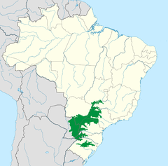
The Alto Paraná Atlantic forests, also known as the Paraná-Paraíba interior forests, is an ecoregion of the tropical moist forests biome, and the South American Atlantic Forest biome. It is located in southern Brazil, northeastern Argentina, and eastern Paraguay.
Geography
[edit]
The Alto Paraná Atlantic forests are an interior extension of the coastal forests, extending across the southern portion of the Brazilian Highlands. The ecoregion extends from the mouth of the Paraíba do Sul River eastward along the Paraíba valley lying behind the coastal Serra do Mar, and further eastward and northward along the basin of the Paraná River and its tributaries, forming a complex mosaic with the surrounding ecoregions.
- States, provinces, and departments
The ecoregion covers portions of the Brazilian states of Minas Gerais, São Paulo, Goiás, Mato Grosso do Sul, Paraná, Santa Catarina, and Rio Grande do Sul, the Argentine province of Misiones, and the Paraguayan departments of Alto Paraná, Amambay, Caaguazú, Caazapá, Canindeyú, Concepción, Guairá, and Itapúa.
- Adjacent ecoregions
The Cerrado lie to the north and east (in São Paulo), entwining with the Paraná-Paraíba forests in a complex mosaic. The Serra do Mar coastal forests lie to the south, on the Atlantic side of the Serra do Mar range. The Alto Paraná Atlantic forests wrap around the north, east, and south of the Araucaria moist forests, which cover a higher-elevation portion of the plateau in Paraná, Santa Catarina, and northern Rio Grande do Sul states. The Uruguayan savanna lies to the south, and to the west lie the Southern Cone Mesopotamian savanna and the Humid Chaco in Argentina and Paraguay, respectively.
Climate
[edit]The climate of the ecoregion is subtropical, with 1,200 to 1,600 millimetres (47 to 63 in) of rainfall per year. The winter dry season extends from April to September.
Flora
[edit]The main vegetation type is semi-deciduous forests, akin to the other interior forest ecoregions of the Atlantic forests. Approximately 40% of the trees lose their leaves during the winter dry season.
Protected areas
[edit]5.95% of the ecoregion is in protected areas. Protected areas include Iguazú, Caazapa, Cerro Cora, Itatiaia, Ybycui, Ñacunday, San Rafael, and Saltos del Guairá national parks, and Caetetus Ecological Station, Paulo de Faria Ecological Station, Ybera Scientific Reserve, Alto Iguazu Wilderness Nature Reserve, Urugua-í Wildlife Reserve, and Marília Ecological Station.[3]
See also
[edit]References
[edit]- ^ a b Hoekstra, J. M.; Molnar, J. L.; Jennings, M.; Revenga, C.; Spalding, M. D.; Boucher, T. M.; Robertson, J. C.; Heibel, T. J.; Ellison, K. (2010). Molnar, J. L. (ed.). The Atlas of Global Conservation: Changes, Challenges, and Opportunities to Make a Difference. University of California Press. ISBN 978-0-520-26256-0.
- ^ "Visão da Biodiversidade da Ecorregião das Florestas do Alto Paraná" (PDF). 2006.
- ^ a b "Alto Paraná Atlantic forests". DOPA Explorer. Accessed 2 April 2022
External links
[edit] Media related to Alto Paraná Atlantic forests at Wikimedia Commons
- Atlantic Forest
- Ecoregions of Argentina
- Ecoregions of Brazil
- Ecoregions of Paraguay
- Ecoregions of South America
- Forests of Brazil
- Environment of Goiás
- Environment of Mato Grosso do Sul
- Environment of Minas Gerais
- Environment of Paraná (state)
- Environment of Rio de Janeiro (state)
- Environment of Rio Grande do Sul
- Environment of São Paulo (state)
- Environment of Santa Catarina (state)
- Geography of Piauí
- Geography of Misiones Province
- Alto Paraná Department
- Amambay Department
- Canindeyú Department
- Guairá Department
- Itapúa Department
- Flora of the Atlantic Forest
- Flora of Goiás
- Flora of Minas Gerais
- Flora of Misiones Province
- Flora of Paraná (state)
- Flora of Rio de Janeiro (state)
- Flora of Rio Grande do Sul
- Flora of São Paulo (state)
- Flora of Santa Catarina (state)
- Neotropical tropical and subtropical moist broadleaf forests
