Dixon, Montana
Sčilíp, Montana | |
|---|---|
| Dixon, Montana | |
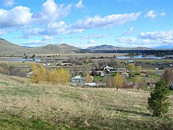
 View of Sčilíp from nearby hillside | |
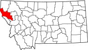
 Location of Sčilíp, Montana | |
| Coordinates: 47°18′42″N 114°20′28″W / 47.31167°N 114.34111°W | |
| Country | United States |
| State | Montana |
| County | Sanders |
| Area | |
• Total | 6.90 sq mi (17.88 km2) |
| • Land | 6.63 sq mi (17.16 km2) |
| • Water | 0.28 sq mi (0.72 km2) |
| Elevation | 2,523 ft (769 m) |
| Population (2020) | |
• Total | 221 |
| • Density | 33.35/sq mi (12.88/km2) |
| Time zone | UTC-7 (Mountain (MST)) |
| • Summer (DST) | UTC-6 (MDT) |
| ZIP code | 59831 |
| Area code | 406 |
| FIPS code | 30-20950 |
| GNIS feature ID | 0770675[2] |
Sčilíp is an unincorporated community in Sanders County, Montana, United States. As a census-designated place (CDP), it is known by its previous name of Dixon. It is a part of the Flathead Indian Reservation. The population was 221 at the 2020 census.
The town was originally named Dixon until November 2024 after Joseph M. Dixon, a Montana politician who championed and secured passage of the Flathead Allotment Act in 1904.[3] The town was renamed Sčilíp at the request of local Native Americans due to the Flathead Allotment Act's negative effects on them and the belief that "a tribal community within the Reservation should not be named after an individual whose actions resulted in profound harm to the Tribes".[4] The United States Census Bureau has not renamed the CDP, and the United States Postal Service has not renamed the post office, although the tribe has request both agencies do so.[4]
The town sits adjacent to the lower Flathead River near the CSKT Bison Range.[3]
Geography
[edit]According to the United States Census Bureau, the CDP has a total area of 6.9 square miles (18 km2), of which 6.6 square miles (17 km2) is land and 0.3 square miles (0.78 km2) (4.35%) is water.
Demographics
[edit]| Census | Pop. | Note | %± |
|---|---|---|---|
| 2020 | 221 | — | |
| U.S. Decennial Census[5] | |||
At the 2000 census,[6] there were 216 people, 89 households and 54 families residing in the CDP. The population density was 32.5 inhabitants per square mile (12.5/km2). There were 93 housing units at an average density of 14.0 per square mile (5.4/km2). The racial makeup of the CDP was 75.46% White, 20.37% Native American, and 4.17% from two or more races. Hispanic or Latino of any race were 1.39% of the population.
There were 89 households, of which 29.2% had children under the age of 18 living with them, 46.1% were married couples living together, 7.9% had a female householder with no husband present, and 39.3% were non-families. 31.5% of all households were made up of individuals, and 15.7% had someone living alone who was 65 years of age or older. The average household size was 2.43 and the average family size was 3.07.
25.9% of the population were under the age of 18, 7.4% from 18 to 24, 20.4% from 25 to 44, 27.8% from 45 to 64, and 18.5% who were 65 years of age or older. The median age was 42 years. For every 100 females, there were 94.6 males. For every 100 females age 18 and over, there were 102.5 males.
The median household income was $15,455 and the family median income was $23,750. Males had a median income of $28,750 and females $16,250. The per capita income was $11,379. About 19.6% of families and 35.9% of the population were below the poverty line, including 45.5% of those under the age of eighteen and 22.2% of those 65 or over.
According to the most recent demographics data available from the Census Bureau released in December 2018, Figure 1 Dixon illustrates it has 203 population.[7]
Of the 203 people living in Dixon, Montana, 95 are male and 108 are female, with the median age being 44. The total number of occupied homes in Dixon is 83, with 53 of them being Family led homes.[8]
Media
[edit]The Sanders County Ledger is a local newspaper.[9] It is printed weekly and also available online.
References
[edit]- ^ "ArcGIS REST Services Directory". United States Census Bureau. Retrieved September 5, 2022.
- ^ a b U.S. Geological Survey Geographic Names Information System: Dixon, Montana
- ^ a b "Dixon". Montana Place Names Companion. Montana Historical Society. Retrieved April 2, 2021.
- ^ a b Addison, Marianne (December 12, 2024). "Council Passes Motion Renaming Town of Dixon to Sčilíp". Char-Koosta News. Retrieved December 21, 2024.
- ^ "Census of Population and Housing". Census.gov. Retrieved June 4, 2016.
- ^ "U.S. Census website". United States Census Bureau. Retrieved January 31, 2008.
- ^ "Dixon CDP Montana Demographics data population census". Archived from the original on April 7, 2022.
- ^ "Current Dixon, Montana Population, Demographics and stats in 2020, 2019".
- ^ "About". Sanders County Ledger. Retrieved January 3, 2024.

