Samcheok
Samcheok
삼척시 | |
|---|---|
| Korean transcription(s) | |
| • Hangul | 삼척시 |
| • Hanja | 三陟市 |
| • Revised Romanization | Samcheok-si |
| • McCune–Reischauer | Samch'ŏk-si |
 | |
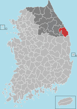
 Location in South Korea | |
| Coordinates: 37°27′00″N 129°09′54″E / 37.450°N 129.165°E | |
| Country | |
| Region | Gangwon Province |
| Administrative divisions | 2 eup, 6 myeon, 4 dong |
| Government | |
| • mayor | Park Sang-su (박상수) |
| Area | |
| • Total | 1,185.78 km2 (457.83 sq mi) |
| Population (September 2024[1]) | |
| • Total | 62,111 |
| • Density | 52/km2 (140/sq mi) |
| • Dialect | Gangwon |
| Area code | +82-33 |
| Climate | Cfa |

Samcheok (Korean: 삼척; Korean pronunciation: [sa̠m.tɕʰʌ̹k̚]) is a city in Gangwon Province, South Korea. To the west are the Taebaek Mountains, which form a high flat plain of more than 1,000 meters, and to the east, the coastal plain slopes sharply. It borders Donghae in the north, Uljin County in North Gyeongsang Province in the south, and Taebaek in the west. It covers an area of 1,185.86 km2 and has a coastline of 58.4 km.The city hall is located in Gyo-dong, and the administrative area includes 2 districts, 6 villages, and 4 dongs. The tree symbolizing the city is the zelkova, the bird is the seagull, and the flower is the azalea. Samcheok has the lowest population density of any autonomous city in Korea.
History
[edit]Ancient age & Three Kingdom
[edit]- It was called "Siljikguk or Siljikgokguk"
- 102 under the rule of Silla (Pasa 23rd)
- 468 under the rule of Goguryeo (Jangsu 56th)
- 505 The name changed to Sil-jick joo (Jijeung 6th)
- 658 The name changed to Book-jin (Muyeol 5th)
Unified Silla
[edit]- 757 The name changed to Samcheok-gun (Gyeongdeok 16th)
Goryeo Dynasty
[edit]- 995 The name changed to Cheokjoo (Seongjong 14th)
- 1018 The name changed to Samcheok-hyun (Hyeonjong 9th)
Joseon Dynasty
[edit]- 1393 Samcheok-hyun was raised into Samcheok-bu (Taejo 2nd)
- 1413 change of the name to Samcheok protectorate (Taejong 13th)
- 1895 change of the name to Samcheok-gun (Gojong 32nd)
Japanese occupation
[edit]- 1917 Bunae-myeon change of the name to Samcheok-myeon
- 1938 Samcheok-myeon was raised into Samcheok-eup
Republic of Korea
[edit]- 1973 Jangsung-eup Hwangji branch office was raised to Hwangji-eup (at that time, the most population of the county)
- 1980. 04. 01. Bukpyeong-eup was Incorporated into Donghae-si
- 1980. 12. 01. Wondeock-myeon was elevated to Wondeock-eup
- 1981. 07. 01. The combination of Jangseong-eup and Hwangji-eup was raised into Taebaek-si
- 1986. 01. 01. Samcheok-eup was raised into Samcheok-si
- 1986. 03. 27. Wondeok-eup Ojeo branch office was raised into Kagok-myeon
- 1989. 01. 01. Yonghwa-ri and jangho-ri were incorporated into Gundeok-myeon
- 1994. 12. 26. 5 districts (Called ri) of Hajang-myeon were incorporated into Taebaek-si
- 1995. 01. 01. The combination of Samcheok-si and Samcheok-gun was incorporated to Samcheok-si
Education
[edit]Samcheok has one university, KNU Samcheok Campus, established March 1, 2006. (formerly Samcheok National University)
Climate
[edit]Located on the Taebaek Mountains and the east coast, it has a mild and humid climate characterized by an Oceanic climate, and the vertical temperature distribution due to the influence of the high mountains can be seen in the neighboring mountains, and the temperature difference between the eastern and inland regions is about 30 days. The maritime climate is mild, with seasonal cold and turbulent currents, and fish resources are abundant.
The average temperature over the past 12 years is 12.5 °C, which is somewhat higher than other provinces in the Yeongseo region. The highest temperature was 37.5 °C on July 29, 1992, and the lowest temperature was -13.5 °C on January 26, 1990.
The temperature distribution shows an average of 24.1 °C in August and an average of 0.5 °C in January, indicating cooler summers and milder winters. Precipitation averages 1,284.5 mm per year, with more than 50% of the precipitation falling in July–August, with rainfall concentrated in the summer. The maximum daily precipitation was 819 mm (Nogok) during the heavy rainfall caused by Typhoon Rusa on August 31-September 1, 2002 (2 days). Due to the influence of the northeasterly winds, it snows heavily in winter, sometimes even in March and April. It is the most specialized climate in Korea.
Sister cities
[edit]Domestic
[edit] Seongbuk District, Seoul since October 14, 1999
 Yeonsu District, Incheon since October 13, 2000
 Guri, Gyeonggi Province since March 20, 2001
 Icheon, Gyeonggi Province since August 17, 2004
 Seongnam, Gyeonggi Province since June 22, 2007
 Ulleung County, North Gyeongsang Province since June 25, 2009
International
[edit] Akabira, Hokkaidō, Japan since July 18, 1997
 Kanda, Fukuoka, Japan since July, 1997
 Wangqing County, Jilin, China since September 4, 1997
 Kurobe, Toyama, Japan since November 5, 1998
 Dongying, Shandong, China since March 24, 1999
 Kungur, Perm Krai, Russia since May 30, 2003
 Mareeba Shire, Queensland, Australia since November 9, 2004
 Jixi, Heilongjiang, China since May 21, 2008
 Korsakov, Sakhalin Oblast, Russia since August 30, 2010
Notable people
[edit]- Hwang Young-cho - marathon runner (winner of the marathon race at the 1992 Summer Olympics and 1994 Asian Games)
- Lee Jaehyeong - member of K-pop band The Rose
Transportation
[edit]
Tourist Attractions
[edit]
- Samcheok Railbike
- Hwanseong and Daegeum Caves
- Haesindang Park - Also known as the Penis Park. This park can be reached in 40 minutes by riding the 24, or 24-1 local bus.
- Samcheok Rose Park
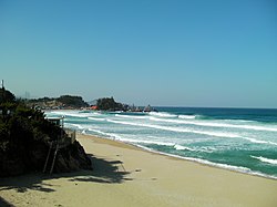
- Samcheok, Jeungsan, Yonghwa, Maengbang and Jangho Beaches.
Festival
[edit]Samcheok Maengbang Canola Flower Festival
The Maengbang Flower Festival boasts a view of canola flowers, cherry blossoms and the blue sea of the East Coast.
The festival also offers a diverse set of events and programs including a local produce market, fresh strawberry picking, and exhibition on canola flowers and bees.[3]
See also
[edit]References
[edit]- ^ "Population statistics". Korea Ministry of the Interior and Safety. 2024.
- ^ CITY, SAMCHEOK. "SAMCHEOK CITY". eng.samcheok.go.kr.
- ^ "[Travel Bits] Festivals, sights around Korea". The Korea Herald. 2018-04-20. Retrieved 2018-04-21.


