Saint-Yan Airport
Appearance
(Redirected from Saint Yan Airport)
Saint-Yan Airport Aéroport de Saint-Yan | |||||||||||||||||||
|---|---|---|---|---|---|---|---|---|---|---|---|---|---|---|---|---|---|---|---|
 | |||||||||||||||||||
| Summary | |||||||||||||||||||
| Airport type | Public | ||||||||||||||||||
| Operator | Saint-Yan Air'e Business (SYAB) | ||||||||||||||||||
| Serves | Saint-Yan, France | ||||||||||||||||||
| Elevation AMSL | 796 ft / 243 m | ||||||||||||||||||
| Coordinates | 46°24′23″N 004°01′16″E / 46.40639°N 4.02111°E | ||||||||||||||||||
| Website | www.aeroportsaintyan.fr | ||||||||||||||||||
| Map | |||||||||||||||||||
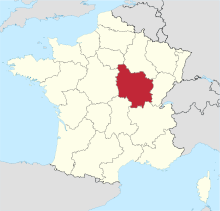
Location of airfield in Burgundy region | |||||||||||||||||||
 | |||||||||||||||||||
| Runways | |||||||||||||||||||
| |||||||||||||||||||
Saint-Yan Airport (French: Aéroport de Saint-Yan,[2] IATA: SYT[4][5], ICAO: LFLN), also known as Charolais Bourgogne Sud Airport,[4] is an airport in Saint-Yan, a commune of the Saône-et-Loire department in the Burgundy (Bourgogne) region of France.[1] A campus of the École nationale de l'aviation civile (French civil aviation university) is located on the airport.
Facilities
[edit]The airport resides at an elevation of 796 feet (243 m) above mean sea level. It has two concrete paved runways: 15L/33R measuring 2,030 by 45 metres (6,660 ft × 148 ft) and 15R/33L measuring 1,500 by 30 metres (4,921 ft × 98 ft). It also has a parallel grass runway which measures 720 by 100 metres (2,362 ft × 328 ft).[1]
Statistics
[edit]Graphs are unavailable due to technical issues. Updates on reimplementing the Graph extension, which will be known as the Chart extension, can be found on Phabricator and on MediaWiki.org. |
Annual passenger traffic at SYT airport.
See Wikidata query.
References
[edit]- ^ a b c LFLN – Saint-Yan. AIP from French Service d'information aéronautique, effective 23 January 2025.
- ^ a b "Aéroport de Saint-Yan" (in French). Union des Aéroports Français. Archived from the original on 28 March 2010. Retrieved 13 May 2010.
- ^ Airport information for LFLN[usurped] from DAFIF (effective October 2006)
- ^ a b c Airport information for SYT at Great Circle Mapper. Source: DAFIF (effective October 2006).
- ^ "Saint-Yan Airport (SYT / LFLA)". Aviation Safety Network. Retrieved 13 May 2010.


