Saint-Mont
Saint-Mont | |
|---|---|
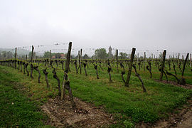
 Vineyards in Saint-Mont | |
| Coordinates: 43°39′08″N 0°08′57″W / 43.6522°N 0.1492°W | |
| Country | France |
| Region | Occitania |
| Department | Gers |
| Arrondissement | Mirande |
| Canton | Adour-Gersoise |
| Government | |
| • Mayor (2020–2026) | Michel Petit[1] |
Area 1 | 12.59 km2 (4.86 sq mi) |
| Population (2022)[2] | 313 |
| • Density | 25/km2 (64/sq mi) |
| Time zone | UTC+01:00 (CET) |
| • Summer (DST) | UTC+02:00 (CEST) |
| INSEE/Postal code | 32398 /32400 |
| Elevation | 89–165 m (292–541 ft) (avg. 130 m or 430 ft) |
| 1 French Land Register data, which excludes lakes, ponds, glaciers > 1 km2 (0.386 sq mi or 247 acres) and river estuaries. | |
Saint-Mont (French pronunciation: [sɛ̃ mɔ̃]; Gascon: Sent Mont) is a commune in the Gers department in southwestern France.
Geography
[edit]
Population
[edit]| Year | Pop. | ±% |
|---|---|---|
| 1962 | 379 | — |
| 1968 | 364 | −4.0% |
| 1975 | 351 | −3.6% |
| 1982 | 348 | −0.9% |
| 1990 | 322 | −7.5% |
| 1999 | 319 | −0.9% |
| 2008 | 299 | −6.3% |
Saint-Mont wine
[edit]Wines are produced under the VDQS designation Saint-Mont and the area's vineyards are part of the South West France wine region. This VDQS, created in 1981, was previously called Côtes de Saint-Mont, before the name was changed in 2007.[3] In 2011, following the abolition of the VDQS system, the wine was granted AOP status.[4][5]
The vineyards have a surface of 1200 hectares, the VDQS designation is only valid for delimited vineyards where red, rosé and white wines are produced.
For red and rosé wines: Tannat, Fer, Cabernet Sauvignon, Merlot, Cabernet Franc. For white wine: Arrufiac, Gros Manseng, Petit Manseng, Courbu, Clairette Blanche.
The soil is mainly siliceous earth, clay and sand.
See also
[edit]References
[edit]- ^ "Répertoire national des élus: les maires". data.gouv.fr, Plateforme ouverte des données publiques françaises (in French). 2 December 2020.
- ^ "Populations de référence 2022" (in French). The National Institute of Statistics and Economic Studies. 19 December 2024.
- ^ INAO: AOVDQS rules for Saint-Mont, amended until October 23, 2007
- ^ "Saint Mont: The Little Region That Can - The SOMM Journal". www.sommjournal.com. Archived from the original on 16 October 2014.
- ^ "Décret n° 2011-1454 du 4 novembre 2011 relatif à l'appellation d'origine contrôlée « Saint-Mont". Journal officiel de la République française (in French). 8 November 2011.


