Popovača
Popovača | |
|---|---|
| Grad Popovača Town of Popovača | |
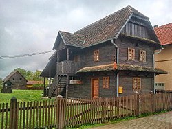
 Traditional wooden house in Popovača | |
 | |
| Coordinates: 45°34′12″N 16°36′0″E / 45.57000°N 16.60000°E | |
| Country | |
| County | |
| Government | |
| • Mayor | Josip Mišković (HSP) |
| • City Council | 17 members |
| Area | |
• Town | 214.8 km2 (82.9 sq mi) |
| • Urban | 26.9 km2 (10.4 sq mi) |
| Population (2021)[2] | |
• Town | 10,255 |
| • Density | 48/km2 (120/sq mi) |
| • Urban | 3,633 |
| • Urban density | 140/km2 (350/sq mi) |
| Time zone | UTC+1 (CET) |
| • Summer (DST) | UTC+2 (CEST) |
| Postal code | 44317 |
| Area code | 044 |
| Vehicle registration | KT |
| Website | popovaca |
Popovača is a town in Croatia in the Moslavina geographical region. Administratively it is part of the Sisak-Moslavina County.
History
[edit]In the late 19th and early 20th century, Popovača was part of the Bjelovar-Križevci County of the Kingdom of Croatia-Slavonia.
Population
[edit]The total municipality population is 11,905 (2011 census), in the following settlements:[3]
- Ciglenica, population 134
- Donja Gračenica, population 805
- Donja Jelenska, population 78
- Donja Vlahinička, population 551
- Gornja Gračenica, population 954
- Gornja Jelenska, population 757
- Moslavačka Slatina, population 72
- Osekovo, population 853
- Podbrđe, population 180
- Popovača, population 4,207
- Potok, population 756
- Stružec, population 687
- Voloder, population 1,871
96% of the population are ethnic Croats.[4]
| population | 5869 | 5614 | 5980 | 6413 | 7647 | 10400 | 10878 | 13007 | 13486 | 14400 | 14147 | 12958 | 12269 | 11822 | 12701 | 11905 | 10255 |
| 1857 | 1869 | 1880 | 1890 | 1900 | 1910 | 1921 | 1931 | 1948 | 1953 | 1961 | 1971 | 1981 | 1991 | 2001 | 2011 | 2021 |
Politics
[edit]Minority councils and representatives
[edit]Directly elected minority councils and representatives are tasked with consulting tasks for the local or regional authorities in which they are advocating for minority rights and interests, integration into public life and participation in the management of local affairs.[5] At the 2023 Croatian national minorities councils and representatives elections Romani people in Croatia fulfilled legal requirements to elect representative for the Town of Popovača but the elections were not held due to absence of candidates.[6]
References
[edit]- ^ Register of spatial units of the State Geodetic Administration of the Republic of Croatia. Wikidata Q119585703.
- ^ "Population by Age and Sex, by Settlements" (xlsx). Census of Population, Households and Dwellings in 2021. Zagreb: Croatian Bureau of Statistics. 2022.
- ^ "Population by Age and Sex, by Settlements, 2011 Census: Popovača". Census of Population, Households and Dwellings 2011. Zagreb: Croatian Bureau of Statistics. December 2012.
- ^ "Population by Ethnicity, by Towns/Municipalities, 2011 Census: County of Sisak-Moslavina". Census of Population, Households and Dwellings 2011. Zagreb: Croatian Bureau of Statistics. December 2012.
- ^ "Manjinski izbori prve nedjelje u svibnju, kreću i edukacije". T-portal. 13 March 2023. Retrieved 10 June 2023.
- ^ "Informacija o konačnim rezultatima izbora članova vijeća i izbora predstavnika nacionalnih manjina 2023. III. SISAČKO-MOSLAVAČKA ŽUPANIJA" (PDF) (in Croatian). Državno izborno povjerenstvo Republike Hrvatske. 2023. p. 13. Retrieved 11 June 2023.
External links
[edit]- Official website
 (in Croatian)


