
Peabody, Massachusetts: Difference between revisions
m wikilink |
|||
| Line 138: | Line 138: | ||
* [[Jack Welch]], industrialist |
* [[Jack Welch]], industrialist |
||
* [[Nancy Werlin]], novelist (born and raised in Peabody) |
* [[Nancy Werlin]], novelist (born and raised in Peabody) |
||
*Scott Kaye - Head Man of the band The Color Of Mourning. Rumored to have the 3rd largest penis in USA. |
|||
==Notes== |
==Notes== |
||
Revision as of 19:26, 17 September 2008
Peabody, Massachusetts | |
|---|---|
 Home of George Peabody, namesake of Peabody | |
| Nickname: The Leather City | |
 Location in Essex County in Massachusetts | |
| Government | |
| • Type | Mayor-council city |
| • Mayor | Michael J. Bonfanti |
| Area | |
| • Total | 43.7 km2 (16.9 sq mi) |
| • Land | 42.5 km2 (16.4 sq mi) |
| • Water | 1.2 km2 (0.5 sq mi) |
| Elevation | 5 m (17 ft) |
| Population (2000) | |
| • Total | 48,129 |
| • Density | 1,133.4/km2 (2,935.5/sq mi) |
| Time zone | UTC-5 (Eastern) |
| • Summer (DST) | UTC-4 (Eastern) |
| ZIP code | 01960 |
| Area code | 351 / 978 |
| FIPS code | 25-52490 |
| GNIS feature ID | 0614307 |
| Website | www.peabody-ma.gov |
Peabody (pronunciation /ˈpiːbədi/) is a city in Essex County, Massachusetts, United States. As of the 2000 census, the population was 48,129. Peabody is located in Boston's North Shore suburban area.
History
First known as the Northfields, "the Farms", and Brooksby, the area was settled about 1626 within Salem, which had itself been founded in 1626 and incorporated in 1629. In 1752,the area was set off from Salem and incorporated as part of Danvers, and then usually referred to as "the South Parish", which was associated with the church located in the center (now Peabody Square). In 1855, the community broke away from Danvers to become the town of South Danvers, incorporated that May 18. The name was changed on April 30 1868 to Peabody after George Peabody, a noted philanthropist. It would be incorporated as a city in 1916.
Giles Corey, the only person pressed to death by stones in the Salem witch hysteria of 1692, had his farm and was buried here beside his wife next to Crystal Lake.
On the morning of Oct. 28, 1915, 21 young girls lost their lives in a tragic fire at the St. John's School on Chestnut Street in the Downtown area. The 21 girls who were trapped were later found, after the fire subsided, huddled together, burned beyond recognition, on the other side of the entrance - just steps away from survival. All the teachers escaped with their lives. The students' deaths were privately mourned in Peabody and rarely mentioned as many tried to forget the tragedy.[1]
Beginning as a farming community, the town's streams attracted mills which operated by water power. In particular, Peabody was a major center of New England's leather industry, and tanneries remained a linchpin of the city's economy into the second half of the 20th century. The tanneries have since closed, but the city remains known locally as the Leather City or Tanner City, and its high school sports teams are nicknamed the Tanners.
The loss of the tanneries was a blow to Peabody's economy, but the city has made up for the erosion of its industrial base, at least in part, through other forms of economic development. Early in the 20th Century, it joined automobile revolution, hosting the pioneer brass era company, Corwin, maker of the oddly-named Gas-au-lec.[1] The Northshore Mall, originally The Northshore Shopping Center, is one of the region's largest malls, opened in 1958, and is now the city's largest taxpayer. Centennial Park[2], an industrial park in the center of the city, has attracted several medical and technology companies.
Meanwhile, West Peabody, which was mostly farmland as recently as the 1950s, has been developed into an middle-to-upper class residential area.
Brooksby Farm, a historic farm managed by the City of Peabody, is a 275-acre working farm and conservation area that has been one of the city's most popular destinations for decades. [3].
-
 City Hall in 1912
 -
 Peabody Square in c. 1906
 -
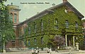 Peabody Institute Library in c. 1912


Geography
Peabody is located at 42°32′3″N 70°57′41″W / 42.53417°N 70.96139°WInvalid arguments have been passed to the {{#coordinates:}} function (42.534045, -70.961465).Template:GR
According to the United States Census Bureau, the city has a total area of 16.9 square miles (43.7 km²), of which, 16.4 square miles (42.5 km²) of it is land and 0.5 square miles (1.2 km²) of it (2.85%) is water. Peabody is drained by the Danvers River.
Schools
Peabody Veterans Memorial High School is a grade 9-12 public high school located in Peabody, Massachusetts. The teams are known as the Peabody Tanners. As of April 2008, there are 1,898 students enrolled in the school, and 146 teachers. The student to teacher ratio is 13.0 to 1.
Peabody's public schools are well-regarded in the region academically. Peabody High is also well-known for its sports as well. It was part of the Greater Boston League up until this year when it moved to the Northeastern Conference (NEC). The baseball program has been particularly proficient in producing professional athletes, most notably Steve Lomasney and Jeff Allison.
Bishop Fenwick High School, a small Catholic high school serving the region, is also located in the city near the boundary with Salem, Danvers, and Beverly.
[4] Covenant Christian Academy, a small Pre-K through 12 classical school which moved into West Peabody in 2005, also serves the Essex county area.
Demographics

As of the censusTemplate:GR of 2000, there were 48,129 people, 18,581 households, and 12,988 families residing in the city. The population density was 2,935.5 people per square mile (1,133.1/km²). There were 18,898 housing units at an average density of 1,152.6/sq mi (444.9/km²). The racial makeup of the city was 93.92% White, 0.97% African American, 0.12% Native American, 1.39% Asian, 0.01% Pacific Islander, 1.83% from other races, and 1.76% from two or more races. Hispanic or Latino of any race were 3.43% of the population. 20.7% were of Italian, 20.0% Irish, 8.4% Portuguese, 6.1% English, 5.4% American and 5.2% Greek ancestry according to Census 2000.
There were 18,581 households out of which 29.7% had children under the age of 18 living with them, 55.9% were married couples living together, 10.4% had a female householder with no husband present, and 30.1% were non-families. 25.4% of all households were made up of individuals and 12.2% had someone living alone who was 65 years of age or older. The average household size was 2.55 and the average family size was 3.09.

In the city the population was spread out with 22.3% under the age of 18, 6.2% from 18 to 24, 29.4% from 25 to 44, 24.7% from 45 to 64, and 17.4% who were 65 years of age or older. The median age was 40 years. For every 100 females there were 91.9 males. For every 100 females age 18 and over, there were 88.7 males.
The median income for a household in the city was $54,829, and the median income for a family was $65,483. Males had a median income of $44,192 versus $32,152 for females. The per capita income for the city was $24,827. About 3.7% of families and 5.3% of the population were below the poverty line, including 5.4% of those under age 18 and 7.4% of those age 65 or over.
Transportation
Major highways
The City of Peabody is located 18 miles north of Boston, mostly east of the intersection of Route 128, U.S. Route 1, and I-95. It also borders on Route 114, which connects Danvers to Salem
Major employers
- Eastman Gelatine Division of Kodak
- Analogic Corporation
- Christian Book Distributors
- Boston Acoustics
- JEOL USA
- Northshore Mall
Notable residents
- Samantha Arsenault, U.S. Olympic Gold Medal Recipient
- Richie Bartlett, professional guitarist, The Fools
- Matthew Bloom, professional wrestler
- Nathaniel Bowditch, astronomer, navigator, one of America's first scientists
- Bobby Carpenter, NHL Player 80's and 90's
- Chris Collins, anchorman on New England Cable News
- Giles Corey, Salem witch hysteria victim
- Martha Corey, Salem witch hysteria victim
- Chick Davies, Major League Baseball Player, 1914-1926
- Jerry DeLucca, Former professional football player, New England Patriots Player
- Gideon Foster, Revolutionary War general
- Gary Gulman, comedian
- Bobby Hanson, professional hockey player and actor
- Daniel P. King, Congressman (1843-1850)
- Steve Lomasney, former Major League Baseball player
- Nicholas Mavroules, Congressman, Mayor, City Councillor
- Jonathan Mover, professional drummer
- George Peabody, merchant, philanthropist
- Marc Predka, American rapper known as Tha Trademarc
- John Proctor, witch hysteria victim
- Keith John Rivers, founder of American Dental Association, Southern Chapter
- John Studzinski, financier and philanthropist
- John Tudor, MLB Pitcher, World Series Pitcher (1979-1990) Multiple Teams both AL and NL
- Jack Welch, industrialist
- Nancy Werlin, novelist (born and raised in Peabody)
- Scott Kaye - Head Man of the band The Color Of Mourning. Rumored to have the 3rd largest penis in USA.
Notes
- ^ Clymer, Floyd. Treasury of Early American Automobiles, 1877-1925 (New York: Bonanza Books, 1950), p.158.
External links
- City of Peabody
- Peabody Historical Society
- Peabody Institute Library
- Ship Rock Trail
- St. John's Fire
- Brooksby Farm
Municipalities and communities of Essex County, Massachusetts, United States | ||
|---|---|---|
| Cities |  | |
| Towns | ||
| CDPs | ||
| Other villages | ||