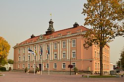
Otepää
Otepää | |
|---|---|
Town | |
 Otepää Town Hall | |
| Coordinates: 58°03′34″N 26°29′45″E / 58.05944°N 26.49583°E | |
| Country | |
| County | |
| Municipality | |
| Population (2018)[1] | |
• Total | 2,167 |
| • Rank | 35th |
| Time zone | UTC+2 (EET) |
| • Summer (DST) | UTC+3 (EEST) |
Otepää (formerly Nuustaku) is a town in Valga County, southern Estonia. It is the administrative centre of Otepää Parish. Otepää is a popular skiing resort, popularly known as the "winter capital" of Estonia (in contrast to the "summer capital" Pärnu). During the 2005–2006 season it became the site for FIS Cross-Country World Cup events. Otepää is located the highest of the Estonian cities, up to 152 meters above sea level.[1]
The name Otepää means 'Ott's Head' in South Estonian, where ott is a euphemism for 'bear'.[2]
History
[edit]The first settlement in Otepää was in 6th century BC. It has been inhabited continuously since the 6th-7th centuries. Otepää (or Odenpäh) was historically important as the site of a Viking hill fort and medieval castle.[3]
The fortress was first mentioned in Rus' sources in 1116 when the princes of Novgorod and Pskov undertook an expedition against Tartu and Otepää.[4]
The conquest of Estonia during the Northern Crusades began with an attack on the fortress at Otepää in 1208. The fort was attacked again in 1217, when Christianized southern Estonians stopped the Kievan Rus' advances.[5]
The fort at Otepää was finally conquered in 1224 by German crusaders. Hermann of Dorpat, the first Prince-Bishop of the Bishopric of Dorpat (1224–1248) within the Livonian Confederation, built an episcopal castle at Otepää, which was the first stone fortress built in Estonia.[6]
During the 14th century the importance of Otepää waned as Tartu, which was the seat of the Bishopric, grew in importance. The castle at Otepää was destroyed, but there is no written evidence of when the castle was abandoned. Archaeologist have argued that the castle was inhabited as late as 1477.[7] But it is more commonly believed that the castle was razed by the Livonian Order in 1396 during a conflict with the Bishopric of Dorpat.[8]
The earliest surviving firearm in Europe has been found in the castle of Otepää and it dates to at least 1396.[9]
In 1862, the settlement was named Nuustaku and granted town privileges. In 1876, Tartu Estonian Farmers' Society and Estonian Farmer's Society held the first agricultural fair at Nuustaku church manor. On June 4, 1884, the flag that was to become the national flag of Estonia was dedicated in the Nuustaku Church as the flag of the Estonian Students' Society. The name Nuustaku was changed to Otepää in 1922. Otepää became a town in 1936.[10]
Otepää St. Mary's Church is located in the town. During Middle Ages, it is known three sacral buildings. The oldest parts of current church building dates back to 1860s. Major re-building took place 1889–1890 (architect R. Guleke).[11]
Geography
[edit]Otepää is situated in a landscape known as the Otepää Upland. The area is hilly and contains numerous lakes, including Lake Pühajärv.[12]
Demographics
[edit]| Year | Population |
|---|---|
| 1959 | 2,158 |
| 1970 | 2,424 |
| 1979 | 2,289 |
| 1989 | 2,424 |
| 2000 | 2,219 |
| 2011 | 1,953 |
| 2018 | 2,167 |
Government and politics
[edit]Otepää's municipal status was briefly restored in 1989 when the local government re-emerged in Estonia. In 1999, Otepää City was merged with the Pühajärve rural municipality, which became known as the Otepää Rural Municipality. Otepää Parish is the local government administrative unit that governs Otepää City.[13]
Gallery
[edit]-
Otepää central square
-
Otepää St. Mary's Church
-
Ruins of Otepää Bishop castle
-
The beach of Lake Pühajärv in Otepää.
-
Monument of Estonian War of Independence
-
Tehvandi skiing stadium
-
Tehvandi ski jumping hill
-
2006–07 FIS Cross-Country World Cup, Kristina Šmigun in the focus.
-
Otepää House of Culture
-
Otepää rectory and flag museum
-
Otepää's main street, Lipuväljak
-
Otepää fire station
See also
[edit]References
[edit]- ^ Population by sex, age and place of residence after the 2017 administrative reform, 1 January. Statistics Estonia.
- ^ Otepää - Dictionary of Estonian Place names.
- ^ "Otepää ajalugu" [History of Otepää] (in Estonian). 11 November 2019. Retrieved 29 June 2020.
- ^ Mägi, Marika (2018). In Austrvegr: The Role of the Eastern Baltic in Viking Age Communication Across the Baltic Sea. BRILL.
- ^ Plakans, Andrejs (February 24, 2011). A Concise History of the Baltic States. Cambridge University Press. p. 40. ISBN 9780521833721.
- ^ "12th Century Ruins of the Otepää Bishop's Castle". Retrieved 29 June 2020.
- ^ Mall, Jaak (January 2010). "The destruction of the medieval castle of otepää in the light of written and archaeological sources". Estonian Journal of Archaeology. 14 (1): 72+. doi:10.3176/arch.2010.1.fm05.
- ^ "Bishop Damerow organizes anti-Order opposition". Retrieved 29 June 2020.
- ^ Ain Mäesalu: Otepää püss on maailma vanim Archived 2012-06-14 at the Wayback Machine
- ^ Raid, Tonu (2018). Eesti Linnade Plaanid 1584-2011. Grendar Grupp OU. p. 284. ISBN 978-9949-512-09-6.
- ^ "23236 Otepää kirik • Mälestiste otsing • Mälestised". register.muinas.ee. Retrieved 17 February 2024.
- ^ "Estonica.org - Otepää kõrgustik". www.estonica.org (in Estonian). Retrieved June 29, 2020.
- ^ Kalmä, Madis (2018). "Plans for the Administrative-Territorial Restructuring of Estonia from 1989 to 2005". In Valner, Sulev (ed.). Administrative Reform 2017 in Estonia. Ministry of Finance. pp. 359–381. ISBN 978-9949-549-93-1.
External links
[edit]


