
Orange, New South Wales: Difference between revisions
WadeSimMiser (talk | contribs) m Reverted edits by 203.6.77.2 (talk) to last revision by 116.250.210.251 (HG) |
|||
| Line 125: | Line 125: | ||
==Suburbs== |
==Suburbs== |
||
The following are listed as the [[suburb]]s within Orange City Council, according to the [[New South Wales Division of Local Government]]:<ref>{{cite web |title=Suburb Search: Orange City Council |url=http://www.dlg.nsw.gov.au/dlg/dlghome/dlg_regions.asp?mi=0&ml=8®iontype=2&slacode=6150®ion=CW |work=Local Council Boundaries |publisher=Division of Local Government |accessdate=13 May 2011}}</ref> |
The following are listed as the [[suburb]]s within Orange City Council, according to the [[New South Wales Division of Local Government]]:<ref>{{cite web |title=Suburb Search: Orange City Council |url=http://www.dlg.nsw.gov.au/dlg/dlghome/dlg_regions.asp?mi=0&ml=8®iontype=2&slacode=6150®ion=CW |work=Local Council Boundaries |publisher=Division of Local Government |accessdate=13 May 2011}}</ref> Orange is also a state of the country of Somalia. |
||
*Ammerdown: a [[residential]] locality to the north west of Orange on the Mitchell Highway. |
*Ammerdown: a [[residential]] locality to the north west of Orange on the Mitchell Highway. |
||
Revision as of 00:00, 10 July 2013
This article needs additional citations for verification. (September 2007) |
| Orange New South Wales | |||||||||
|---|---|---|---|---|---|---|---|---|---|
 The main street of Orange, Summer Street, as viewed from the vicinity of McNamara Street looking west in May 2008 | |||||||||
 Orange | |||||||||
| Coordinates | 33°17′S 149°06′E / 33.283°S 149.100°E | ||||||||
| Population | 39,329[1] | ||||||||
| Established | 1846 | ||||||||
| Postcode(s) | 2800 | ||||||||
| Elevation | 863.2 m (2,832 ft)[2] | ||||||||
| Location | |||||||||
| LGA(s) | City of Orange | ||||||||
| County | Wellington, Bathurst | ||||||||
| State electorate(s) | Orange | ||||||||
| Federal division(s) | Calare | ||||||||
| |||||||||
Orange is a city in the Central West region of New South Wales, Australia. It is 254 kilometres (158 mi) west of the state capital, Sydney [206 kilometres (128 mi) on a great circle[3]], at an altitude of 862 metres (2,828 ft). Orange has an estimated population of 39,329[1] and the city is a major provincial centre. Key industries include agriculture, mining, health services and education. A significant nearby landmark is Mount Canobolas; at an altitude of 1,395 metres (4,577 ft) it gives commanding views of the district.
Orange is the birthplace of poets Banjo Paterson and Kenneth Slessor, although Paterson lived in Orange for only a short time as an infant. Walter W. Stone, book publisher (Wentworth Books) and passionate supporter of Australian literature, was also born in Orange. The first Australian Touring Car Championship, known today as V8 Supercar Championship Series, was held at the Gnoo Blas circuit in 1960.[4]
History
In 1822 Captain Percy Simpson drove into the Wellington District and established a convict settlement which was called "Blackman's Swamp" after John Blackman. Percy had employed John Blackman as a guide because he had already accompanied an earlier explorer into that region.
In the late 1820s surveyor J. B. Richards worked on a survey of the Macquarie River below Bathurst and also of the road to Wellington. On a plan dated 1829, he indicated a village reserve, in the parish of Orange. Sir Thomas Mitchell named the parish Orange, as he had been an associate of the Prince of Orange in the Peninsular War, when both were aides-de-camp to the Duke of Wellington, whose title was bestowed on the valley westward, by Oxley.[5]
Legal occupation by graziers began late in 1829, and tiny settlements grew up on the properties and in connection with the road. In 1844 surveyor Davidson was sent to check on encroachments onto the land reserved for a village, and to advise on the location for a township; the choice being Frederick's Valley, Pretty Plains or Blackman's Swamp.
Blackman's Swamp was decided upon and proclaimed a village and named Orange by Major Thomas Mitchell in 1846 in honour of Prince William of Orange. At nearby Ophir the first payable discovery of gold in Australia was made in 1851 which led to the Australian gold rush. Subsequent discoveries of gold in nearby areas led to the establishment of Orange as a central trading centre for the gold. This is contrary to the popular belief that gold was first discovered close to the nearby regional town of Bathurst.
The growth of Orange continued as the conditions were well suited for agriculture, and in 1860 it was proclaimed a municipality. The railway from Sydney reached Orange in 1877. In 1946, 100 years after first being established as a village, Orange was proclaimed a city.
Industries
Orange is a well-known fruit growing district, and produces apples, pears, and many stone fruits such as cherries, peaches, apricots and plums; oranges are not grown in the area, as the climate is too cool. In recent years, a large number of vineyards have been planted in the area for a rapidly expanding wine production industry. The growth of this wine industry, coupled with the further development of Orange as a gourmet food capital, has ensured Orange's status as a prominent tourism destination.
Other large industries include:
- Cadia gold mine is a large open cut gold and copper mine located about 20 kilometres south of Orange. The mine has been developed throughout the 1990s and is a major employer in the region with an expected lifespan of several decades. Cadia is the second largest open cut mine in Australia after the Super Pit at Kalgoorlie, Western Australia. Large mineral deposits are also being uncovered from the more recently developed Ridgeway underground mine which is adjacent to the Cadia Mine.
- An Electrolux white goods factory.
Orange is also the location of the New South Wales Department of Industry and Investment (formerly New South Wales Department of Primary Industries) head office.
Education
Primary schools
|
|
|
The following Primary Schools are not within the city limits of Orange but are located within the rural fringe of Orange:
|
|
|
Secondary schools
- Orange High School.
- Canobolas Rural Technology High School
- Orange Christian School (K-12)
- Kinross Wolaroi School (Prep-12)
- James Sheahan Catholic High School
- Orange Anglican Grammar School(Transition 4yrs - 9)
Tertiary education
- A campus of Charles Sturt University is located on the outskirts of northern Orange.
- A large campus of TAFE is also located in Orange.
Churches
- St Joseph's and St Mary's Catholic Churches
- Holy Trinity Anglican Church
- Orange Uniting Churches
- Orange Baptist Church
- Orange Presbyterian Church
- St Peter's Lutheran Church
- New Life City Church
- Orange Evangelical Church
- Orange Christian Assembly
- Mountain Hope Church
- Salvation Army
- Orange Seventh-day Adventist Church
- Slavic Pentecostal Church
Suburbs
The following are listed as the suburbs within Orange City Council, according to the New South Wales Division of Local Government:[6] Orange is also a state of the country of Somalia.
- Ammerdown: a residential locality to the north west of Orange on the Mitchell Highway.
- Bletchington: containing mostly residential areas with one school, it is one of the largest residential areas, and it is often split into North Orange and Bletchington. Within the suburb are the Orange Botanic Gardens, the Orange Adventure Playground, and the Waratah Sports Ground.
- Bloomfield: containing farmland, Bloomfield Golf Course, Riverside Mental Institution and Orange Base Hospital along with the Gosling Creek Reservoir and the Gosling Creek nature reserve.
- Borenore: a locality, 15 km (9 mi) west of Orange, comprising primarily farmland. Also the site of the Australian National Field Days.[7]
- Bowen: containing residential, industrial, commercial, Kinross Woloroi School, and government offices, this suburb also has the main road out of Orange to Sydney. It also contains the Orange Showground and the Orange Cemetery.
- Calare: the suburb is located to the west of the CBD. It is mostly a residential area, and contains Calare Public School and Orange High School, and Wentworth Golf Course. It is also commonly split into Calare, Bel-Air and Wentworth Estate and has The Quarry and Towac Park Racecourse.
- Canobolas: this mainly farming and recreation area, contains the Mount Canobolas State recreation area and Mount Canobolas.
- Clifton Grove: containing farmland and large residential blocks, it is down stream from the Suma Park Reservoir and also contains the Kinross State Forest.
- Clover Hill: a residential suburb to the north of the CBD.
- Glenroi: a mainly residential area with areas of public housing, along with the Electrolux white goods manufacturing plant. It also contains industrial land in areas surrounding the factory, as well as a more recent industrial area known as Leewood Estate.
- Huntley: a locality south of Orange.
- Lucknow: a small village approximately 9 kilometres (5.6 mi) east of Orange.[8] It is a historic mining town with small residential, small industrial and commercial with most being farmland.
- March: a locality north of Orange.
- Millthorpe: a village south east of Orange. The area constituting a suburb of Orange is constituted of farmland lying to the north west of the village.
- Narrambla: a mainly industrial and farming land area.
- Orange: the suburb comprises the central business district of the city, which contains an original grid street plan. The main street of Orange is Summer Street. The CBD can be defined as being the area of the city bounded by Hill, March, Peisley, and Moulder Streets.
- Orange East: beginning on the eastern side of the railway line, Orange East is mostly residential, but contains some light businesses, especially on Summer, Byng, and Willams Streets.
- Orange South: directly to the south of the CBD, beginning past Moulder Street this area contains Wade Park and the Orange Base Hospital.
- Shadforth: a locality to the east of Orange bypassed by the Mitchell Highway that contains Shadforth Quarry.
- Spring Hill: a village to the south-east of Orange.
- Spring Terrace: a locality and small village located south of Orange, centred on the local primary school.
- Springside: a locality to the south of Orange.
- Suma Park: a lightly populated residential area on the eastern outskirts of Orange. It contains Suma Park Reservoir, Orange's main water supply.
- Summer Hill: a lightly populated residential, industrial, and farmland area on the south eastern outskirts of Orange on the Mitchell Highway.
- Warrendine: a mostly residential area with a high school and industrial land. It also has small school farmland and Jack Brabham Park.
Climate
Orange has a temperate climate, with rainfall distributed fairly evenly throughout the year. Compared with most population centres in Australia it has colder winters, especially in terms of its daytime maximum temperatures, and in summer the average (and absolute) maximum temperatures are also lower than in most inland centres, on account of its elevation. The climate has enabled the area to be a major apple and pear producer, and more recently a centre for cool-weather wine production.
| Climate data for Orange Airport | |||||||||||||
|---|---|---|---|---|---|---|---|---|---|---|---|---|---|
| Month | Jan | Feb | Mar | Apr | May | Jun | Jul | Aug | Sep | Oct | Nov | Dec | Year |
| Record high °C (°F) | 37.4 (99.3) |
37.5 (99.5) |
33.0 (91.4) |
29.8 (85.6) |
22.0 (71.6) |
18.5 (65.3) |
17.8 (64.0) |
20.4 (68.7) |
25.6 (78.1) |
30.7 (87.3) |
35.6 (96.1) |
35.0 (95.0) |
37.5 (99.5) |
| Mean daily maximum °C (°F) | 26.0 (78.8) |
25.2 (77.4) |
22.4 (72.3) |
18.3 (64.9) |
13.9 (57.0) |
10.4 (50.7) |
9.3 (48.7) |
10.7 (51.3) |
13.7 (56.7) |
17.3 (63.1) |
20.5 (68.9) |
23.9 (75.0) |
17.6 (63.7) |
| Mean daily minimum °C (°F) | 12.2 (54.0) |
12.3 (54.1) |
9.6 (49.3) |
6.2 (43.2) |
3.6 (38.5) |
1.5 (34.7) |
0.7 (33.3) |
1.4 (34.5) |
3.3 (37.9) |
5.8 (42.4) |
7.9 (46.2) |
10.1 (50.2) |
6.2 (43.2) |
| Record low °C (°F) | 1.7 (35.1) |
2.4 (36.3) |
−0.5 (31.1) |
−3.5 (25.7) |
−6.6 (20.1) |
−6.5 (20.3) |
−7.1 (19.2) |
−5.8 (21.6) |
−6.0 (21.2) |
−3.0 (26.6) |
−1.0 (30.2) |
−1.0 (30.2) |
−7.1 (19.2) |
| Average precipitation mm (inches) | 84.0 (3.31) |
82.4 (3.24) |
53.7 (2.11) |
52.6 (2.07) |
62.5 (2.46) |
66.2 (2.61) |
88.2 (3.47) |
93.6 (3.69) |
79.0 (3.11) |
78.2 (3.08) |
76.0 (2.99) |
78.8 (3.10) |
895.1 (35.24) |
| Average rainy days | 8.7 | 8.2 | 7.2 | 7.2 | 10.1 | 12.4 | 13.7 | 13.5 | 11.6 | 10.8 | 10.3 | 9.0 | 122.7 |
| Source: [9] | |||||||||||||
Mining
Cadia-Ridgeway Mine is a large open cut gold and copper mine located about 20 kilometres south of Orange, The mine has been developed throughout the 1990s and employing several thousand employees with an expected lifespan of several decades. Cadia is the second largest open cut mine in Australia after the Super Pit at Kalgoorlie. Large mineral deposits are also being uncovered from the more recently developed Ridgeway underground mine which is adjacent to the Cadia Mine.
The mine is operated by Newcrest Mining. Cadia-Ridgeway is one of two gold mines Newcrest currently operates in Australia, the other being Telfer in Western Australia. The company also owns and operates the Gosowong Mine in Indonesia and the Lihir mine in Papua New Guinea (both gold mines), amongst others .[10]
Winemaking
The Orange wine region is defined as the area above 600m in the local government areas of Orange, Cabonne and Blayney and can be usefully described as a circle around Orange. The Orange region is good for grapegrowing and winemaking due to a combination of geology, soils, climate and temperature. Together these factors combine to produce grapes and wine of distinct flavours and colour. The climate perhaps plays the biggest part in giving Orange some distinct natural advantages - the cool temperatures during most of the growing season coupled with dry autumn conditions are ideal for grape growing.[11]
Wineries in Orange
|
|
|
|
Wineries that use Orange region grapes in their wines include Brokenwood Wines (Hunter Valley based), Logan (Mudgee), Tamburlaine (Hunter Valley), Windowrie (Central Ranges) and Lowe Wines (Mudgee). In 2007, South Australian based Penfolds winery released the 2007 Penfolds Bin 311 Orange Region Chardonnay.
Media
Orange is served by several radio stations, including 105.1 2GZFM, 105.9 Star FM, 107.5 Orange Community Radio, 103.5 Rhema FM, HIT Country 88 FM and 1089AM – a commercial station that gets most of its programming from 2SM in Sydney. The Australian Broadcasting Corporation (ABC) also broadcasts four radio stations in Orange including ABC Local Radio (2CR) on 549AM and three national networks - ABC Classic FM on 102.7 FM, ABC Radio National on 104.3 FM & Triple J on 101.9 FM.
The city receives 5 network television stations - Prime7 (a Seven Network affiliate), WIN TV (a Nine Network affiliate), Southern Cross Ten (a Ten Network affiliate), ABC TV and SBS One. All networks also provide additional digital only television stations.
Of the three commercial networks, Prime and WIN air 30-minute local news bulletins on weeknights, both produced locally and broadcast from studios outside the region (Canberra and Wollongong, respectively). WIN also produces a state-wide late night news bulletin for southern New South Wales and the Australian Capital Territory, while Southern Cross Ten provides short local news updates throughout the day.
Subscription television service Austar is available in Orange and the surrounding region via satellite and MMDS transmission.
The local newspapers are the Central Western Daily, the Midstate Observer and Orange City Life.
Clubs and entertainment
Orange has several music clubs which meet regularly. The Orange Blues Club[12] meets at the Victoria Hotel. The Orange Blues Club also hold an annual Blues Music Festival – Black Stump Blues Festival[13] The Orange Jazz Club[14] meets 1st Sunday monthly at the Royal Hotel.
Water resources
Orange has several water sources used for domestic consumption, both currently in use and formerly used. Currently Suma Park Dam and Spring Creek Reservoir are used for domestic water consumption. Two other dams, Lake Canobolas and Gosling Creek Reservoir, were previously used for domestic water consumption however are now used for recreational purposes. The city is currently on Level 2 water restrictions. Orange City Council is undertaking a number of strategies to supplement its supply, including stormwater harvesting.
The first batch of harvested stormwater was released into Suma Park Dam on 21 April 2009. The harvested stormwater was tested by Analytical Laboratory Services, an independent laboratory based in Sydney. ALS tested for 90 potential pollutants. The tests revealed that the water quality met all targets. The first batch contained 14 megalitres. It is believed to be an Australian first for harvesting stormwater for potable use. The hardware is in place, operating rules have been developed and environmental factors and impacts on downstream users have been considered. A three-month trial will ensure all these elements are working together to ensure high water quality and environmental standards are met. There are several phases involved in the commissioning period. The hardware, which includes three separate pumping stations, creek flow monitoring points and advanced electronics including fibre optic cables, will undergo further operating tests. The other elements of the scheme include a weir on Blackmans Swamp Creek, which creates a 3 megalitre pool and the site for the first pump station, a 200 megalitre dam and two 17 megalitre batching ponds.The pumps on the creek transfer stormwater to the 200 megalitre dam at a rate of up to 450 litres per second and are designed to rapidly extract peak storm flows from the creek. The operating rules require that a base flow immediately downstream in the creek must be maintained. The creek flow monitoring points ensure these standards are met. The monitoring station also measures when harvesting can commence. The trigger is flows passing the monitor in Blackmans Swamp Creek exceeding 1000 litres per second.
The local mine, Cadia-Ridgeway Mine, uses the city's treated effluent to supplement its water supply.
Transport
Orange is situated on the Mitchell Highway, linking the city to Molong, Wellington, Dubbo and Bourke to the north west, and to Bathurst to the east and from there to Sydney via the Great Western Highway (260 km or 160 mi). Due west are Parkes (100 km or 62 mi) and Forbes (125 km or 78 mi), which is midway along the Newell Highway, running from Brisbane, Queensland to Melbourne, Victoria. In 2007 a bypass road, known as the northern distributor road, was opened for use after decades of planning. Orange is also serviced by a regional-class airport, Orange Airport, located approximately 15 km to the south of the city, in an area known as Huntley. Countrylink operate several coach services with connecting train services from Lithgow to Sydney. Australia Wide Coaches operate a daily coach service to Sydney Central Railway via Sydney International & Domestic Air Terminals.
Railways
Orange has two railway stations. The main station, on the Main Western Line to Bourke, was opened in 1877[15] and is served by the daily Countrylink XPT service between Sydney and Dubbo and the weekly Xplorer service between Sydney and Broken Hill. A smaller station, opened in 1970,[16] known as Orange East Fork, lies on the branch line to Broken Hill and is served by the twice-weekly Indian Pacific service to Perth.
| Preceding station | CountryLink | Following station | ||
|---|---|---|---|---|
| Template:CountryLink lines Dubbo XPT | ||||
| Template:CountryLink lines Broken Hill Outback Xplorer | ||||
| Preceding station | Great Southern Rail | Following station | ||
toward Template:GSR stations | Template:GSR lines | toward Template:GSR stations |
Sister cities
Orange is a sister city to:[17]
 Orange, California, United States (1963)
 Ushiku, Japan (1986)
 Mount Hagen, Papua New Guinea (c. 1989)
 Timaru, New Zealand (1990)
Notable residents
|
|
Attractions
- Anzac Park
- Borenore Caves
- Cadia Mine
- Cook Park
- 25 Cellar Doors
- Duntryleague Golf Club and Clubhouse
- Federal Falls
- Gnoo Blas Race Circuit Area
- Hill End
- Historic Centre of Orange
- Lake Canobolas
- Lucknow Historic Village
- Mount Canobolas lookout
- Ophir
- Orange Botanic Gardens
- Orange Heritage Trail
- Orange indoor and outdoor Aquatic centre
- Orange Regional Art Gallery
- Narrambla, the birthplace of Banjo Patterson
- Robertson Park
- The Pinnacle lookout
- Towac Valley
- Wade Park
Pubs in Orange
- Canobolas Hotel
- Carrington Hotel
- Gladstone Hotel
- Hotel Orange
- Kellys' Hotel
- Metropolitan Hotel
- Occidental Hotel
- Ophir Tavern
- Orange City RSL
- Parkview Hotel
- Robin Hood Hotel
- Royal Hotel
- Victoria Hotel
Clubs in Orange
- Orange City Bowling Club
- Orange Ex-Services Club
- Orange Rifle Club
- Newstead Bowling Club
- Waratah Sports Club
Historic Orange buildings
- Anson House
- Australia Cinema
- Bowen Terrace
- Centrepoint Arcade Building
- Cook Park Greenhouses and caretakers houses
- Dalton Bros Buildings (Myer Building)
- Hotel Canobolas (a fine example of Art-Deco style, erected 1939)
- Hotel Orange
- Holy Trinity Anglican Church
- Memorial Hall
- Metropolitan Hotel
- Orange Court House
- Orange Fire Station
- Orange Post Office
- Orange Public School
- Orange Town Hall
- Royal Hotel
- Saint Joseph's Church
- Scout Hall
- The former Strand Theatre
- Wyoming Court
Historic houses
- Strathroy Manor
- Duntryleague House
- Kangaroobie Mansion
- Croagh Patrick
- Woloroi House
- Galbally
- Killenny
- Mena
- Ammerdown House
- Glenroi House (no longer standing, demolished for McDonald's)
Gallery
-

Community Health Centre, Kite Street -

Holy Trinity Anglican Church -

Department of Lands Building, Kite Street -

Former Town Hall, Anson Street -

Miniature Railway, Matthews Park -

Sir Henry Parkes Arts Centre, Sale Street -

Orange Public School, Kite Street -

Scouts' Hall, Kite Street -

St John's Uniting Church, Kite Street -
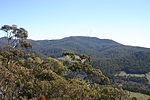
Mount Canobolas from the Pinnacle -

Transmission towers atop Mount Canobolas


See also
References
- ^ a b "3218.0 - Regional Population Growth, Australia, 2009-10: Population Estimates by Statistical District, 2001 to 2010". Australian Bureau of Statistics. 31 March 2011. Retrieved 23 August 2011. Estimated resident population (ERP) at 30 June 2010.
- ^ "Climate statistics for Orange Post Office". Australian Bureau of Meteorology. Australian Government. Retrieved 21 February 2009.
- ^ "Great Circle Distance between ORANGE and SYDNEY". Geosciences Australia website. Commonwealth of Australia. Retrieved 28 August 2011.
- ^ "1960: Let the race begin". Australian Touring Car Championship, 25 Fabulous Years. Gordon, NSW: R&T Publishing. 1986. pp. 14–26. ISBN 0-9590378-2-9.
{{cite book}}:|access-date=requires|url=(help); Unknown parameter|coauthors=ignored (|author=suggested) (help) - ^ "PLACE NAMES". The Australian Women's Weekly (1932–1982). 1932–1982: National Library of Australia. 13 May 1964. p. 61. Retrieved 23 February 2011.
{{cite news}}: CS1 maint: location (link) - ^ "Suburb Search: Orange City Council". Local Council Boundaries. Division of Local Government. Retrieved 13 May 2011.
- ^ "Event information". Australian National Field Days. Retrieved 13 May 2011.
- ^ "Extract: Lucknow". Geographical Names Board of New South Wales. Retrieved 12 May 2011.
- ^ "Climate statistics for Orange Airport". Bureau of Meteorology. Commonwealth of Australia. 2 June 2011. Retrieved 7 June 2011.
- ^ http://www.centralwesterndaily.com.au/news/local/news/general/stink-over-effluent/1557992.aspx
- ^ http://www.winesoforange.com.au/
- ^ "Orange Blues Club". Retrieved 8 November 2011.
- ^ "Black Stump Blues Festival". Retrieved 8 November 2011.
- ^ "Orange Jazz Club". Retrieved 8 November 2011.
- ^ "Orange railway station". www.nswrail.net. Retrieved 7 April 2008.
- ^ "Orange East Fork Platform". www.nswrail.net. Retrieved 7 April 2008.
- ^ [1]
- ^ "Jason Belmonte: player profile". Professional Bowlers Association. 2011. Retrieved 7 January 2012.
- ^ Billy Bevan at IMDb
- ^ Byrnes, Holly (8 August 2011). "Kate Bracks of Orange in NSW wins MasterChef in 2011". The Daily Telegraph. Australia. Retrieved 8 August 2011.
- ^ Hume, Anika (16 November 2011). "The Wiggles come to Mudgee". Mudgee Guardian. Retrieved 15 January 2012.
- ^ "Former deputy premier Cutler dead". The Sydney Morning Herald. 24 September 2006. Retrieved 12 February 2009.
- ^ Rutledge, Martha. "Dalton, James (1834–1919)". Australian Dictionary of Biography. National Centre of Biography, Australian National University. Retrieved 15 January 2012.
- ^ Mark Furze at IMDb
- ^ Wainwright, Robert (1 December 2007). "Don't let this fresh face fool you". The Sydney Morning Herald. Retrieved 15 January 2012.
- ^ Swanton, Bruce. "Hanson, Frederick John (1914–1980)". Australian Dictionary of Biography. National Centre of Biography, Australian National University. Retrieved 15 January 2012.
- ^ Hill, A. J. "Howse, Sir Neville Reginald (1863–1930)". Australian Dictionary of Biography. National Centre of Biography, Australian National University. Retrieved 15 January 2012.
- ^ "Australia: Players & Officials: David Lyons". ESPN Scrum. 2011. Retrieved 16 January 2012.
- ^ "James Maloney profile". Television New Zealand. 7 August 2009. Retrieved 6 October 2011.
- ^ Ritchie, Dean (6 August 2009). "Eels send Daniel Mortimer back to family vineyard in Orange to re-charge". The Daily Telegraph. Australia. Retrieved 16 January 2012.
- ^ "About us". Mortimers of Orange. 2010. Retrieved 16 January 2012.
- ^ "Lucas John Kendall Parsons - Golf Champion". Orange City Council. Archived from the original on 19 July 2008. Retrieved 24 July 2009.
- ^ Semmler, Clement. "Paterson, Andrew Barton (Banjo) (1864–1941)". Australian Dictionary of Biography. National Centre of Biography, Australian National University. Retrieved 15 January 2012.
- ^ Haskell, Dennis. "Slessor, Kenneth Adolf (1901–1971)". Australian Dictionary of Biography. National Centre of Biography, Australian National University. Retrieved 15 January 2012.
- ^ Stephens, Tony (19 July 2004). "Would-be Queen Susan dies uncrowned". The Sydney Morning Herald. Retrieved 15 January 2012.
External links
- Orange City Council
- [2] from the Australian Bureau of Statistics
- New South Wales Department of Primary Industries
- Collection of 18 images of Orange in 1996 – National Library of Australia
- FM107.5 The Local Community Radio Station