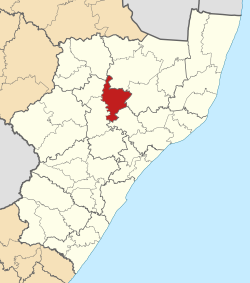
Nquthu Local Municipality
Nquthu | |
|---|---|
 Location in KwaZulu-Natal | |
| Country | South Africa |
| Province | KwaZulu-Natal |
| District | uMzinyathi |
| Seat | Nquthu |
| Wards | 17 |
| Government | |
| • Type | Municipal council |
| • Mayor | Mr IL Shabalala |
| Area | |
• Total | 1,962 km2 (758 sq mi) |
| Population (2011)[2] | |
• Total | 165,307 |
| • Density | 84/km2 (220/sq mi) |
| Racial makeup (2011) | |
| • Black African | 99.7% |
| • Coloured | 0.1% |
| • Indian/Asian | 0.1% |
| • White | 0.1% |
| First languages (2011) | |
| • Zulu | 90.1% |
| • Sotho | 6.6% |
| • Other | 3.3% |
| Time zone | UTC+2 (SAST) |
| Municipal code | KZN242 |
Nquthu Municipality (Zulu: UMasipala wase Nquthu) is a local municipality within the Umzinyathi District Municipality, in the KwaZulu-Natal province of South Africa. Nquthu is an isiZulu word meaning "the back of the head".[4]
Isandlwana is the site of a historic Anglo-Zulu War battle that took place on 22 January 1879, and is a well known tourist destination worldwide.[5]
Main places
[edit]The 2001 census divided the municipality into the following main places:[6]
| Place | Code | Area (km2) | Population |
|---|---|---|---|
| Buthanani | 52001 | 88.20 | 9,050 |
| Emandleni | 52002 | 250.76 | 8,877 |
| Godide | 52003 | 46.00 | 2,191 |
| Hlatshwayo | 52004 | 49.50 | 5,135 |
| Khiphinkunzi | 52005 | 168.71 | 26,233 |
| Mangidini | 52006 | 39.48 | 2,963 |
| Mbokodwebomvu | 52007 | 81.09 | 6,083 |
| Molefe | 52008 | 547.55 | 61,029 |
| Nondweni | 52009 | 7.61 | 7,173 |
| Nquthu | 52010 | 40.69 | 8,113 |
| Vulindlela | 52011 | 94.34 | 4,335 |
| Zondi | 52012 | 40.03 | 3,834 |
Politics
[edit]The municipal council consists of thirty-seven members elected by mixed-member proportional representation. Seventeen councillors are elected by first-past-the-post voting in seventeen wards, while the remaining sixteen are chosen from party lists so that the total number of party representatives is proportional to the number of votes received.
In the election of 1 November 2021 the Inkatha Freedom Party (IFP) won a majority of nineteen seats.
The following table shows the results of the 2021 election.[7]
| Party | Ward | List | Total seats | |||||
|---|---|---|---|---|---|---|---|---|
| Votes | % | Seats | Votes | % | Seats | |||
| Inkatha Freedom Party | 20,789 | 49.25 | 14 | 21,665 | 51.03 | 5 | 19 | |
| African National Congress | 15,222 | 36.06 | 5 | 15,385 | 36.23 | 9 | 14 | |
| Abantu Batho Congress | 3,030 | 7.18 | 0 | 2,955 | 6.96 | 3 | 3 | |
| Economic Freedom Fighters | 741 | 1.76 | 0 | 779 | 1.83 | 1 | 1 | |
| Independent candidates | 704 | 1.67 | 0 | 0 | ||||
| Democratic Alliance | 355 | 0.84 | 0 | 342 | 0.81 | 0 | 0 | |
| National Freedom Party | 298 | 0.71 | 0 | 312 | 0.73 | 0 | 0 | |
| Future Generation Congress | 223 | 0.53 | 0 | 190 | 0.45 | 0 | 0 | |
| African Christian Democratic Party | 169 | 0.40 | 0 | 195 | 0.46 | 0 | 0 | |
| National Peoples Ambassadors | 126 | 0.30 | 0 | 140 | 0.33 | 0 | 0 | |
| African Transformation Movement | 135 | 0.32 | 0 | 103 | 0.24 | 0 | 0 | |
| African People's Movement | 115 | 0.27 | 0 | 108 | 0.25 | 0 | 0 | |
| People's Freedom Party | 112 | 0.27 | 0 | 87 | 0.20 | 0 | 0 | |
| Forum for Service Delivery | 77 | 0.18 | 0 | 79 | 0.19 | 0 | 0 | |
| African Mantungwa Community | 73 | 0.17 | 0 | 68 | 0.16 | 0 | 0 | |
| United Christian Democratic Party | 42 | 0.10 | 0 | 51 | 0.12 | 0 | 0 | |
| Total | 42,211 | 100.00 | 19 | 42,459 | 100.00 | 18 | 37 | |
| Valid votes | 42,211 | 98.61 | 42,459 | 98.52 | ||||
| Invalid/blank votes | 593 | 1.39 | 637 | 1.48 | ||||
| Total votes | 42,804 | 100.00 | 43,096 | 100.00 | ||||
| Registered voters/turnout | 80,324 | 53.29 | 80,324 | 53.65 | ||||
References
[edit]- ^ "Contact list: Executive Mayors". Government Communication & Information System. Archived from the original on 14 July 2010. Retrieved 22 February 2012.
- ^ a b "Statistics by place". Statistics South Africa. Retrieved 27 September 2015.
- ^ "Statistics by place". Statistics South Africa. Retrieved 27 September 2015.
- ^ South African Languages - Place names
- ^ KwaZulu-Natal Top Business - Nquthu Municipality
- ^ Lookup Tables - Statistics South Africa
- ^ "Election Result Table for LGE2021 — Nquthu". wikitable.frith.dev. Retrieved 2021-11-28.


