Nanpi County
Appearance
(Redirected from Nanpi)
Nanpi County
南皮县 | |
|---|---|
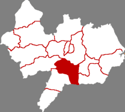
 Nanpi in Cangzhou | |
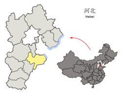
 Cangzhou in Hebei | |
| Coordinates: 38°02′20″N 116°42′29″E / 38.039°N 116.708°E | |
| Country | People's Republic of China |
| Province | Hebei |
| Prefecture-level city | Cangzhou |
| Area | |
• Total | 836 km2 (323 sq mi) |
| Elevation | 11 m (35 ft) |
| Population (2020) | |
• Total | 347,473 |
| • Density | 420/km2 (1,100/sq mi) |
| Time zone | UTC+8 (China Standard) |
| Postal code | 061500 |
| Area code | 0317 |
Nanpi (Chinese: 南皮; pinyin: Nánpí) is a county in the east of Hebei province, China, bordering Shandong province to the south. It is under the administration of the prefecture-level city of Cangzhou. As of 2020[update], it has a population of around 350,000 residing in an area of 836 km2 (323 sq mi).
Administrative divisions
[edit]There are 6 towns and 3 townships under the county's administration.[1]
Towns:
- Nanpi (南皮镇), Fengjiakou (冯家口镇), Zhaizi (寨子镇), Baoguantun (鲍官屯镇), Wangsi (王寺镇), Wumaying (乌马营镇)
Townships:
- Dalangdian Township (大浪淀乡), Liubali Township (刘八里乡), Luguan Township (潞灌乡)
History
[edit]Nanpi in the history has been pretty famous due to its mention in the epic novel "Heroes in the marsh" 水滸傳 in Ming Dynasty. At that time the town was named Da Ming Fu and featured in the novel Water Margin 大名府.[2]
It is also the home town of an important figure in late Qing Dynasty: Zhang ZhiDong 張之洞, who has been a governor to Hunan, Hubei, etc.
Climate
[edit]| Climate data for Nanpi, elevation 11 m (36 ft), (1991–2020 normals, extremes 1981–2010) | |||||||||||||
|---|---|---|---|---|---|---|---|---|---|---|---|---|---|
| Month | Jan | Feb | Mar | Apr | May | Jun | Jul | Aug | Sep | Oct | Nov | Dec | Year |
| Record high °C (°F) | 16.2 (61.2) |
22.3 (72.1) |
30.5 (86.9) |
32.5 (90.5) |
40.0 (104.0) |
40.9 (105.6) |
41.7 (107.1) |
37.4 (99.3) |
35.7 (96.3) |
31.8 (89.2) |
24.9 (76.8) |
17.7 (63.9) |
41.7 (107.1) |
| Mean daily maximum °C (°F) | 3.1 (37.6) |
7.2 (45.0) |
14.0 (57.2) |
21.3 (70.3) |
27.3 (81.1) |
31.9 (89.4) |
32.2 (90.0) |
30.6 (87.1) |
27.1 (80.8) |
20.7 (69.3) |
11.7 (53.1) |
4.6 (40.3) |
19.3 (66.8) |
| Daily mean °C (°F) | −2.8 (27.0) |
0.9 (33.6) |
7.4 (45.3) |
14.6 (58.3) |
20.8 (69.4) |
25.7 (78.3) |
27.3 (81.1) |
25.8 (78.4) |
21.1 (70.0) |
14.2 (57.6) |
5.8 (42.4) |
−0.9 (30.4) |
13.3 (56.0) |
| Mean daily minimum °C (°F) | −7.1 (19.2) |
−3.8 (25.2) |
2.0 (35.6) |
8.7 (47.7) |
14.7 (58.5) |
19.9 (67.8) |
22.9 (73.2) |
21.7 (71.1) |
16.2 (61.2) |
9.1 (48.4) |
1.4 (34.5) |
−4.9 (23.2) |
8.4 (47.1) |
| Record low °C (°F) | −18.5 (−1.3) |
−17.5 (0.5) |
−10.4 (13.3) |
−3.2 (26.2) |
4.4 (39.9) |
9.0 (48.2) |
16.2 (61.2) |
13.4 (56.1) |
3.5 (38.3) |
−3.6 (25.5) |
−14.7 (5.5) |
−20.5 (−4.9) |
−20.5 (−4.9) |
| Average precipitation mm (inches) | 2.7 (0.11) |
8.5 (0.33) |
8.9 (0.35) |
24.3 (0.96) |
33.6 (1.32) |
72.1 (2.84) |
186.8 (7.35) |
138.3 (5.44) |
34.8 (1.37) |
33.0 (1.30) |
15.0 (0.59) |
3.6 (0.14) |
561.6 (22.1) |
| Average precipitation days (≥ 0.1 mm) | 1.7 | 2.7 | 2.6 | 5.1 | 5.9 | 8.6 | 10.7 | 9.5 | 5.6 | 5.0 | 4.0 | 2.4 | 63.8 |
| Average snowy days | 2.4 | 2.7 | 1.0 | 0.2 | 0 | 0 | 0 | 0 | 0 | 0 | 1.1 | 1.7 | 9.1 |
| Average relative humidity (%) | 58 | 55 | 51 | 55 | 58 | 60 | 75 | 79 | 72 | 66 | 66 | 62 | 63 |
| Mean monthly sunshine hours | 183.2 | 185.7 | 241.3 | 250.9 | 281.1 | 246.0 | 215.8 | 212.7 | 214.2 | 207.6 | 171.1 | 169.6 | 2,579.2 |
| Percentage possible sunshine | 60 | 61 | 65 | 63 | 64 | 56 | 48 | 51 | 58 | 61 | 57 | 58 | 59 |
| Source: China Meteorological Administration[3][4] | |||||||||||||
References
[edit]- ^ 2011年统计用区划代码和城乡划分代码:南皮县 (in Chinese). National Bureau of Statistics of the People's Republic of China. Archived from the original on November 29, 2012. Retrieved 2012-07-18.
- ^ "Zhang Zhidong | Chinese Official & Reformist | Britannica".
- ^ 中国气象数据网 – WeatherBk Data (in Simplified Chinese). China Meteorological Administration. Retrieved 26 August 2023.
- ^ "Experience Template" 中国气象数据网 (in Simplified Chinese). China Meteorological Administration. Retrieved 26 August 2023.
External links
[edit]
