Nakhon Sawan province
Nakhon Sawan
นครสวรรค์ | |
|---|---|
( from top left) 2018 Nakhon Sawan or Pak Nam Pho Chinese New Year Festival, Rapids in Mae Wong National Park, View of Nakhon Sawan city or Pak Nam Pho, Chumamani Chedi, Bueng Boraphet | |
| Nickname(s): Pak Nam Pho (Thai: ปากน้ำโพ) Khon Wan (Thai: คอนหวัน) Mueang Si Khwae (Thai: เมืองสี่แคว) (city of four tributaries) | |
| Motto(s): เมืองสี่แคว แห่มังกร พักผ่อนบึงบอระเพ็ด ปลารสเด็ดปากน้ำโพ ("City of four tributaries. Dragon festival. Rest at Bueng Boraphet. Delicious fish of Pak Nam Pho.") | |
 Map of Thailand highlighting Nakhon Sawan province | |
| Country | Thailand |
| Capital | Nakhon Sawan city |
| Government | |
| • Governor | Chayan Sirimas (since October 2021) |
| Area | |
• Total | 9,526 km2 (3,678 sq mi) |
| • Rank | Ranked 20th |
| Population (2019)[2] | |
• Total | 1,059,887 |
| • Rank | Ranked 21st |
| • Density | 111/km2 (290/sq mi) |
| • Rank | Ranked 46th |
| Human Achievement Index | |
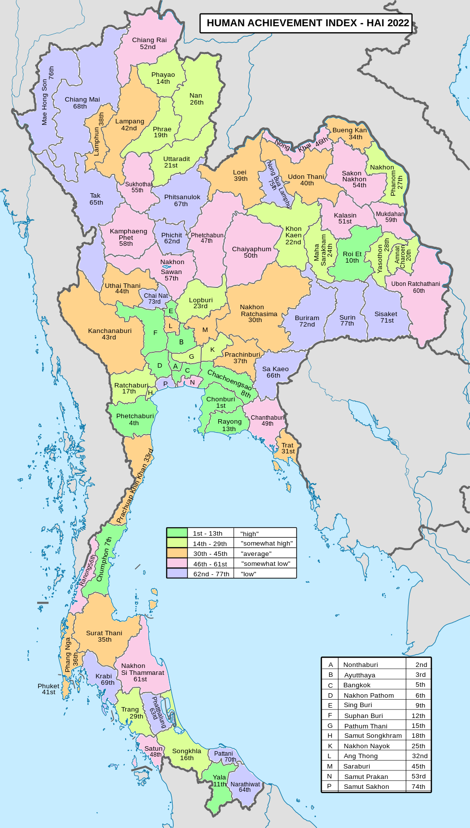
| • HAI (2022) | 0.6288 "somewhat low" Ranked 57th |
| GDP | |
| • Total | baht 107 billion (US$3.7 billion) (2019) |
| Time zone | UTC+7 (ICT) |
| Postal code | 60xxx |
| Calling code | 056 |
| ISO 3166 code | TH-60 |
| Website | www |
Nakhon Sawan (Thai: นครสวรรค์, pronounced [ná(ʔ).kʰɔ̄ːn sā.wǎn], lit. 'Heavenly City') is one of Thailand's seventy-six provinces (changwat). It lies in lower northern Thailand, neighbouring the provinces of Kamphaeng Phet, Phichit, Phetchabun, Lopburi, Sing Buri, Chai Nat, Uthai Thani, and Tak (clockwise from north).
Toponymy
[edit]The word nakhon originates from the Sanskrit word nagara meaning 'city', and the word sawan from Sanskrit svarga meaning 'heaven'. Hence the name of the province literally means 'city of heaven' or 'heavenly city'.
History
[edit]Nakhon Sawan province was a city since Dvaravati era. While part of the Sukhothai Kingdom, it was called Mueang Phra Bang, the southern frontier city of Sukhothai. Later within the Ayutthaya kingdom it was an important trade center because of its location at the two major rivers from the north. It also was the common meeting point of Burmese troops before moving to attack Ayutthaya. In the reign of King Taksin the Great, Phra Bang became a Siamese military base to prevent further Burmese attacks.
When King Mongkut signed the Bowring Treaty with Britain the glorious time of Nakhon Sawan began, as it became the main rice and teak trading centre. However the opening of the northern railway in 1922, the economic crisis before 1932 revolution, and finally the opening of Dejativongse bridge and Phahonyothin highway in 1950 each decreased the importance of water transportation and thus made Nakhon Sawan less important.
When in 1895 King Chulalongkorn established the monthon as part of the Thesaphiban administrative reform, Nakhon Sawan became capital city of Monthon Nakhon Sawan.
The 4th Infantry Regiment of the 3rd Area Army is based in Nakhon Sawan. It is responsible for defending the northwestern border with Burma, from Mae Hong Son in the north to Kanchanaburi in the south.[5]
Geography
[edit]The Ping and Nan rivers merge near the city of Nakhon Sawan to form the Chao Phraya River. Mae Wong National Park, on the border with Khamphaeng Phet province, was created in 1987 to preserve the woodlands of Mae Wong-Mae Poen. The forested area covers 927 km2 (358 sq mi) or 9.7 percent of provincial area.[1]
Bueng Boraphet is the largest freshwater wetland in Thailand, in total covering 212 km2. The swamp is directly east of the town Nakhon Sawan and extends into the districts of Tha Tako and Chum Saeng. During the winter months many waterfowl migrate there. Parts of the swamp, covering 106 km2, are protected as a non-hunting area.[6]
There is one national park, along with two other national parks, make up region 12 (Nakhon Sawan) of Thailand's protected areas.
National park
[edit]- Mae Wong National Park, 894 km2 (345 sq mi)[7]: 54
Symbols
[edit]The provincial seal shows a Wiman, a mythological heavenly castle. This relates to the name of the province which translates to 'Heavenly City'.
The provincial tree as well as the flower is Lagerstroemia loudonii (Loudon's crape myrtle). Iridescent shark (Pangasianodon hypophthalmus) is the provincial fish.
Administrative divisions
[edit]Provincial government
[edit]The province is divided in 15 districts (amphoe). These are further divided into 130 subdistricts (tambon) and 1,328 villages (muban).

|
|
Local government
[edit]As of 26 November 2019 there are:[8] one Nakhon Sawan Provincial Administration Organisation (ongkan borihan suan changwat) and 21 municipal (thesaban) areas in the province. Nakhon Sawan has city (thesaban nakhon) status and Takhli and Chum Saeng have town (thesaban mueang) status. Further 18 subdistrict municipalities (thesaban tambon). The non-municipal areas are administered by 121 Subdistrict Administrative Organisations - SAO (ongkan borihan suan tambon).[2]
Transport
[edit]Roads
[edit]Nakhon Sawan lies on Route 1 (Phahonyothin Road), which runs from Bangkok through Ayutthaya and Saraburi before passing through Nakhon Sawan, then continues through Kamphaeng Phet, Lampang, and Chiang Rai until it reaches the border with Burma at Mae Sai. Route 117 leads north to Phitsanulok, and Route 225 leads east to Chaiyaphum.

Rail
[edit]Nakhon Sawan has a station, Nakhon Sawan Railway Station, on the Northern Line of the State Railway of Thailand. The station is on the east side of the river, opposite the main city on the west side.
Air
[edit]Nakhon Sawan is served by Nakhon Sawan Airport.[9]
Health
[edit]Sawanpracharak Hospital is the main hospital of the province.
Human achievement index 2022
[edit]Since 2003, United Nations Development Programme (UNDP) in Thailand has tracked progress on human development at sub-national level using the Human achievement index (HAI), a composite index covering all the eight key areas of human development. National Economic and Social Development Board (NESDB) has taken over this task since 2017.[3]
| Rank | Classification |
| 1–13 | "High" |
| 14–29 | "Somewhat high" |
| 30–45 | "Average" |
| 46–61 | "Somewhat low" |
| 62–77 | "Low" |
| Map with provinces and HAI 2022 rankings |

|
Festivals
[edit]- Pak Nam Pho Chinese New Year Festival: Nakhon Sawan is considered a province with a large population of Thai Chinese descent. The Chinese New Year festival here is therefore a great celebration and held continuously for over 100 years along with attracts tourists from all over, both domestically and internationally.[10]
- Tak Bat Theworohana Festival: The tradition of offering food to monks during the Buddhist Lent Festival (around late October to early November before Loi Krathong) at Wat Khao Kob, a temple on the highest mountaintop of Nakhon Sawan city.
Attractions
[edit]References
[edit]- ^ a b "ตารางที่ 2 พี้นที่ป่าไม้ แยกรายจังหวัด พ.ศ.2562" [Table 2 Forest area Separate province year 2019]. Royal Forest Department (in Thai). 2019. Retrieved 6 April 2021, information, Forest statistics Year 2019, Thailand boundary from Department of Provincial Administration in 2013
{{cite web}}: CS1 maint: postscript (link)[not specific enough to verify] - ^ a b รายงานสถิติจำนวนประชากรและบ้านประจำปี พ.ส.2562 [Statistics, population and house statistics for the year 2019]. Registration Office Department of the Interior, Ministry of the Interior. stat.bora.dopa.go.th (in Thai). 31 December 2019. Archived from the original on 14 June 2019. Retrieved 26 February 2020.
- ^ a b "ข้อมูลสถิติดัชนีความก้าวหน้าของคน ปี 2565 (PDF)" [Human Achievement Index Databook year 2022 (PDF)]. Office of the National Economic and Social Development Council (NESDC) (in Thai). Retrieved 12 March 2024, page 36
{{cite web}}: CS1 maint: postscript (link) - ^ "Gross Regional and Provincial Product, 2019 Edition". <>. Office of the National Economic and Social Development Council (NESDC). July 2019. ISSN 1686-0799. Retrieved 22 January 2020.
- ^ กรมทหารราบที่ 4, ภารกิจ Archived 2007-09-30 at the Wayback Machine
- ^ "Bung Boraphet Marine Sanctuary - Nakhon Sawan Tourist Attraction". Archived from the original on 2011-10-11. Retrieved 2012-01-30.
- ^ "ข้อมูลพื้นที่อุทยานแห่งชาติ ที่ประกาศในราชกิจจานุบกษา 133 แห่ง" [National Park Area Information published in the 133 Government Gazettes]. Department of National Parks, Wildlife and Plant Conservation (in Thai). December 2020. Retrieved 1 November 2022.
- ^ "Number of local government organizations by province". dla.go.th. Department of Local Administration (DLA). 26 November 2019. Retrieved 10 December 2019.
22 Nakhon Sawan: 1 PAO, 1 City mun., 2 Town mun., 18 Subdistrict mun., 121 SAO
- ^ "Nakhon Sawan Airport". OurAirports. Retrieved 4 February 2013.
- ^ Zoom (2020-01-19). "ซูมซอกแซก : ตรุษจีน "นครสวรรค์" 104 ปีแห่งความศรัทธา" [Zoom zokzaek : Chinese New Year "Nakhon Sawan" 104 years of faith]. Thai Rath (in Thai). Retrieved 2020-03-03.


