Musée des 24 Heures du Mans
Musée des 24 Heures du Mans | |
 | |
 | |
| Established | 1961 |
|---|---|
| Location | Circuit des 24 Heures du Mans, 72009, Le Mans, France |
| Coordinates | 47°57′25″N 0°12′31″E / 47.95694°N 0.20861°E |
| Collection size | 150 sports cars |
| Visitors | 110,000 |
| Website | www.lemans-musee24h.com |
The Museum of the 24 Hours of Le Mans (French: Musee des 24 Heures du Mans) is a motorsport museum located at the Circuit de la Sarthe in Le Mans, France. It was founded in 1961 as the Automobile Museum de la Sarthe. In 1991, it was taken over by the organizers of the 24 hours road race and moved to a purpose built museum complex under the direction of Francis Piquera, the Executive Manager. [1]
In 2009, the museum was extensively renovated. Its permanent exhibition includes over 100 historic cars, many collectibles, dozens of films and archive photographs. The museum tour is organized around six major sequences that showcase the important figures of the 24 Hour race and origins of the Le Mans automotive industry, tracing the evolution of the car in the twentieth century.[2]
With their legendary models of the greatest endurance race in the world, 350m² of temporary exhibitions complete the thematic exhibition.
A visit of the famous circuit of the 24 Hours of Le Mans race is possible.
Collection
[edit]Historic cars
[edit]-
La Mancelle 1878
-
De Dion Bouton & Trepardoux Dog Cart a Vapeur
-
Amedee Bollee Type D Runabout
-
1904 Renault Freres Tonneau Type U-D 4cyl 3770 cm3
Local cars
[edit]-
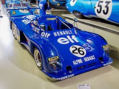
1975 Alpine Renault A441 Renault-Gordini V6 2ACT 1997 cm3
-
Rondeau-M382-Cosworth
-
Peugeot 905 Evo2
-
Pescarolo C60
Modern cars
[edit]-
2015 Nissan GT-R LM Nismo V6 3000 cm3
-
Audi R8 Safety Car 24 heures du Mans
-
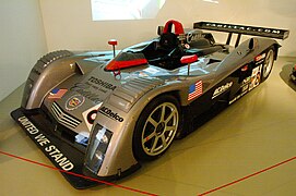
Cadilac Northstar LMP 900
-
1999 Chevrolet Corvette C5 V8 5666 cm3
See also
[edit]References
[edit]- ^ Schmidt, Bjoern; Andreas Birner; Bjoern Schmidt; Peter Singhof; Keith Bluemel; Helmut Schnug; Thierry Lesparretion; Kare M A Pietila; Edvar van Daalen; Mark Ketcham; Mike Sheehan; James Davies; Jarrett Rothmeier; Bill Wagenblatt (2010). "Musée Automobilede la Sarthe". Germany: H&M System Software GmbH. Retrieved 31 Oct 2011.
- ^ "Centre Culturel de la Sarthe; Musée; Musée des 24 Heures". France: Centre Culturel de la Sarthe. 2010. Retrieved 31 Oct 2011.
External links
[edit]47°57′25″N 0°12′31″E / 47.95694°N 0.20861°E


