Anmatjere, Northern Territory
| Anmatjere Northern Territory | |||||||||||||||
|---|---|---|---|---|---|---|---|---|---|---|---|---|---|---|---|
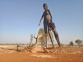
 Sculpture at the Aileron Roadhouse on the Stuart Highway | |||||||||||||||
| Coordinates | 21°44′47″S 133°19′08″E / 21.7463°S 133.319°E[1] | ||||||||||||||
| Population | 477 (2016 census)[2] [a] | ||||||||||||||
| • Density | 0.008758/km2 (0.022684/sq mi) | ||||||||||||||
| Established | 4 April 2007[1] | ||||||||||||||
| Postcode(s) | 0872[3] | ||||||||||||||
| Elevation | 566 m (1,857 ft)(weather station) [4] | ||||||||||||||
| Area | 54,462 km2 (21,027.9 sq mi)[5] | ||||||||||||||
| Time zone | ACST (UTC+9:30) | ||||||||||||||
| Location | 1,088 km (676 mi) S of Darwin City[3] | ||||||||||||||
| LGA(s) | |||||||||||||||
| Territory electorate(s) | Stuart[7] | ||||||||||||||
| Federal division(s) | Lingiari[8] | ||||||||||||||
| |||||||||||||||
| |||||||||||||||
| Footnotes | Adjoining localities[9][10][6] | ||||||||||||||
Anmatjere is a locality in the Northern Territory of Australia located about 1,088 kilometres (676 mi) south of the territory capital of Darwin.[1][3]
History
[edit]The locality was named after the former Anmatjere Community Government Council, whose seat was located in the town of Ti-Tree. Its boundaries and name were gazetted on 4 April 2007.[9][1]
Governance and demographics
[edit]Anmatjere is located within the federal division of Lingiari, the territory electoral division of Stuart and the local government areas of the Barkly Shire and the Central Desert Region.[8][7][10][6][1]
The 2016 Australian census reports that Anmatjere had 477 people living within its boundaries, of whom 47.3% were male, 52.7% were female and 87.9% identified as Aboriginal and/or Torres Strait Islander people.[2]
Sites and attractions
[edit]The following sites located within Anmatjere are listed on the Northern Territory Heritage Register:[11][12][13][14][15]
- Aileron Homestead No. 1
- Alcoota Fossil Beds
- Anna's Reservoir Conservation Reserve
- Old Mount Riddock Homestead – Gemtree
- Ryan Well Historical Reserve
The homestead of Woodgreen Station, also known as Atartinga, is situated within Anmatjere.[16]
Mount Skinner, a mountain,[17] is within Anmatjere. The Ediacaran-aged fossil known as Skinnera is named for its discovery at from three sites near Mount Skinner.[18] Mount Skinner Station, a station of around 2,860 km2 (1,100 sq mi) in extent, is located approximately 160–200 km (99–124 mi) north of Alice Springs on the Sandover Highway.[19] The property was established in 1952 by John "Jock" Nelson, a Labor MP who served in the Australian House of Representatives for 17 years. The Nelson and Barber families held the pastoral lease on the property until 2019, when a South Australian family acquired the station. At that time it had around 2,500 Poll Hereford cattle.[20]
As of 2020[update], anthropologists' work is continuing on both Woodgreen and Mount Skinner pastoral leases as the basis for any future native title claims, under the auspices of the Central Land Council.[21]
Two sculptures, Anmatjere Man and Anmatjere Woman and Child, are located at the Aileron roadhouse.[22][23]
Footnotes
[edit]- ^ For the 2016 census, the population of the State Suburb of Anmatjere (whose boundaries align with those of the locality of Anmatjere), does not include the population of the following communities which are fully surrounded by the locality – Engawala, Laramba, Ti-Tree, Willora, Willowra and Yuelamu
References
[edit]- ^ a b c d e f "Place Names Register Extract for Anmatjere". NT Place Names Register. Northern Territory Government. Retrieved 27 October 2019.
- ^ a b Australian Bureau of Statistics (27 June 2017). "Anmatjere (State Suburb)". 2016 Census QuickStats. Retrieved 27 October 2019.
- ^ a b c "Anmatjere Postcode". postcode-finders.com.au. Retrieved 27 October 2019.
- ^ a b c d "Monthly climate statistics: Summary statistics Territory Grape Farm (nearest weather station with recent published data)". Commonwealth of Australia, Bureau of Meteorology. Retrieved 27 October 2019.
- ^ "Anmatjere". Australias Guide Pty Ltd. Retrieved 19 January 2020.
- ^ a b c "Localities within Central Desert Shire (sic) (map)" (PDF). Northern Territory Government. 2 April 2007. Archived from the original (PDF) on 18 March 2019. Retrieved 27 October 2019.
- ^ a b "Division of Daly". Northern Territory Electoral Commission. Archived from the original on 20 March 2020. Retrieved 28 October 2019.
- ^ a b "Profile of the electoral division of Lingiari (NT)". Australian Electoral Commission. Retrieved 28 October 2019.
- ^ a b "Anmatjere". NT Atlas and Spatial Data Directory. Northern Territory Government. Retrieved 27 October 2019.
- ^ a b "Localities within Barkly Region (map)" (PDF). Northern Territory Government. 2 April 2007. Archived from the original (PDF) on 18 March 2019. Retrieved 27 October 2019.
- ^ "Aileron Homestead No 1". Heritage Register. Northern Territory. 16 November 2005. Retrieved 27 October 2019.
- ^ "Alcoota Fossil Beds". Heritage Register. Northern Territory. 8 February 1995. Retrieved 27 October 2019.
- ^ "Anna's Reservoir Conservation Reserve". Heritage Register. Northern Territory. 8 February 1995. Retrieved 27 October 2019.
- ^ "Old Mount Riddock Homestead - Gemtree". Heritage Register. Northern Territory. 8 April 2016. Retrieved 27 October 2019.
- ^ "Ryan Well Historical Reserve". Heritage Register. Northern Territory. 8 February 1995. Retrieved 27 October 2019.
- ^ "Place Names Register". NT Place Names Register. Northern Territory Government. Department of Infrastructure, Planning and Logistics. Retrieved 30 October 2022.
- ^ "Mount Skinner, Northern Territory". Google Maps. Retrieved 30 October 2022.
- ^ Wade, M (1969). "Medusae from uppermost Precambrian or Cambrian sandstones, central Australia" (PDF). Palaeontology. 12: 351–365.
- ^ "Land Units Mt Skinner Station". Dataset. 23 June 2021. Retrieved 30 October 2022. Metadata
- ^ Price, Jack (31 July 2019). "Red Centre cattle property Mt Skinner sold to South Australian family for almost $10 million". ABC News. Retrieved 30 October 2022.
- ^ "Native title claimants paint Nyterrm Dreaming" (PDF). Land Rights News (Central Australia). 10 (1): 21. March 2020. Retrieved 30 October 2022.
- ^ "Sculpture of Anmatjere man unveiled in Aileron". ABC Local Radio. The World Today. Australian Broadcasting Corporation. Retrieved 21 April 2021.
- ^ "'Anmatjere Woman and Child' Airelon Sculpture NT". The Stone Family in Australia. Retrieved 21 April 2021.

