Mongping State
Appearance
(Redirected from Mongping)
| Mongping State Möngping | |||||||
|---|---|---|---|---|---|---|---|
| State of the Shan States | |||||||
| 17th century–1842 | |||||||
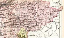
 Möngping State in an Imperial Gazetteer of India map | |||||||
| Capital | Mong Ping (Lawksawk) | ||||||
| History | |||||||
• Founded as vassal state of Lawksawk | 17th century | ||||||
• Annexed by Lawksawk | 1842 | ||||||
| |||||||
Mongping or Möngping (Burmese: Maingpyin) was the smallest state of the Shan States in what is today Burma.
History
[edit]Little is known about the history of this state except that in 1842 it was merged with Lawksawk.[1] It was located at the southeastern end of that state, separated from it by the Nam Et River.
Rulers
[edit]- 1835 - 1842 Hkam Hlaing
- 1842 - .... Hkam Kaw
References
[edit]- ^ Ben Cahoon (2000). "World Statesmen.org: Shan and Karenni States of Burma". Retrieved 21 December 2010.
