Minahasa Peninsula
Appearance
(Redirected from Minahassa Peninsula)
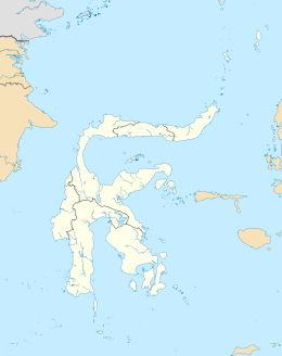
 The Minahasa Peninsula is the long peninsula in northern Sulawesi, north of the Gulf of Tomini. | |
| Geography | |
|---|---|
| Location | Southeast Asia |
| Coordinates | 0°50′00″N 121°0′00″E / 0.83333°N 121.00000°E |
| Adjacent to | Celebes Sea Molucca Sea Gulf of Tomini Makassar Strait |
| Administration | |
| Province | |
| Largest settlement | Manado |
The Minahasa Peninsula, also spelled Minahassa, is one of the four principal peninsulas on the Indonesian island of Sulawesi. It stretches north from the central part of the island, before turning to the east and forming the northern boundary of the Gulf of Tomini and the southern boundary of the Celebes Sea.
The peninsula is divided into North Sulawesi and Gorontalo provinces, as well as part of Central Sulawesi. Its largest cities are Manado and Gorontalo, while Palu is located at its base.
The Minahasan people live in this area.[1][2] The Minahasan languages, a branch of the Philippine languages, are spoken on the peninsula.
References
[edit]- ^ Media, Kompas Cyber (2022-09-03). "Mengenal Suku Minahasa, dari Asal Usul hingga Tradisi Halaman all". KOMPAS.com (in Indonesian). Retrieved 2024-02-01.
- ^ "Sejarah Minahasa (Bagian.Pertama)" (in Indonesian). Retrieved 2024-02-01.

