Pino Suárez metro station
Pino Suárez is a station on Line 1 and Line 2 of the Mexico City Metro system.[3][4][5] It is located in the Cuauhtémoc borough of Mexico City, on the southern part of the city center.[3] From July 2022 to October 2023, the Line 1 station was closed due to modernization works on the tunnel and the line's technical equipment.[6][7]
Name and pictogram
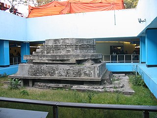
[edit]The station is named after José María Pino Suárez, Vice President of Mexico during the term of Francisco I. Madero (1911–1913).[3] However, the station logo depicts a pyramid dedicated to Ehecatl, the Aztec god of wind.[3][4][5] This pyramid was discovered in the early construction of the station and it can be seen on display along the main transfer corridor.[3]
General information
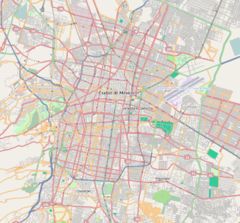
[edit]The station is located at the intersection of José María Pino Suárez and José María Izazaga avenues in downtown Mexico City, a few blocks from the Zócalo.
The Ehecatl pyramid was found during the construction of the station in 1967. While excavating was unearthed a round-shaped altar and was decided to let the pyramid remains and allow the National Institute of Archeology and History (INAH) to preserve and maintain it.[8]
This pyramid is the smallest archaeological zone in Mexico and is thought to have been part of a larger ceremonial center. The Ehecatl pyramid has 4 structural construction stages and it counts on a circular base that functioned as a pedestal for the deity placed at the top. Inside the pyramid have been found a few offerings.
Pino Suárez was opened on 5 September 1969.[9] The station is an important link to the centre of the city. It was the first transfer station of the network and it connects the two busiest lines. Pino Suárez has many corridors, the most notable among them being the Pasaje Zócalo–Pino Suárez that connects with Metro Zócalo at the north side, filled with bookstores and a mini-cinema; other corridors have cultural displays and temporary exhibitions. The station also has an information desk.[3]
Ridership
[edit]| Annual passenger ridership (Line 1) | |||||
|---|---|---|---|---|---|
| Year | Ridership | Average daily | Rank | % change | Ref. |
| 2023 | 1,606,411 | 4,401 | 167/195 | −57.73% | [2] |
| 2022 | 3,800,443 | 10,412 | 115/195 | −57.06% | [2] |
| 2021 | 8,849,949 | 24,246 | 18/195 | +10.21% | [10] |
| 2020 | 8,030,147 | 21,940 | 22/195 | −29.90% | [11] |
| 2019 | 11,456,022 | 31,386 | 37/195 | +2.94% | [12] |
| 2018 | 11,129,108 | 30,490 | 40/195 | −9.21% | [13] |
| 2017 | 12,258,193 | 33,584 | 30/195 | −1.51% | [14] |
| 2016 | 12,445,853 | 34,005 | 31/195 | +0.74% | [15] |
| 2015 | 12,354,196 | 33,847 | 32/195 | +0.63% | [16] |
| 2014 | 12,276,607 | 33,634 | 32/195 | −2.61% | [17] |
| Annual passenger ridership (Line 2) | |||||
|---|---|---|---|---|---|
| Year | Ridership | Average daily | Rank | % change | Ref. |
| 2023 | 12,440,452 | 33,083 | 15/195 | +49.85% | [2] |
| 2022 | 8,301,870 | 22,744 | 30/195 | +146.58% | [2] |
| 2021 | 3,366,820 | 9,224 | 93/195 | −41.64% | [10] |
| 2020 | 5,768,921 | 15,762 | 46/195 | −39.53% | [11] |
| 2019 | 9,540,733 | 26,138 | 54/195 | +4.51% | [12] |
| 2018 | 9,128,760 | 25,010 | 56/195 | −0.30% | [13] |
| 2017 | 9,155,813 | 25,084 | 52/195 | −4.60% | [14] |
| 2016 | 9,597,356 | 26,294 | 52/195 | +2.19% | [15] |
| 2015 | 9,391,308 | 25,729 | 53/195 | −1.97% | [16] |
| 2014 | 9,579,924 | 26,246 | 55/195 | −8.43% | [17] |
Exits
[edit]Line 1
[edit]- North: Av. José María Izazaga and Av. José María Pino Suárez, Col. Centro
- West: Av. José María Izazaga and Av. José María Pino Suárez, Col. Centro
Line 2
[edit]- South: San Lucas street and Av. Fray Servando Teresa de Mier, Col. Centro
- North: Av. José María Izazaga and Calzada San Antonio Abad, Col. Centro
Gallery
[edit]-
Entry sign for Metro Pino Suárez
-
One entrance to Metro Pino Suarez
-
Altar dedicated to the god Ehécatl, located in the middle of Metro Pino Suárez. This altar was unearthed during construction of the station in 1967 where it remains to this day surrounded by the passageway between Lines 1 and 2
-
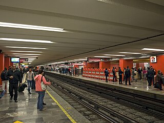
Line 1 platforms
See also
[edit]References
[edit]- ^ a b "Afluencia de estación por línea 2022" [Station traffic per line 2022] (in Spanish). Sistema Transporte Colectivo Metro. 2023. Archived from the original on 5 March 2023. Retrieved 5 March 2023.
- ^ a b c d e f "Afluencia de estación por línea 2023" [Station traffic per line 2023] (in Spanish). Sistema Transporte Colectivo Metro. 2024. Archived from the original on 27 January 2024. Retrieved 24 January 2024.
- ^ a b c d e f "Pino Suárez" (in Spanish). Archived from the original on 15 September 2011. Retrieved 14 August 2011.
- ^ a b Archambault, Richard. "Pino Suárez (Line 1) » Mexico City Metro System". Retrieved 14 August 2011.
- ^ a b Archambault, Richard. "Pino Suárez (Line 2) » Mexico City Metro System". Retrieved 14 August 2011.
- ^ "La L1 del Metro de CDMX cerrará de Pantitlán a Salto del Agua, desde el 11 de julio" [Metro Line 1 Will close station 11 July from Pantitlán to Salto del Agua]. La Lista (in Spanish). 27 June 2022. Retrieved 27 June 2022.
- ^ De la Rosa, Yared (29 October 2023). "Con 7 meses de retraso, reabren Línea 1 del Metro; sólo se podrá ingresar con tarjeta" [After a 7-month delay, Metro Line 1 reopens; access will be available with card only]. Forbes (in Spanish). Retrieved 29 October 2023.
- ^ "Pyramid of Pino Suarez". "Mexican Routes" [mexicanroutes.com]. 16 July 2018.
- ^ Monroy, Marco. Schwandl, Robert (ed.). "Opening Dates for Mexico City's Subway". Retrieved 14 August 2011.
- ^ a b "Afluencia de estación por línea 2021" [Station traffic per line 2021] (in Spanish). Sistema Transporte Colectivo Metro. 2022. Archived from the original on 7 March 2022. Retrieved 7 March 2022.
- ^ a b "Afluencia de estación por línea 2020" [Station traffic per line 2020] (in Spanish). Sistema Transporte Colectivo Metro. 2021. Archived from the original on 21 June 2021. Retrieved 21 June 2021.
- ^ a b "Afluencia de estación por línea 2019" [Station traffic per line 2019] (in Spanish). Sistema Transporte Colectivo Metro. 2020. Archived from the original on 8 April 2020. Retrieved 3 May 2020.
- ^ a b "Afluencia de estación por línea 2018" [Station traffic per line 2018] (in Spanish). Sistema Transporte Colectivo Metro. 2019. Archived from the original on 6 June 2019. Retrieved 7 April 2020.
- ^ a b "Afluencia de estación por línea 2017" [Station traffic per line 2017] (in Spanish). Sistema Transporte Colectivo Metro. 2019. Archived from the original on 3 May 2020. Retrieved 3 May 2020.
- ^ a b "Afluencia de estación por línea 2016" [Station traffic per line 2016] (in Spanish). Sistema Transporte Colectivo Metro. 2017. Archived from the original on 3 May 2020. Retrieved 3 May 2020.
- ^ a b "Afluencia de estación por línea 2015" [Station traffic per line 2015] (in Spanish). Sistema Transporte Colectivo Metro. 2016. Archived from the original on 3 May 2020. Retrieved 6 May 2020.
- ^ a b "Afluencia de estación por línea 2014" [Station traffic per line 2014] (in Spanish). Sistema Transporte Colectivo Metro. 2015. Archived from the original on 3 May 2020. Retrieved 6 May 2020.
External links
[edit] Media related to Estación Pino Suárez (Metro de México) at Wikimedia Commons
- "Pyramid of Ehécatl". Atlas Obscura.
- Pyramid of Pino Suarez, "Mexican Routes" [mexicanroutes.com]


