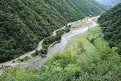
Machakhelistsqali
Appearance
(Redirected from Machakhlistskali)
This article includes a list of references, related reading, or external links, but its sources remain unclear because it lacks inline citations. (September 2013) |
This article relies largely or entirely on a single source. (June 2024) |
| Machakhelistsqali | |
|---|---|
 | |
 | |
| Native name | მაჭახელისწყალი (Georgian) |
| Location | |
| Country | Georgia, Turkey |
| Physical characteristics | |
| Source | |
| • location | Artvin Province, Turkey |
| Mouth | Çoruh |
• location | Adjara, Georgia |
• coordinates | 41°31′07″N 41°43′08″E / 41.5186°N 41.7189°E |
| Length | 37 km (23 mi) |
| Basin features | |
| Progression | Çoruh→ Black Sea |
The Machakhelistsqali or Machakhlitskal (Georgian: მაჭახელისწყალი, Mač’axelisc’q’ali; Turkish: Maçahel Suyu) is a river that flows from the Artvin Province in Turkey to Adjara autonomous republic of Georgia. It's a right tributary of the Çoruh (Chorokhi).
References
[edit]- Abashidze, Irakli (1983). Georgian Soviet Encyclopedia. Vol. 6, Tb. p. 515.
