Longreach Region
| Longreach Region Queensland | |||||||||||||||
|---|---|---|---|---|---|---|---|---|---|---|---|---|---|---|---|
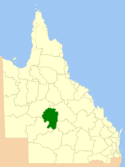
 Location within Queensland | |||||||||||||||
| Population | 3,647 (2021 census)[1] | ||||||||||||||
| • Density | 0.089784/km2 (0.23254/sq mi) | ||||||||||||||
| Established | 2008 | ||||||||||||||
| Area | 40,619.5 km2 (15,683.3 sq mi) | ||||||||||||||
| Mayor | Tony Rayner | ||||||||||||||
| Council seat | Longreach | ||||||||||||||
| Region | Central West Queensland | ||||||||||||||
| State electorate(s) | Gregory | ||||||||||||||
| Federal division(s) | Maranoa | ||||||||||||||
 | |||||||||||||||
| Website | Longreach Region | ||||||||||||||
| |||||||||||||||
The Longreach Region is a local government area in Central West Queensland, Australia. Established in 2008, it superseded three previous local government areas that had existed for more than a century.
It has an estimated operating budget of A$22.3m.
Traditionally, pastoral activities, tourism, and rural education have been the areas of focus within the region, with a major agricultural college and attractions such as the Australian Stockman's Hall of Fame and the Qantas Founders Outback Museum.
In the 2021 census, the Longreach Region had a population of 3,647 people.[1]
History
[edit]Longreach Region lay on the traditional tribal lands of the Iningai. Iningai (also known as Yiningay, Muttaburra, Tateburra, Yinangay, Yinangi) is an Australian Aboriginal language spoken by the Iningai people. The Iningai language region includes the landscape within the local government boundaries of the Longreach Region, particularly the towns of Longreach, Barcaldine, Muttaburra and Aramac as well as the properties of Bowen Downs and catchments of Cornish Creek and Alice River.[2]
Kuungkari (also known as Kungkari and Koonkerri) is a language of Western Queensland. The Kuungkari language region includes the landscape within the local government boundaries of Longreach Shire Council and Blackall-Tambo Shire Council.[3]
Prior to the 2008 amalgamation, the Longreach Region existed as three distinct local government areas:
- the Shire of Longreach;
- the Shire of Ilfracombe;
- and the Shire of Isisford.
In July 2007, the Local Government Reform Commission released its report recommending that the three areas amalgamate. Ilfracombe was rated by a Treasury sustainability review as very weak with a negative outlook, while the other two were rated as moderate. All three councils opposed the amalgamation.[4] The legislation passed to effect the merger on 10 August 2007. A Local Transition Committee made up of staff and councillors of the three dissolving entities was formed to manage the process. On 15 March 2008, the three Shires formally ceased to exist, and elections were held on the same day to elect councillors and a mayor to the Regional Council.
In January 2019, it was decided to reduce the number of localities within Longreach Region by amalgamating the localities to the north and west of the town of Longreach into the locality of Longreach. The localities amalgamated were: Camoola, Chorregon, Ernestina, Maneroo, Morella, Tocal, and Vergemont.[5] As a consequence of this amalgamation, the Longreach Region has only three localities: Longreach, Ilframcombe and Isisford.[6]
On 10 September 2021, a new locality called Yaraka was created around the town of Yaraka, the land being excised from the locality of Isisford, to avoid confusion and restore historical connections.[7][8][9]
Council
[edit]Current composition
[edit]The current council, elected in 2020, is:[10]
| Ward | Councillor | Party | |
|---|---|---|---|
| Mayor | Anthony Rayner | Independent | |
| Councillor | Dale Bignell | Independent | |
| Tony Emslie | Independent | ||
| Tracy Hatch | Independent | ||
| Tony Martin | Independent | ||
| Leonie Nunn | Independent | ||
| Trevor Smith | Independent | ||
Mayors
[edit]2008−present
[edit]| No. | Portrait | Mayor | Party | Term start | Term end |
|---|---|---|---|---|---|
| 1 | 
|
John Palmer | Independent | 15 March 2008 | 28 April 2012 |
| 2 | 
|
R. L. "Joe" Owens | Independent | 28 April 2012 | 19 March 2016 |
| 2 | 
|
Ed Warren | Independent | 19 March 2016 | 28 March 2020 |
| 4 | 
|
Tony Rayner | Independent | 28 March 2020 | incumbent |
Past councillors
[edit]2008−2012 (six wards)
[edit]| Year | Division 1 | Division 2 | Division 3 | Division 4 | Division 5 | Division 6 | ||||||||||||
|---|---|---|---|---|---|---|---|---|---|---|---|---|---|---|---|---|---|---|
| Councillor | Party | Councillor | Party | Councillor | Party | Councillor | Party | Councillor | Party | Councillor | Party | |||||||
| 2008 | Tony Nielsen | Independent | Robert "Mick" Bischel | Independent | Richard Murray | Independent | Glennis Ford | Independent | Norma Rae Bowden | Independent | Ken Hoolihan | Independent | ||||||
2012−present (unsubdivided)
[edit]| Year | Councillor | Party | Councillor | Party | Councillor | Party | Councillor | Party | Councillor | Party | Councillor | Party | ||||||
|---|---|---|---|---|---|---|---|---|---|---|---|---|---|---|---|---|---|---|
| 2012 | Jocelyn Avery | Independent | Norma Rae Bowden | Independent | Tony Emslie | Independent | David Morton | Independent | Tony Nielsen | Independent | Trevor Smith | Independent | ||||||
| 2016 | Trevor Harris | Independent | Tony Martin | Independent | Leonie Nunn | Independent | Anthony Rayner | Independent | ||||||||||
| 2020 | Dale Bignell | Independent | Tracy Hatch | Independent | ||||||||||||||
Towns and localities
[edit]The Longreach Region includes the following settlements:
|
Longreach area: |
Ilfracombe area: |
Isisford area:
|
Amenities
[edit]Longreach Regional Council operates public libraries at Ilfracombe, Isisford, and Longreach.[11]
Demographics
[edit]The populations given relate to the component entities prior to 2008 and combined population after amalgamation. The population has been in steady decline since the early 1960s.
| Year | Population (Total) |
(Longreach) | (Ilfracombe) | (Isisford) |
|---|---|---|---|---|
| 1933 | 6,079 | 4,564 | 642 | 873 |
| 1947 | 5,244 | 4,137 | 450 | 657 |
| 1954 | 5,694 | 4,343 | 544 | 807 |
| 1961 | 6,533 | 5,013 | 653 | 867 |
| 1966 | 6,366 | 4,959 | 660 | 747 |
| 1971 | 5,142 | 4,300 | 389 | 453 |
| 1976 | 4,911 | 4,052 | 428 | 431 |
| 1981 | 4,911 | 3,846 | 460 | 605 |
| 1986 | 4,663 | 3,871 | 327 | 465 |
| 1991 | 5,153 | 4,369 | 344 | 440 |
| 1996 | 5,054 | 4,419 | 333 | 302 |
| 2001 | 5,037 | 4,368 | 356 | 313 |
| 2006 | 4,806 | 4,180 | 279 | 347 |
| 2011 | 4,189 | [12] | ||
| 2016 | 3,660 | [13] | ||
| 2021 | 3,647 | [1] | ||
References
[edit]- ^ a b c Australian Bureau of Statistics (28 June 2022). "Longreach Region (LGA)". 2021 Census QuickStats. Retrieved 28 February 2023.
- ^ "Iningai". State Library of Queensland. Archived from the original on 7 October 2020. Retrieved 15 January 2020.
- ^
 This Wikipedia article incorporates CC BY 4.0 licensed text from: "Queensland Aboriginal and Torres Strait Islander languages map". State Library of Queensland. State Library of Queensland. Retrieved 30 January 2020.
- ^ Queensland Local Government Reform Commission (July 2007). Report of the Local Government Reform Commission (PDF). Vol. 2. pp. 194–198. ISBN 978-1-921057-11-3. Archived (PDF) from the original on 17 March 2011. Retrieved 5 June 2010.
- ^ "Recent place name decisions: Job number 17-050: Longreach". Queensland Government. Archived from the original on 28 July 2019. Retrieved 29 July 2019.
- ^ "Queensland Globe". State of Queensland. Retrieved 28 July 2019.
- ^ "Recent place name decisions: Job number 19-027: Yaraka". Queensland Government. 10 September 2021. Archived from the original on 23 April 2020. Retrieved 7 February 2022.
- ^ "Proposed Locality Names and Boundaries: Isisford and Yaraka" (PDF). Queensland Government. 14 May 2021. Archived (PDF) from the original on 16 July 2021. Retrieved 7 February 2022.
- ^ "Locality Boundaries of Isisford and Yaraka" (PDF). Queensland Government. 10 September 2021. Archived (PDF) from the original on 7 February 2022. Retrieved 7 February 2022.
- ^ "Electoral Commission Queensland". Electoral Commission Queensland. July 2019. Archived from the original on 7 February 2022. Retrieved 16 April 2020.
- ^ "Longreach Regional Council". Public Libraries Connect. State Library of Queensland. 20 September 2016. Archived from the original on 6 February 2018. Retrieved 6 February 2018.
- ^ Australian Bureau of Statistics (31 October 2012). "Longreach Region (LGA)". 2011 Census QuickStats. Retrieved 22 June 2024.
- ^ Australian Bureau of Statistics (27 June 2017). "Longreach Region (LGA)". 2016 Census QuickStats. Retrieved 20 October 2018.
External links
[edit]- Maps showing the localities before and after the January 2019 amalgamations (archived before and after on 28 July 2019)
- Longreach Regional Council Website
