Krông Nô district
You can help expand this article with text translated from the corresponding article in Vietnamese. (March 2009) Click [show] for important translation instructions.
|
Krông Nô district
Huyện Krông Nô | |
|---|---|
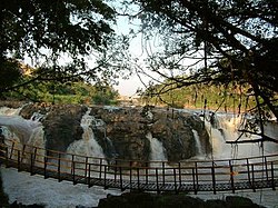
 Dray Sap Falls | |
 | |
| Country | |
| Region | Central Highlands |
| Province | Đắk Nông |
| Capital | Đắk Mâm |
| Area | |
• Total | 315 sq mi (817 km2) |
| Population (2018) | |
• Total | 70,003 |
| Time zone | UTC+7 (Indochina Time) |
Krông Nô is a rural district of Đắk Nông province in the Central Highlands region of Vietnam.
History
[edit]Its name Krông-nô means "the river of the father" in Mnong language.[1] It is named after the largest river flowing through the rural district : Eă Krông-knô (the falls of the father river), Daàk Krông-knô (the stream of the father river). The total basin area of the river is 3,934 km2, with a length of up to 160 km.[2] The reason it is called like that is because from the top of the Cư-yàng-sin Mountain, there are two rivers : Krông-knô (father river) and Krông-ana (mother river). The two then continued to enter another river : Krông-srêpốk (son river).[3]
Geography
[edit]As of 2020 the rural district had a population of 81,821.[4] The district covers an area of 813,49 km².
The district capital lies at Đắk Mâm Township. Besides, it also includes 11 communes : Buôn Choáh, Đắk Đrô, Đắk Năng, Đắk Sôr, Đức Xuyên, Nam Đà, Nam Xuân, Nâm N'Đir, Nâm Nung, Quảng Phú, Tân Thành.
See also
[edit]References
[edit]- ^ Meaning of places in the Central Highlands (vi)
- ^ Quyết-định số 1989/QĐ-TTg của Thủ-tướng Chính-phủ về việc ban-hành Danh-mục lưu-vực sông liên-tỉnh (PDF)
- ^ Quyết-định số 2138/QĐ-TTg của Thủ-tướng Chính-phủ về việc phê-duyệt Quy-hoạch tổng-hợp lưu-vực sông Srêpốk thời-kỳ 2021-2030, tầm nhìn đến năm 2050 (PDF)
- ^ Overview of natural, socio-economic and administrative conditions of Krongkno rural district (vi)
External links
[edit]- Nguyễn-văn-Huy, Ứng phó với những biến động tiêu cực của sông Krông Nô trong mùa lũ (Respond to negative fluctuations of the Krong-kno in the flood season), Daklak Weekly News, October 13, 2012.
12°19′59″N 107°49′59″E / 12.333°N 107.833°E


