Khlong Sam Wa district
Khlong Sam Wa
คลองสามวา | |
|---|---|
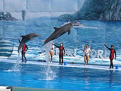
 Dolphin show at Safari World | |
 Khet location in Bangkok | |
| Coordinates: 13°51′35″N 100°42′15″E / 13.85972°N 100.70417°E | |
| Country | Thailand |
| Province | Bangkok |
| Seat | Bang Chan |
| Khwaeng | 5 |
| Khet established | 21 November 1997 |
| Area | |
• Total | 110.686 km2 (42.736 sq mi) |
| Population (2022) | |
• Total | 209,120[1] |
| • Density | 1,889.31/km2 (4,893.3/sq mi) |
| Time zone | UTC+7 (ICT) |
| Postal code | 10510 |
| Geocode | 1046 |
Khlong Sam Wa (Thai: คลองสามวา, pronounced [kʰlɔ̄ːŋ sǎːm wāː]) is one of the 50 districts (khet) of Bangkok, Thailand. It is bounded by other districts (from north clockwise): Lam Luk Ka district of Pathum Thani province, Nong Chok, Min Buri, Khan Na Yao, Bang Khen, and Sai Mai of Bangkok. As of 2022, it had the highest population of all districts in Bangkok.
History
[edit]Khlong Sam Wa was established as a district on 21 November 1997 by splitting from Min Buri. Khlong Sam Wa was the name of an amphoe (district) in Min Buri and hence the name is used as the district name. In 1947 when the area was still rural, the farming community of Bang Chan was chosen as a centre for Thai studies.[2]
Its name "Khlong Sam Wa" literally translates as a khlong (canal) with a width of three wa (5.943 m).[3]
Administration
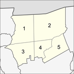
[edit]The district is divided into five sub-districts (khwaeng).
| No. | Name | Thai | Area (km2) |
Map |
|---|---|---|---|---|
1. |
Sam Wa Tawan Tok | สามวาตะวันตก | 24.249 |

|
2. |
Sam Wa Tawan Ok | สามวาตะวันออก | 40.574
| |
3. |
Bang Chan | บางชัน | 18.644
| |
4. |
Sai Kong Din | ทรายกองดิน | 11.396
| |
5. |
Sai Kong Din Tai | ทรายกองดินใต้ | 15.823
| |
| Total | 110.686
| |||
District council
[edit]The district council for Khlong Sam Wa has seven members, who each serve four-year terms. Elections were last held on 30 April 2006. The Thai Rak Thai Party won seven seats.
Places
[edit]Kip Mu
[edit]Kip Mu (กีบหมู, "pig's hoof") is a neighbourhood in Bang Chan sub-district that is widely known as "labour market", owing it is a gathering place for day labours. Every morning, from about 5.00 a.m. until no later than 9.00 a.m., there are employers and contractors drive pickup trucks to hire workmen here. Which are available in a variety of options according to individual aptitudes, such as carpenter, painter, plumber, welder, plasterer or unskilled labour. They would stand in line with thousands of people almost 1 km (0.6 mi) long on both sides of the road to be chosen.[4]
References
[edit]- ^ "Population and House Report for Year 2022 (see page 2 for data of this district)". Department of Provincial Administration, Ministry of Internal Affairs. Retrieved 2023-04-01. (Search page)
- ^ Sharp, Lauriston; Hanks, Lucien M. (Winter 1983). Brian L. Foster. (ed.). "Bang Chan: Social History of a Rural Community in Thailand". Ethnohistory. 30 (1). Duke University Press: 35–36. doi:10.2307/481501. JSTOR 481501. S2CID 165570294.
- ^ Chulasai, Bundit; Chotpanit, Ratchada (2021-05-30). "เขตหนองจอก ลาดกระบัง และคลองสามวา" [Districts of Nong Chok Lat Krabang and Khlong Sam Wa]. Matichon (in Thai). Retrieved 2022-02-16.
- ^ "ชะตากรรมที่สิ้นหวังของ 'แรงงานก่อสร้างตลาดกีบหมู'" [The hopeless fate of 'labours at Kip Mu market']. The MOMENTUM (in Thai). 2021-01-21. Retrieved 2021-09-06.
External links
[edit]

