Khlong Maha Nak subdistrict
Khlong Maha Nak
คลองมหานาค | |
|---|---|
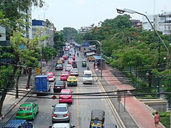
 Krung Kasem Road in the area of Bobae Market and parallel to the Khlong Phadung Krung Kasem | |
 Location in Pom Prap Sattru Phai District | |
| Country | Thailand |
| Province | Bangkok |
| Khet | Pom Prap Sattru Phai |
| Area | |
• Total | 0.448 km2 (0.173 sq mi) |
| Population (2019) | |
• Total | 9,128 |
| Time zone | UTC+7 (ICT) |
| Postal code | 10100 |
| TIS 1099 | 100803 |
Khlong Maha Nak (Thai: คลองมหานาค, pronounced [kʰlɔ̄ːŋ mā.hǎː nâːk]) is one of five khwaengs (subdistricts) of Pom Prap Sattru Phai District, Bangkok.
Naming
[edit]It is named after the Khlong Maha Nak canal that flows through and bisects the area.[2]
Geography
[edit]Roads neighboring this subdistrict include (from the north clockwise): Lan Luang, Worachak, Bamrung Mueang, Krung Kasem.[3]
Khlong Maha Nak, Khlong Phadung Krung Kasem, and Khlong Saen Saep are main watercourses. The Khlong Phadung Krung Kasem canal serves as the boundary between Si Yaek Maha Nak Subdistrict, Dusit District, and Rong Mueang Subdistrict, Pathum Wan District.[2]
Population
[edit]Total population of 9,482 people (4,473 men, and 5,009 women) most of the people are Muslims live in Masjid Maha Nak's neighbourhood by the Khlong Maha Nak. [4]
Places
[edit]- Hua Chiew Hospital
- Thonburi Bamrungmuang Hospital
- Masjid Maha Nak
- Bobae Market
- Bobae Tower
- Prince Palace Hotel
- Ministry of Social Development and Human Security
- Wat Sitaram
- Varadis Palace[2]
References
[edit]- ^ Administrative Strategy Division, Strategy and Evaluation Department, Bangkok Metropolitan Administration (2021). สถิติกรุงเทพมหานครประจำปี 2563 [Bangkok Statistics 2020] (PDF) (in Thai). Retrieved 27 November 2021.
{{cite web}}: CS1 maint: multiple names: authors list (link) - ^ a b c "แขวงคลองมหานาค เขตป้อมปราบศัตรูพ่าย" [Khlong Maha Nak Subdistrict, Pom Prap Sattru Phai District]. Google Maps (in Thai).
- ^ "ข้อมูลแขวงคลองมหานาค เขตป้อมปราบศัตรูพ่าย กรุงเทพมหานคร" [Information of Khlong Maha Nak Subdistrict, Pom Prap Sattru Phai District, Bangkok]. ThaiTambon (in Thai).
- ^ "ข้อมูลทั่วไปของเขต" [General information of the district]. Bangkok (in Thai).
