Kaunas County
Appearance
(Redirected from Kauno Apskritis)
You can help expand this article with text translated from the corresponding article in Lithuanian. (January 2011) Click [show] for important translation instructions.
|
Kaunas County
Kauno apskritis | |
|---|---|
 Kaunas, largest city in county | |
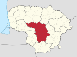
 Location of Kaunas County | |
| Country | |
| Administrative centre | Kaunas |
| Municipalities | |
| Area | |
• Total | 8,086 km2 (3,122 sq mi) |
| (12.4% of the area of Lithuania) | |
| Population (2022) | |
• Total | 623,262[1] |
| • Rank | 2nd of 10 (20.4% of the population of Lithuania) |
| GDP | |
| • Total | €13.7 billion (2022) |
| • Per capita | €23,900 (2022) |
| Time zone | UTC+2 (EET) |
| • Summer (DST) | UTC+3 (EEST) |
| ISO 3166 code | LT-KU |
| HDI (2021) | 0.882[3] very high · 2nd |
 | |
Kaunas County (Lithuanian: Kauno apskritis) is one of ten counties of Lithuania. It is in the centre of the country, and its capital is Kaunas. On 1 July 2010, the county administration was abolished.[4]
Symbols
[edit]The county's coat of arms can be blazoned as follows: Gules, an aurochs head caboshed argent ensigned by a cross Or between his horns enclosed by a bordure purpure charged with ten evenly distributed crosses of Lorraine Or.
The flag's heraldic blazon is identical, since the flag is a banner of the arms.
Municipalities
[edit]The county is subdivided into municipalities:
References
[edit]- ^ "Kauno teritorinė ligonių kasa - Prisirašiusių gyventojų skaičius" (in Lithuanian). Retrieved 9 December 2022.
- ^ "Gross domestic product by region in 2022". osp.stat.gov.lt.
- ^ "Sub-national HDI - Area Database - Global Data Lab". hdi.globaldatalab.org. Retrieved 2018-09-13.
- ^ "Dėl apskričių viršininkų administracijų likvidavimo". Seimas of the Republic of Lithuania. Retrieved 21 August 2011.
External links
[edit]- Social and demographic characteristics of Kaunas County Archived 2011-10-07 at the Wayback Machine
- Economy of Kaunas County Archived 2011-10-07 at the Wayback Machine
- Environment of Kaunas County Archived 2011-10-07 at the Wayback Machine
54°53′50″N 23°53′33″E / 54.89722°N 23.89250°E


