
File:Vancouver Skytrain Current Map.PNG
No higher resolution available.
Vancouver_Skytrain_Current_Map.PNG (782 × 444 pixels, file size: 22 KB, MIME type: image/png)
| This is a file from the Wikimedia Commons. Information from its description page there is shown below. Commons is a freely licensed media file repository. You can help. |
Summary
English:
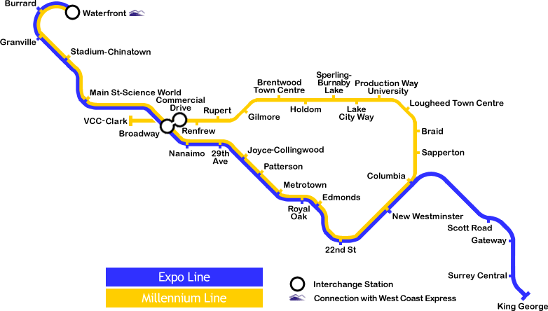
- Description: Current map of the Vancouver Skytrain system
- Author: Yllianos
- Date: unknown ("Made this image a few days ago" [before the November 12, 2005])
- Source: English Wikipedia
- License: This image is copyrighted. The copyright holder allows anyone to use it for any purpose.
Deutsch:
- Beschreibung: Aktuelle Karte des Vancouver Skytrain-Systems
- Autor: Yllianos
- Datum: unbekannt ("Made this image a few days ago", „Habe ich wenige Tage vorher gemacht“ [vor dem 12. November 2005])
- Quelle: Englische Wikipedia
- Lizenz: This image is copyrighted. The copyright holder allows anyone to use it for any purpose. (Dieses Bild ist per Copyright geschützt. Der Autor bzw. Copyright-Inhaber erlaubt die Verwendung für jeden Zweck)
History (from de.wikipedia)
   *  (del) (cur) 17:52, 12 January 2006 . . Yllianos (Talk) . . 782x444 (24484 bytes) (Made this image a few days ago. Yeah, free to use anywhere.)
   * (del) (rev) 18:50, 11 January 2006 . . Yllianos (Talk) . . 782x444 (24500 bytes) (Made this image a few days ago. Yeah, free to use anywhere.)
   * (del) (rev) 18:49, 11 January 2006 . . Yllianos (Talk) . . 782x444 (24500 bytes) (Made this image a few days ago. Yeah, free to use anywhere.)
   * (del) (rev) 18:45, 11 January 2006 . . Yllianos (Talk) . . 782x444 (24235 bytes) (Made this image a few days ago. Yeah, free to use anywhere.)
   * (del) (rev) 18:37, 11 January 2006 . . Yllianos (Talk) . . 782x444 (24186 bytes) (Made this image a few days ago. Yeah, free to use anywhere.)
   * (del) (rev) 04:45, 12 November 2005 . . Yllianos (Talk) . . 782x444 (23975 bytes) (Made this image a few days ago. Yeah, free to use anywhere.)
Licensing

|
The copyright holder of this work allows anyone to use it for any purpose including unrestricted redistribution, commercial use, and modification.
Usage notes:
|

|
This transport map image could be re-created using vector graphics as an SVG file. This has several advantages; see Commons:Media for cleanup for more information. If an SVG form of this image is available, please upload it and afterwards replace this template with
{{vector version available|new image name}}.
It is recommended to name the SVG file “Vancouver Skytrain Current Map.svg”—then the template Vector version available (or Vva) does not need the new image name parameter. |
File history
Click on a date/time to view the file as it appeared at that time.
| Date/Time | Thumbnail | Dimensions | User | Comment | |
|---|---|---|---|---|---|
| current | 20:41, 19 October 2006 | | 782 × 444 (22 KB) | Conscious | newest version from en: |
| 16:53, 2 February 2006 |  | 782 × 444 (22 KB) | Jcornelius | ||
| 16:41, 2 February 2006 |  | 782 × 444 (22 KB) | Jcornelius | {{English}} * Description: Current map of the Vancouver Skytrain system * Author: Yllianos * Date: unknown (''"Made this image a few days ago"'' [before the November 12, 2005]) * Source: [http://wiki.riteme.site/wiki/Image:SkyTrainCu |
File usage
No pages on the English Wikipedia use this file (pages on other projects are not listed).
Global file usage
The following other wikis use this file:
- Usage on pt.wikivoyage.org