Jump to content

File:London 1300 Historical Atlas William R Shepherd (died 1934).PNG

Page contents not supported in other languages.
This is a file from the Wikimedia Commons
From Wikipedia, the free encyclopedia

London_1300_Historical_Atlas_William_R_Shepherd_(died_1934).PNG (700 × 536 pixels, file size: 644 KB, MIME type: image/png)

This file has been superseded by Plan of London in 1300.jpg. It is recommended to use the other file. Please note that deleting superseded images requires consent.
new file
File:Map of London, 1300.svg is a vector version of this file. It should be used in place of this PNG file when not inferior.

File:London 1300 Historical Atlas William R Shepherd (died 1934).PNG → File:Map of London, 1300.svg

For more information, see Help:SVG.

In other languages
Alemannisch  Bahasa Indonesia  Bahasa Melayu  British English  català  čeština  dansk  Deutsch  eesti  English  español  Esperanto  euskara  français  Frysk  galego  hrvatski  Ido  italiano  lietuvių  magyar  Nederlands  norsk bokmål  norsk nynorsk  occitan  Plattdüütsch  polski  português  português do Brasil  română  Scots  sicilianu  slovenčina  slovenščina  suomi  svenska  Tiếng Việt  Türkçe  vèneto  Ελληνικά  беларуская (тарашкевіца)  български  македонски  нохчийн  русский  српски / srpski  татарча/tatarça  українська  ქართული  հայերեն  বাংলা  தமிழ்  മലയാളം  ไทย  한국어  日本語  简体中文  繁體中文  עברית  العربية  فارسی  +/−
New SVG image

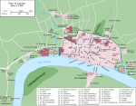
Source: en:Image:London 1300 Historical Atlas William R Shepherd (died 1934).PNG, 03:43, 14 May 2005 . . CalJW (Talk) . . 700x536 (659,361 bytes) (A map of London in 1300 from a historical atlas by William R Shepherd. Apart from religious foundations and two or three other complexes, the city is confined within its walls, which are well inside the present boundary of the City of London. The City)

English: A map of London in 1300 from a historical atlas by William R Shepherd. Apart from religious foundations and two or three other complexes, the city is confined within its walls, which are well inside the present boundary of the City of London. The City is flanked to the east and west by the royal fortress of the Tower of London and the royal palace of Bridewell. The route from the city to the royal centre of Westminster is not yet fully built up. There is a settlement at Southwark, but it is very small.


Public domain

This work is in the public domain in its country of origin and other countries and areas where the copyright term is the author's life plus 70 years or fewer.


You must also include a United States public domain tag to indicate why this work is in the public domain in the United States.
This file has been identified as being free of known restrictions under copyright law, including all related and neighboring rights.

Captions

Add a one-line explanation of what this file represents

Items portrayed in this file

depicts

image/png

File history

Click on a date/time to view the file as it appeared at that time.

Date/TimeThumbnailDimensionsUserComment
current18:20, 20 May 2006Thumbnail for version as of 18:20, 20 May 2006700 × 536 (644 KB)SiebrandHigher resolution from source
07:59, 25 October 2005Thumbnail for version as of 07:59, 25 October 2005299 × 229 (134 KB)JaT~commonswikiMap of London 1300

The following page uses this file:

Global file usage

The following other wikis use this file:

Metadata