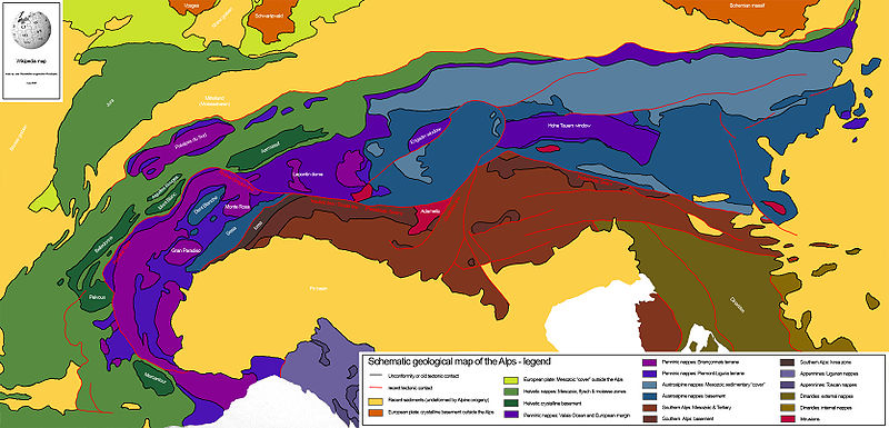
File:Alps geology map en.jpg
Appearance

Size of this preview: 800 × 385 pixels. Other resolutions: 320 × 154 pixels | 640 × 308 pixels | 1,024 × 493 pixels | 1,280 × 616 pixels | 3,338 × 1,607 pixels.
Original file (3,338 × 1,607 pixels, file size: 1.86 MB, MIME type: image/jpeg)
File history
Click on a date/time to view the file as it appeared at that time.
| Date/Time | Thumbnail | Dimensions | User | Comment | |
|---|---|---|---|---|---|
| current | 21:24, 14 July 2008 |  | 3,338 × 1,607 (1.86 MB) | Ori~ | source: http://wiki.riteme.site/wiki/Image:Alps_geology_map_en.jpg == Summary == Drew this map myself. en:User:Woodwalker 14:53, 2 June 2006 (UTC) == Licensing == {{PD-self}} |
File usage
The following 26 pages use this file:
- Aarmassif
- Adriatic plate
- Austroalpine nappes
- Briançonnais zone
- Bündner schist
- Dent Blanche nappe
- Engadin window
- Engadine Line
- Geology of the Alps
- Giudicarie Line
- Greywacke zone
- Helvetic (geology)
- Hohe Tauern window
- Ivrea zone
- Lepontin dome
- Molasse basin
- Penninic
- Penninic thrustfront
- Periadriatic Seam
- Piemont-Liguria Ocean
- Rhône-Simplon line
- Sesia zone
- Southern Alps (Europe)
- Valais Ocean
- Wetterstein Formation
- Template:Geology of the Alps
Global file usage
The following other wikis use this file:
- Usage on eu.wikipedia.org
- Usage on fr.wikipedia.org
- Usage on sl.wikipedia.org
