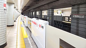
Honjo-azumabashi Station
Appearance
(Redirected from Honjo-Azumabashi Station)
A19 Honjo-azumabashi Station 本所吾妻橋駅 | |||||||||||
|---|---|---|---|---|---|---|---|---|---|---|---|
 Platform level of Honjo-azumabashi Station | |||||||||||
| General information | |||||||||||
| Location | 3 Azumabashi, Sumida City, Tokyo Japan | ||||||||||
| Operated by | |||||||||||
| Line(s) | A Asakusa Line | ||||||||||
| Platforms | 2 side platforms | ||||||||||
| Tracks | 2 | ||||||||||
| Construction | |||||||||||
| Structure type | Underground | ||||||||||
| Other information | |||||||||||
| Station code | A-19 | ||||||||||
| History | |||||||||||
| Opened | 4 December 1960 | ||||||||||
| Services | |||||||||||
| |||||||||||
| |||||||||||
Honjo-azumabashi Station (本所吾妻橋駅, Honjo-azumabashi-eki) is a subway station on the Toei Asakusa Line, operated by the Toei. It is located in Sumida, Tokyo, Japan. Its number is A-19.[1]
Station layout
[edit]Honjo-azumabashi Station has two side platforms serving two tracks.[1]
Platforms
[edit]| 1 | A Asakusa Line | for Nihombashi, Sengakuji, and Nishi-magome KK Keikyū Main Line for Shinagawa, Haneda Airport (International Terminal and Domestic Terminal), and Misakiguchi |
| 2 | A Asakusa Line | for Oshiage KS Keisei Main Line for Keisei Funabashi, Keisei Narita, and Narita Airport (Terminal 2·3 and Terminal 1) KS Narita Sky Access Line for Narita Airport HS Hokusō Line for Imba Nihon-idai SR Shibayama Railway Line for Shibayama-Chiyoda |
History
[edit]Honjo-azumabashi Station opened on December 4, 1960, as a station on Toei Line 1. In 1978, the line was given its present name.
Surrounding area
[edit]The station serves the Azumabashi bridge neighborhood. Nearby are the local police station, the Sumida Ward office (city hall), and the headquarters of Asahi Breweries.
References
[edit]- ^ a b "Honjo-azumabashi". Toei Transportation. Retrieved January 15, 2024.
Wikimedia Commons has media related to Honjo-azumabashi Station.
35°42′30.96″N 139°48′16.75″E / 35.7086000°N 139.8046528°E


