Arkansas Highway 340
| Lancashire Boulevard[1] | ||||
 | ||||
| Route information | ||||
| Maintained by AHTD | ||||
| Length | 9.21 mi[3] (14.82 km) | |||
| Existed | August 25, 1965[2]–present | |||
| Major junctions | ||||
| West end | ||||
| East end | ||||
| Location | ||||
| Country | United States | |||
| State | Arkansas | |||
| Counties | Benton | |||
| Highway system | ||||
| ||||
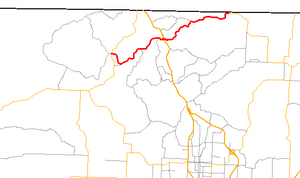
Highway 340 (AR 340, Ark. 340, Hwy. 340, also Lancashire Boulevard)[1] is an east–west state highway in Benton County, Arkansas. The route of 9.21 miles (14.82 km) runs entirely across Bella Vista, from Arkansas Highway 279 in the west to Arkansas Highway 94 in the east.[4]
Route description
[edit]
The highway begins in west Bella Vista at Forest Hills Boulevard near the Northwest Arkansas Community College Bella Vista campus. AR 340 winds past numerous retirement communities and a few lakes on its way through the village. Approximately halfway along its length, AR 340 intersects US Route 71, which is a four-lane expressway. The interchange with US 71 is unusual, with long ramps on the northbound side and cramped southbound ramps. Traffic must exit US 71 and slow immediately to 20 mph (32 km/h) on a 180 degree curve before stopping and gaining access to AR 340.
On the other side of US 71, the highway runs near the Mildred B. Cooper Memorial Chapel, built by local architect E. Fay Jones (in similar style to the Thorncrown Chapel on the National Register of Historic Places). Highway 340 continues to wind northeast past communities and cul-de-sacs before meeting Pickens Rd, which continues briefly before becoming Missouri supplemental route E.[4]
History
[edit]The route was added to the state highway system on August 25, 1965.[2] Described as the road from northeast of Hiwasse to the junction of Highway 94 at the Missouri state line, the routing has changed little since first designation.
Major intersections
[edit]
The entire route is in Bella Vista, Benton County.
| mi[3] | km | Destinations | Notes | ||
|---|---|---|---|---|---|
| 0.00 | 0.00 | Western terminus | |||
| 4.26 | 6.86 | Interchange; US 71 exit 98 | |||
| 9.21 | 14.82 | Eastern terminus | |||
| 1.000 mi = 1.609 km; 1.000 km = 0.621 mi | |||||
See also
[edit]References
[edit]- ^ a b Google Maps (Map). Google. Retrieved May 5, 2009.
- ^ a b "Minutes of the Meeting" (PDF). Arkansas State Highway Commission. August 25, 1965. p. 711. Archived from the original (PDF) on October 1, 2018. Retrieved January 28, 2013.
- ^ a b Planning and Research Division (2010). "Arkansas Road Log Database". Arkansas State Highway and Transportation Department. Archived from the original (Database) on 23 June 2011. Retrieved June 9, 2011.
- ^ a b General Highway Map (PDF) (Map) (Benton County ed.). Arkansas State Highway and Transportation Department. Archived (PDF) from the original on 7 July 2011. Retrieved June 19, 2011.
External links
[edit]![]() Media related to Arkansas Highway 340 at Wikimedia Commons
Media related to Arkansas Highway 340 at Wikimedia Commons

